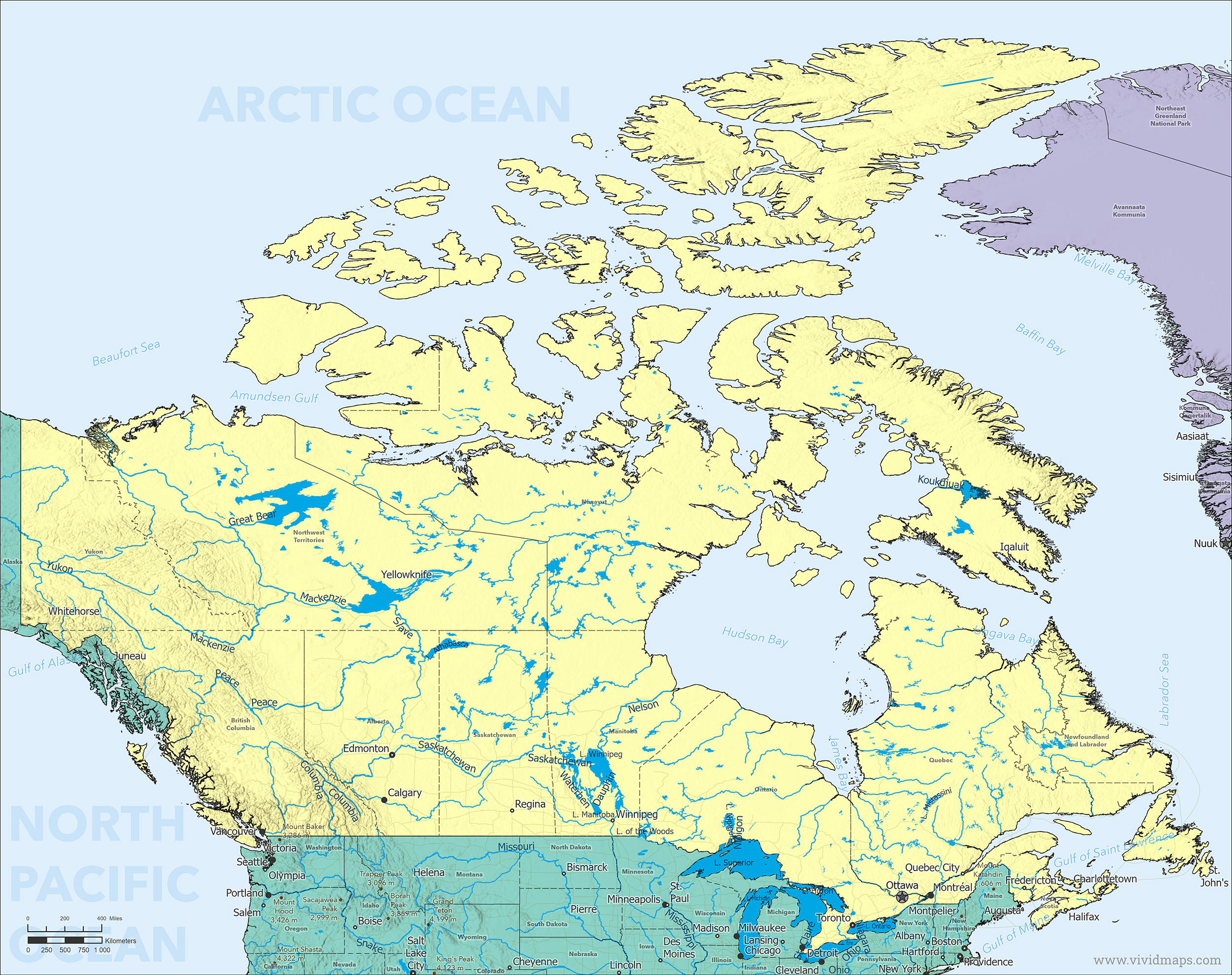
Map of Canada
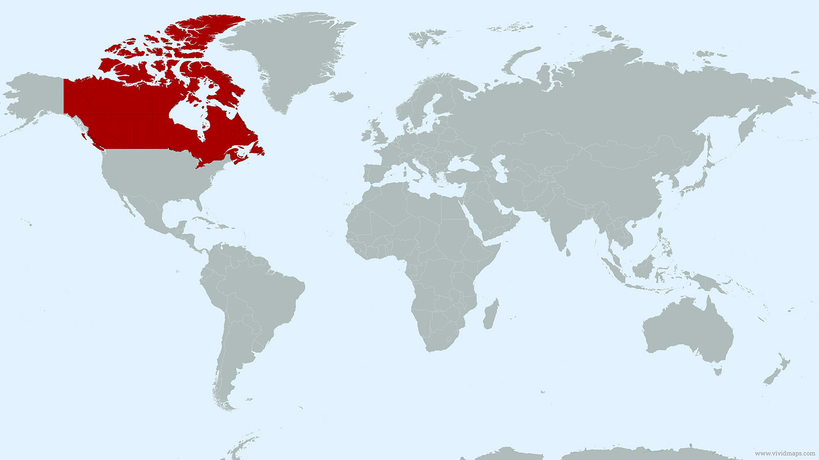
Canada Location Map
Canada Facts
Full Official Name: Canada
Demonym: Canadian
Flag:
Area
Total Area: 9,984,670 km² (3,855,100 mi²)
Land Area: 9,093,507 km² (3,511,023 mi²)
Water Area: 891,163 km² (344,077 mi²)
Highest and Lowest Points
Highest Point: Mount Logan — 5,959 m (19,551 ft)
Lowest Point: Coastline – the country has no naturally occurring points of land below sea level. Lowest inland point – Great Slave Lake (-614 m / -2,014 ft)
Demographics
Population: 40,528,396 (2024 est.)
Population Growth Rate: 1.9% (2024 est.)
Largest City: Toronto — 2,794,356 inhabitants
Ethnic Groups:
Canadian 15.6%, English 14.7%, Scottish 12.1%, French 11.0%, Irish 12.1%, German 8.1%, Chinese 4.7%, Italian 4.3%, First Nations 2.6%, Indian 2.6%, Other 17.2% (2021 est.)
Languages:
English 75.4% (official), French 23.3% (official), Chinese languages 4.2%, Spanish 3.2%, Punjabi 2.6%, Arabic 2.4%, Tagalog 2.3%, Italian 1.5% (2022 est.)
Religions:
Christian 53.3% (Catholic 29.9%, Protestant 18.3%, Orthodox 2.0%, Other Christian 3.1%)
Muslim 4.9%, Hindu 2.3%, Sikh 2.1%, Buddhist 1.0%, Jewish 1.0%, None 34.6% (2021 est.)
Economy
Currency: Canadian Dollar (CAD)
Real GDP (PPP): $2.730 trillion (2025 est.)
GDP per Capita (PPP): $65,707 (2025 est.)
Gini Index: 29.2 (2024 est.)
Human Development Index (HDI): 0.939 (2023)
Exports: $694.5 billion (2023 est.)
Main Export Partners: United States 77%, China 4%, United Kingdom 3%, Japan 2%, Mexico 1.5% (2023)
Imports: $726.7 billion (2023 est.)
Main Import Partners: United States 49%, China 13%, Mexico 6%, Germany 3%, Japan 2% (2023)
Government
Type: Federal parliamentary democracy (constitutional monarchy)
Capital City: Ottawa — population 1,017,449
Other Facts
Time Zones: UTC−3.5 to −8 (standard), UTC−2.5 to −7 (DST)
Country Code: CA
Internet TLD: .ca
Dialing code: +1
Climate Map Canada
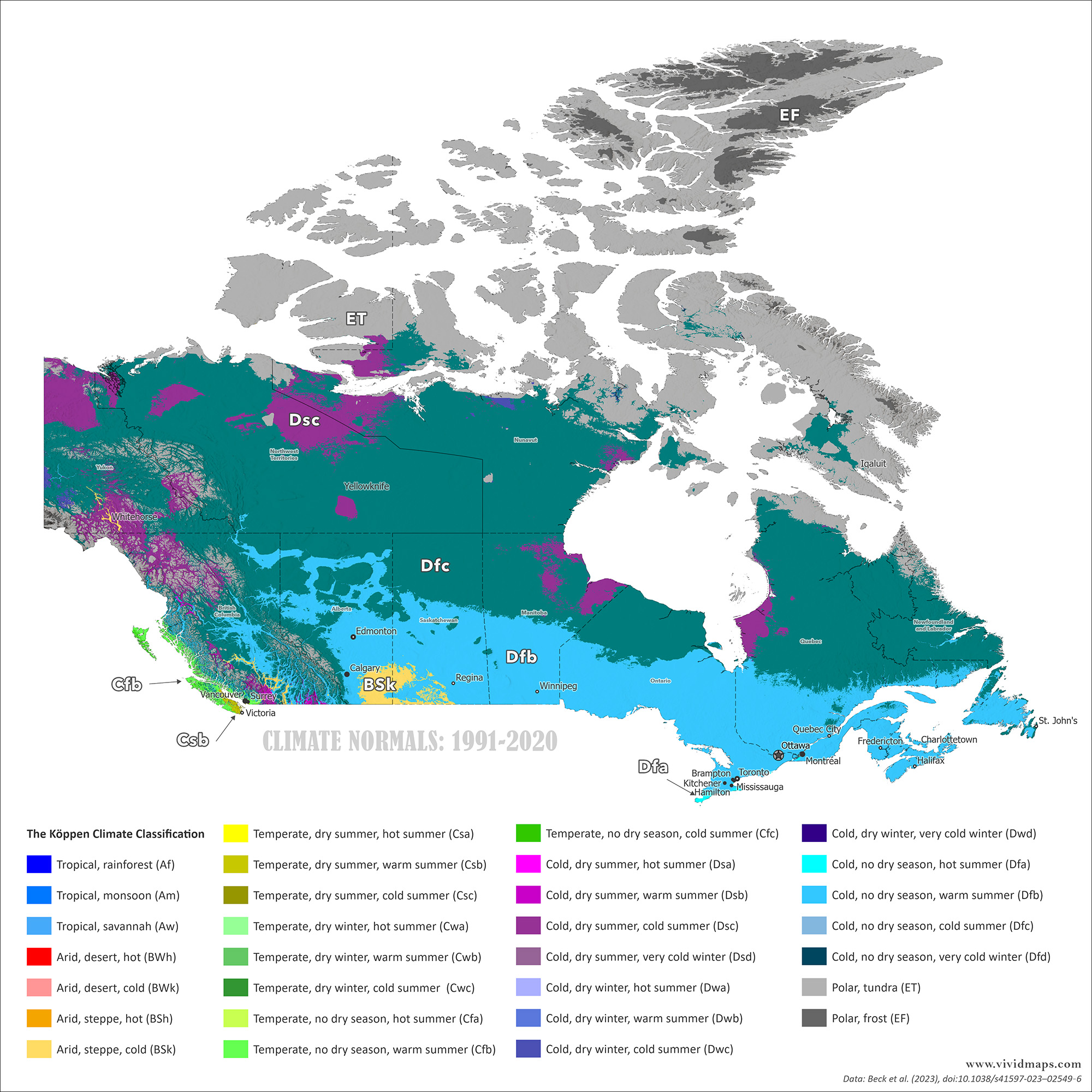
Canada’s climate ranges from temperate along the southern border to subarctic and arctic in the north.
Coastal British Columbia experiences a mild oceanic climate, while the Prairies see cold winters and warm summers. The northern territories are defined by permafrost and polar conditions.
Most Canadians live within 200 km of the U.S. border, where the climate is generally more moderate (How Canada’s climate will change in the future you can find here).
Climate of Major Cities (1991–2020 Normals)
Average Daily Mean Temperature — °C (°F)
| City | Jan | Feb | Mar | Apr | May | Jun | Jul | Aug | Sep | Oct | Nov | Dec | Year | Köppen System |
|---|---|---|---|---|---|---|---|---|---|---|---|---|---|---|
| Toronto | −2.9 (26.8) | −1.8 (28.8) | 2.3 (36.1) | 8.5 (47.3) | 14.7 (58.5) | 19.9 (67.8) | 22.9 (73.2) | 21.8 (71.2) | 17.5 (63.5) | 10.9 (51.6) | 5.0 (41.0) | −0.8 (30.6) | 9.0 (48.2) | Dfa |
| Montréal | −9.7 (14.5) | −7.6 (18.3) | −1.6 (29.1) | 6.4 (43.5) | 13.5 (56.3) | 18.7 (65.7) | 21.6 (70.9) | 20.1 (68.2) | 14.4 (57.9) | 8.1 (46.6) | 1.1 (34.0) | −6.7 (19.9) | 6.0 (42.8) | Dfb |
| Vancouver | 4.4 (39.9) | 5.6 (42.1) | 7.7 (45.9) | 10.1 (50.2) | 13.6 (56.5) | 16.5 (61.7) | 18.5 (65.3) | 18.6 (65.5) | 15.3 (59.5) | 10.8 (51.4) | 6.5 (43.7) | 4.4 (39.9) | 11.0 (51.8) | Cfb |
| Calgary | −7.3 (18.9) | −5.3 (22.5) | −0.3 (31.5) | 6.1 (43.0) | 11.5 (52.7) | 15.4 (59.7) | 17.6 (63.7) | 16.8 (62.2) | 12.1 (53.8) | 6.1 (43.0) | −1.6 (29.1) | −6.1 (21.0) | 6.0 (42.8) | Dfb |
| Edmonton | −10.4 (13.3) | −8.2 (17.2) | −2.5 (27.5) | 5.2 (41.4) | 11.5 (52.7) | 15.6 (60.1) | 17.5 (63.5) | 16.1 (61.0) | 10.6 (51.1) | 4.3 (39.7) | −4.6 (23.7) | −9.7 (14.5) | 5.0 (41.0) | Dfb |
Average Monthly Precipitation — mm
| City | Jan | Feb | Mar | Apr | May | Jun | Jul | Aug | Sep | Oct | Nov | Dec | Year | Köppen System |
|---|---|---|---|---|---|---|---|---|---|---|---|---|---|---|
| Toronto | 61 | 54 | 61 | 68 | 74 | 72 | 64 | 79 | 83 | 73 | 79 | 66 | 814 | Dfa |
| Montréal | 73 | 58 | 64 | 77 | 83 | 92 | 93 | 94 | 90 | 86 | 90 | 84 | 984 | Dfb |
| Vancouver | 150 | 106 | 113 | 88 | 65 | 53 | 35 | 36 | 49 | 106 | 188 | 168 | 1,157 | Cfb |
| Calgary | 13 | 11 | 17 | 25 | 54 | 83 | 67 | 52 | 41 | 22 | 19 | 15 | 419 | Dfb |
| Edmonton | 20 | 15 | 20 | 26 | 55 | 83 | 90 | 73 | 49 | 33 | 26 | 22 | 512 | Dfb |
Water Bodies
Major lakes (by area): Huron (Great Lakes areas shown as Canadian waters) – 35,972 sq km (13,888 sq mi); Great Bear Lake – 31,328 sq km (12,096 sq mi); Superior* – 28,754 sq km (11,100 sq mi); Great Slave Lake – 28,568 sq km (11,030 sq mi); Lake Winnipeg – 24,387 sq km (9,416 sq mi); Erie – 12,776 sq km (4,932 sq mi); Ontario* – 9,790 sq km (3,780 sq mi); Lake Athabasca – 7,935 sq km (3,063 sq mi); Reindeer Lake – 6,650 sq km (2,568 sq mi); Nettilling Lake – 5,542 sq km (2,139 sq mi)
Major rivers (by length): Mackenzie – 4,241 km (2,635 mi); Yukon river source (shared with the US) – 3,185 km (1,979 mi); Saint Lawrence river mouth (shared with US) – 3,058 km (1,900 mi); Nelson – 2,570 km (1,597 mi); Columbia river source (shared with the US) – 1,953 km (1,214 mi); Churchill – 1,600 km (994 mi); Fraser – 1,368 km (850 mi); Ottawa – 1,271 km (790 mi); Athabasca – 1,231 km (765 mi); North Saskatchewan – 1,220 km (758 mi); Liard – 1,115 km (693 mi)
Read More About Canada
- Official Government of Canada Website
- Canada on the CIA World Factbook
- Canada on Wikipedia
- Canada on Britannica
- Canada on National Geographic Kids
See other country maps here.