Map of the United States
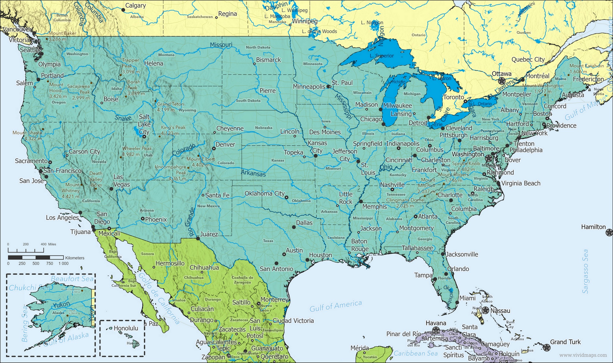
United States Location Map

United States Facts
Full Official Name: United States of America
Demonym: American
Flag:
Area
- Total Area: 9,833,517 km² (3,796,742 mi²)
- Land Area: 9,147,593 km² (3,531,844 mi²)
- Water Area: 685,924 km² (264,918 mi²)
Highest and Lowest Points
Highest Point: Denali (formerly Mount McKinley) — 6,190.5 m. (20,310 ft.)
Lowest Point: Badwater Basin — −86 m (−282 ft)
Demographics
- Population: 341,963,408 (2024 est.)
- Population Growth Rate: 0.67% (2024 est.)
- Largest City: New York City — 8,804,190 inhabitants
Ethnic Groups:
White 61.6%, Black or African American 12.4%, Asian 6%, Indigenous and Alaska Native 1.1%, Native Hawaiian and Other Pacific Islander 0.2%, Other 8.4%, Two or more races 10.2% (2020 est.)
Languages:
English only 78.2%, Spanish 13.4%, Chinese 1.1%, Other 7.3% (2017 est.)
Religions:
Protestant 33%, Roman Catholic 22%, Jewish 2%, Other Christian 11%, Mormonism 1%, Muslim 0.9%, Jehovah’s Witness 0.8%, Buddhist 0.7%, Hindu 0.7%, Other 1.8%, Unaffiliated 22.8%, Don’t know/refused 0.6% (220 est.)
Economy
- Currency: U.S. Dollar (USD)
- Real GDP (PPP): $24.662 trillion (2023 est.)
- GDP per Capita (PPP): $73,600 (2023 est.)
- Gini Index: 41.5 (2023 est.)
- Human Development Index (HDI): 0.921 (2023)
- Exports: $3.052 trillion (2023 est.)
- Main Export Partners: Canada 16%, Mexico 15%, China 8%, Japan 4%, UK 4% (2022)
- Imports: $3.832 trillion (2023 est.)
- Main Import Partners: China 18%, Canada 14%, Mexico 14%, Germany 5%, Japan 4% (2022)
Government
- Type: Constitutional federal republic
- Capital City: Washington, D.C. — population 689,545
Other Facts
- Time Zones: UTC−4 to −12, +10, +11; UTC−4 to −10 (DST)
- Country Code: US
- Internet TLD: .us
- Dialing code: +1
Climate Map of the United States
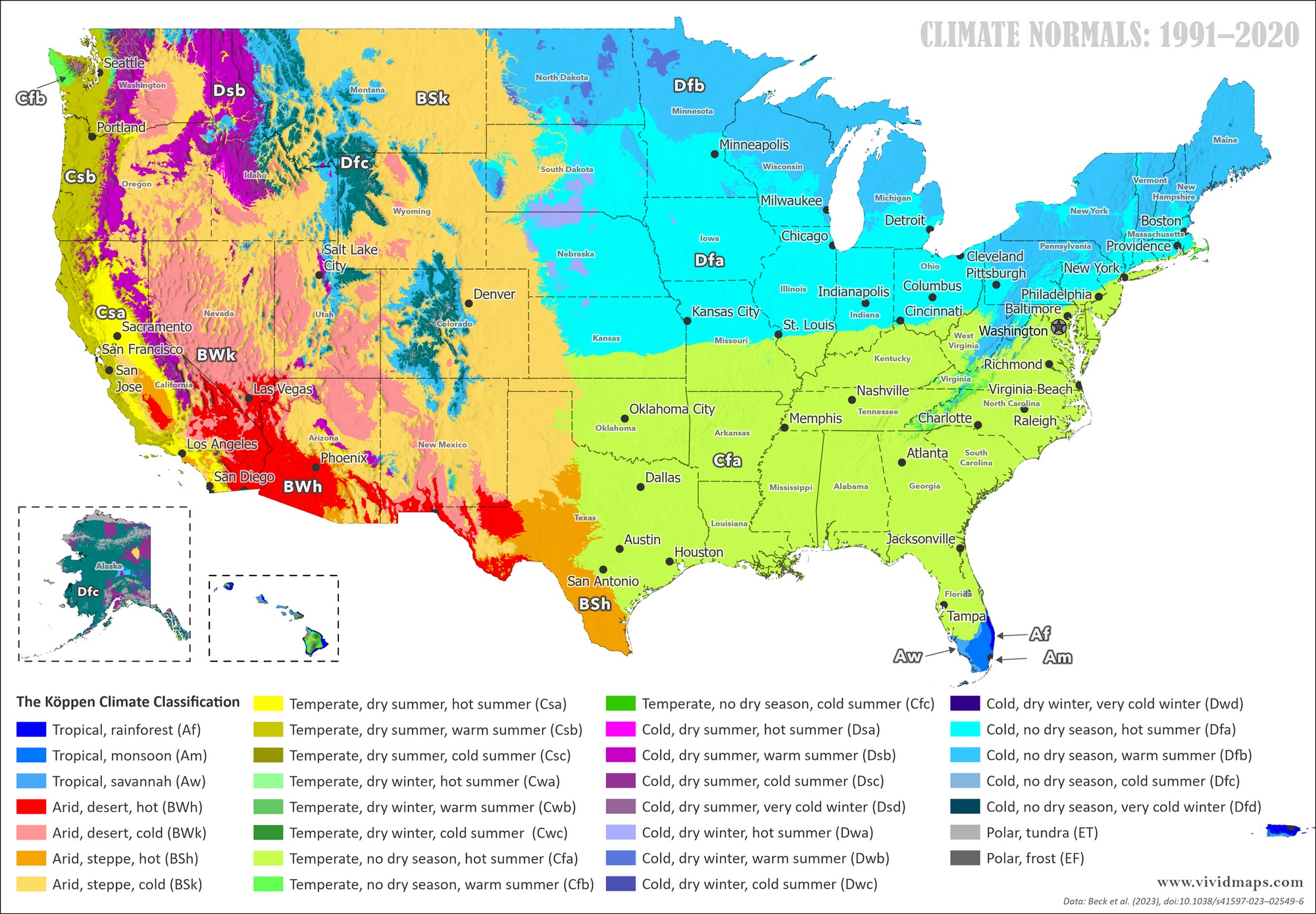
The climate of the United States varies widely — mostly temperate, but tropical in Hawaii and Florida, arctic in Alaska, semiarid in the Great Plains west of the Mississippi River, and arid in the Great Basin and Southwest.
Low winter temperatures in the northwest are sometimes moderated by warm chinook winds from the Rocky Mountains.
Climate of Major Cities (1991–2020 Normals)
Average Daily Mean Temperature — °C (°F)
| City | Jan | Feb | Mar | Apr | May | Jun | Jul | Aug | Sep | Oct | Nov | Dec | Year | Köppen System |
|---|---|---|---|---|---|---|---|---|---|---|---|---|---|---|
| Washington, D.C. | 3.3 (37.9) | 4.9 (40.8) | 9.5 (49.1) | 14.8 (58.6) | 19.8 (67.6) | 24.9 (76.8) | 27.8 (82.0) | 26.8 (80.2) | 22.9 (73.2) | 16.4 (61.5) | 10.5 (50.9) | 5.1 (41.2) | 15.5 (59.9) | Cfa |
| New York City | 1.0 (33.8) | 2.2 (36.0) | 6.0 (42.8) | 11.5 (52.7) | 17.2 (63.0) | 22.5 (72.5) | 25.3 (77.5) | 24.5 (76.1) | 20.4 (68.7) | 14.2 (57.6) | 8.5 (47.3) | 3.5 (38.3) | 13.3 (55.9) | Cfa |
| Chicago | −3.7 (25.3) | −1.3 (29.7) | 4.6 (40.3) | 11.1 (52.0) | 17.0 (62.6) | 22.4 (72.3) | 24.9 (76.8) | 23.9 (75.0) | 19.3 (66.7) | 12.4 (54.3) | 5.0 (41.0) | −1.8 (28.8) | 11.1 (52.0) | Dfa |
| Houston | 12.0 (53.6) | 13.8 (56.8) | 17.4 (63.3) | 21.6 (70.9) | 25.4 (77.7) | 28.2 (82.8) | 29.4 (84.9) | 29.4 (84.9) | 27.5 (81.5) | 22.6 (72.7) | 17.1 (62.8) | 13.1 (55.6) | 22.3 (72.1) | Cfa |
| Los Angeles | 13.9 (57.0) | 14.7 (58.5) | 15.6 (60.1) | 16.8 (62.2) | 18.5 (65.3) | 20.8 (69.4) | 23.3 (73.9) | 23.7 (74.7) | 22.7 (72.9) | 20.0 (68.0) | 16.5 (61.7) | 13.9 (57.0) | 18.4 (65.1) | Csa |
Average Monthly Precipitation — mm
| City | Jan | Feb | Mar | Apr | May | Jun | Jul | Aug | Sep | Oct | Nov | Dec | Year | Köppen System |
|---|---|---|---|---|---|---|---|---|---|---|---|---|---|---|
| Washington, D.C. | 79 | 69 | 96 | 82 | 97 | 89 | 97 | 84 | 93 | 85 | 86 | 83 | 1,040 | Cfa |
| New York City | 85 | 77 | 99 | 101 | 99 | 97 | 117 | 109 | 96 | 95 | 94 | 89 | 1,158 | Cfa |
| Chicago | 43 | 49 | 66 | 94 | 97 | 97 | 97 | 100 | 89 | 75 | 73 | 58 | 938 | Dfa |
| Houston | 101 | 83 | 94 | 93 | 137 | 168 | 97 | 146 | 132 | 126 | 105 | 112 | 1,394 | Cfa |
| Los Angeles | 79 | 76 | 60 | 25 | 7 | 2 | 0 | 1 | 3 | 10 | 30 | 53 | 346 | Csa |
Water Bodies
Major lakes (by area: Michigan (Great Lakes area shown as US waters) – 57,750 sq km (22,297 sq mi); Superior – 53,348 sq km (20,598 sq mi); Huron – 23,597 sq km (9,111 sq mi); Erie – 12,890 sq km (4,977 sq mi); Ontario – 9,220 sq km (3,560 sq mi); Lake of the Woods – 4,350 sq km (1,680 sq mi); Iliamna – 2,590 sq km (1,000 sq mi); Okeechobee – 1,810 sq km (699 sq mi); Belcharof – 1,190 sq km (459 sq mi); Red – 1,170 sq km (452 sq mi); Saint Clair – 1,113 sq km (430 sq mi); Champlain – 1,100 sq km (425 sq mi); Great Salt – 4,360 sq km (1,683 sq mi); Pontchartrain – 1,620 sq km (625 sq mi); Selawik – 1,400 sq km (540 sq mi); Salton Sea – 950 sq km (367 sq mi)
Major rivers (by length): Missouri – 3,768 km (2,340 mi); Mississippi – 3,544 km (2,202 mi); Yukon river mouth (shared with Canada [s]) – 3,190 km (1,982 mi); Saint Lawrence (shared with Canada) – 3,058 km (1,900 mi); Rio Grande river source (mouth shared with Mexico) – 3,057 km (1,899 mi); Colorado river source (shared with Mexico [m]) – 2,333 km (1,449 mi); Arkansas – 2,348 km (1,459 mi); Columbia river mouth (shared with Canada [s]) – 2,250 km (1,398 mi); Red – 2,188 km (1,360 mi); Ohio – 2,102 km (1,306 mi); Snake – 1,670 km (1,038 mi)
Read More About the United States
- Official United States Website
- United States on the CIA World Factbook
- United States on Wikipedia
- United States on Britannica
- United States on National Geographic Kids
Thinking about getting a printed map of the United States? You can browse a curated selection of high-quality wall maps here. See other country maps here.