New York City Maps: A Visual Journey Through the Big Apple
New York City, a metropolis that captivates the imagination of millions, is a complex blend of cultures, neighborhoods, and experiences. To truly understand this iconic city, sometimes you need to step back and view it from a different perspective. That’s where maps come in handy. They offer unique insights into the city’s geography, culture, and even its residents’ mindsets.
In this growing collection, we’ll explore various maps that shed light on different aspects of New York City. From humorous interpretations to detailed analyses, each map tells a story about the city that never sleeps. Let’s dive in!
Table of Contents
- 1. The New Yorker’s Worldview
- 2. New York City: TheCenter of the World
- 3. Manhattan’s Neighborhood Mosaic
- 4. The Diverse Makeup of New York City’s Demographics
- 5. The Economic Landscape of the Big Apple
- 6. The NYC Subway Map: Design vs. Reality
- 7. Navigating the Urban Jungle: NYC’s Transportation Accessibility
- 8. The Rodent Density Map: NYC’s Underground Residents
- More Maps to Come!
- Explore Further with NYC Maps on Amazon
1. The New Yorker’s Worldview
Ever wondered how New Yorkers see the world? Saul Steinberg’s iconic 1976 New Yorker magazine cover provides a hilarious and thought-provoking answer. This map showcases Manhattan’s skyscrapers dominating the foreground, while the rest of the world fades into obscurity in the distance. It’s a playful jab at the stereotypical New Yorker’s self-centered worldview, but it’s also a testament to the city’s larger-than-life presence in our cultural imagination.

Explore how New Yorkers see the world
2. New York City: TheCenter of the World
Taking the concept of New York’s outsized ego to new heights, this map blows up the Big Apple to nearly the size of the entire continental United States. It’s a visual gag that speaks volumes about the city’s perception of itself and its place in the world during the 1970s. While undoubtedly exaggerated, this map captures the essence of New York’s undeniable global influence and its residents’ pride.

See New York City as the center of the world
3. Manhattan’s Neighborhood Mosaic
Manhattan may seem like a unified entity from afar, but zoom in, and you’ll discover a rich patchwork of neighborhoods, each with its own distinct character. This guide offers an in-depth look at the diverse communities that make up New York City’s most famous borough. From the artistic enclaves of Greenwich Village to the towering skyscrapers of Midtown, explore the unique flavors that make Manhattan a world unto itself.

Discover Manhattan’s neighborhoods
4. The Diverse Makeup of New York City’s Demographics
New York City’s reputation as a melting pot comes to life in this race and ethnicity map. The city’s diversity is on full display, with non-Hispanic whites making up about 33% of the population, followed by Hispanic individuals at 29%, and African Americans at 24%. This visual representation offers insights into the city’s multicultural makeup and the geographic distribution of different communities across the five boroughs.

Explore New York City’s demographic landscape
5. The Economic Landscape of the Big Apple
New York City’s economy is as diverse and complex as its population. This series of maps peels back the layers of the city’s economic ecosystem, revealing neighborhood-level indicators, mobility patterns, and opportunity insights. From the financial powerhouses of Wall Street to the small businesses that form the backbone of local communities, these maps offer a comprehensive look at the economic forces shaping the city.

Delve into New York’s economic geography
6. The NYC Subway Map: Design vs. Reality
The iconic New York City subway map is a masterpiece of design, but how accurately does it represent the city’s geography? This fascinating comparison reveals the differences between the subway map and real geographic distances. Discover how the map’s designers balanced functionality with necessary spatial distortions, creating a tool that helps millions navigate the city daily while sacrificing some geographic accuracy.
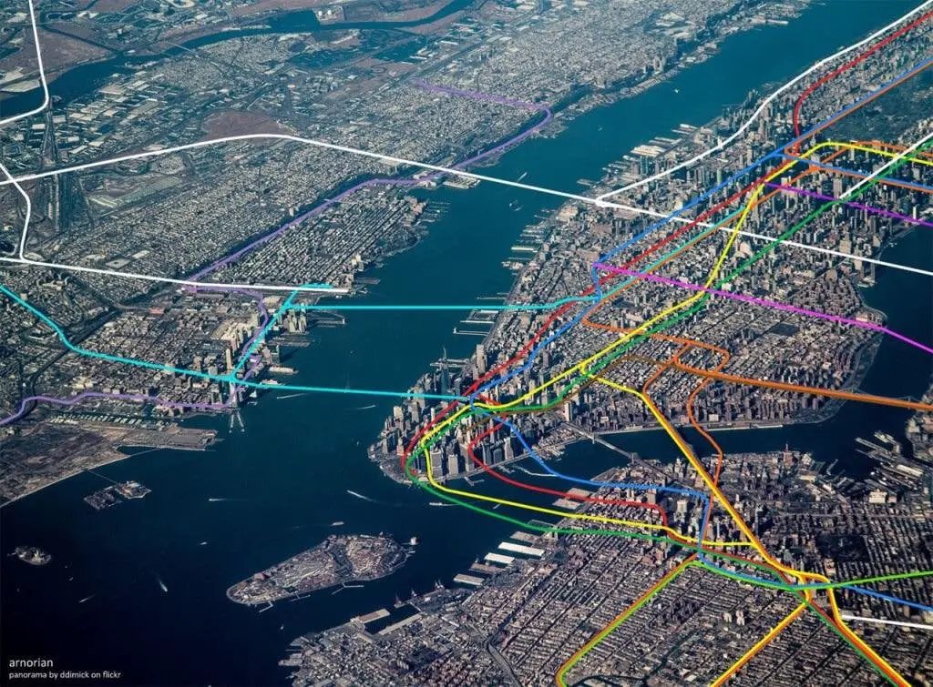
Compare the NYC subway map to reality
Getting around New York City can be an adventure in itself. This comprehensive look at the city’s transportation system explores how different modes of transit affect accessibility across various neighborhoods. From subway-only commutes to the impact of bus routes, these interactive maps and borough-specific data offer valuable insights into the daily journey of New Yorkers as they traverse their urban landscape.

Uncover NYC’s transportation accessibility
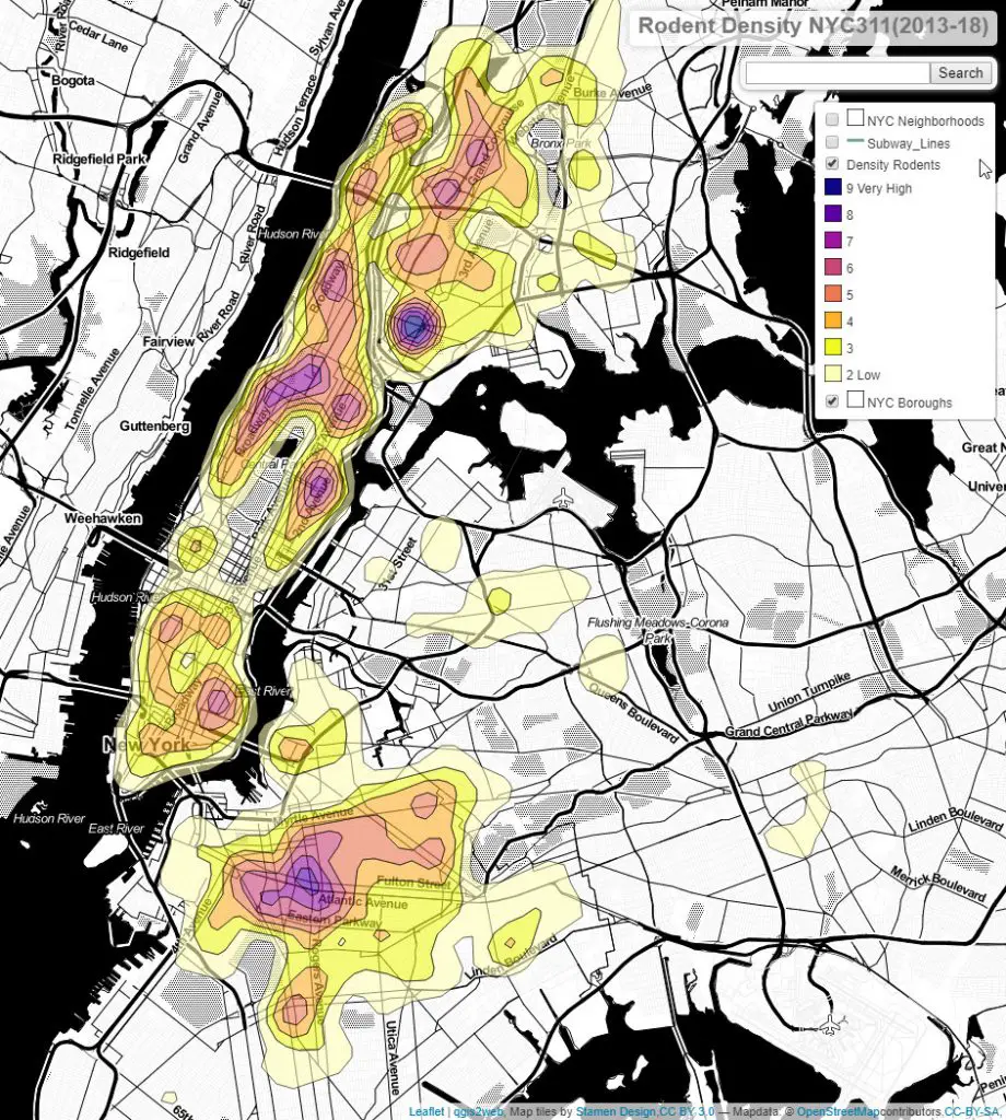
8. The Rodent Density Map: NYC’s Underground Residents
Where do New York City’s most notorious residents – the rats – make their homes? Based on over 90,000 rodent-related complaints, this revealing map shows the hotspots of rodent activity across the city. From subway stations to restaurant-dense areas, discover which neighborhoods deal with the most unwanted visitors and how urban features influence rodent populations. The findings have helped shape the city’s approach to pest control and sanitation policies.
Explore NYC’s rodent density patterns
More Maps to Come!
Our journey through New York City’s cartographic landscape is far from over. Stay tuned as we continue to add more maps that offer unique perspectives on the Big Apple. From historical charts to futuristic projections, each new addition will provide another piece of the puzzle that is New York City.
Explore Further with NYC Maps on Amazon
Want to take your New York City map exploration offline? Check out these fantastic map resources available on Amazon:
- New York City Five Borough Atlas
- Streetwise Manhattan Map
- New York City Subway Map
- New York City Atlas
- New York City Maps
Whether you’re planning a visit, conducting research, or simply fascinated by the city’s geography, these maps offer a wealth of information and visual appeal.
As we continue to update this post with new and intriguing maps of New York City, we invite you to join us on this cartographic journey through the streets, boroughs, and hidden corners of the Big Apple. Each map tells a story, and together, they paint a vivid picture of one of the world’s most captivating cities.