Open any flight tracking website and watch planes move across a flat map. Most flights don’t take what looks like the shortest route between cities. They curve around. They take long detours. Some paths look unnecessarily complicated.
There’s a good reason for this. Actually, seven good reasons.
Let’s look at a specific example. The map below shows the shortest possible routes from London to two cities in New Zealand. Auckland sits 18,336 kilometers (11,394 miles) from London. Dunedin is even farther at 19,086 kilometers (11,859 miles).
Here’s where it gets weird. New Zealand sits almost directly opposite London on the globe. They’re nearly antipodal points. When two places are on opposite sides of Earth, multiple routes can be equally short.
Think about it this way. Imagine a tiny ring around the North Pole, maybe 10 miles wide. Put two points on opposite ends of that ring. Now trace the shortest paths from those points down to the South Pole. Even though the two points started just 10 miles apart, their shortest paths would cut through opposite sides of the planet.
That’s what’s happening with London and New Zealand. Because they’re close to being exact opposites on the globe, the shortest routes fan out in different directions.
A flight following one of these routes would take roughly 22 to 23 hours of continuous flying. But most commercial flights don’t even follow these theoretically shortest paths. They deviate even more, sometimes by hundreds of miles. The map below shows why.
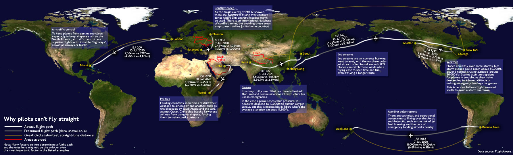
It occurs for the following reasons:
Air traffic control: To keep planes from getting too close, especially in busy airspace such as the North Atlantic, air traffic controllers organize flights onto invisible ‘highways’ known as airways or tracks.
Terrain: It is risky to fly over Tibet, as there is limited flat land and communications infrastructure for emergencies. In the case a plane loses cabin pressure, it needs to descend to 10,000ft (3.05 km) to sustain oxygen levels, but this is impossible in Tibet, where the average elevation exceeds 14,800ft (4.51 km).
Jet streams: Jet streams are air currents blowing west to east, with the northern polar jet stream often found around 60°N. Planes can catch these winds while flying east to save time and fuel, even if flying a longer route.
Avoiding polar regions: There are technical and operational constraints to flying over the Arctic and Antarctic, such as the risk of jet fuel freezing and the lack of emergency landing airports nearby.
Weather: Planes could fly over some storms, but storm clouds could reach above 60,000ft (18.29 km), beyond the average erasing altitude (around 30,000 ft (9.14 km)). Winds also limit options for planes in trouble. They make descending to a lower altitude or making emergency landings dangerous.
Politics: Feuding countries sometimes restrict their airspace to the airlines of one another, such as the blockade by Saudi Arabia and the UAE against Qatar. China also blocks Taiwanese airlines from using its air, forcing them to make costly detours.
Conflict zones: As the tragic events of MH 17 showed, there are dangers to flying over conflict zones where anti-aircraft missiles might be used. There is an international database of conflict zones, but avoiding these areas is up to each airline.

 Airlines for Domestic Flights—By State")


