The Best World Map Posters in 2026
A world map poster can be practical, decorative, or educational.
I looked at 26 different options. Below you’ll find everything from cheap laminated maps to vintage 1400s-1800s cartography to modern canvas art. Each listing includes ratings, exact size, and current price.
(If you want a push-pin map for tracking travels, I wrote a separate comparison here since those deserve their own guide.)
Classic map posters
These are your workhorses. Practical, accurate, built for daily reference. Think laminated surfaces that work with dry-erase markers, updated geopolitical boundaries, and projections designed to minimize distortion.
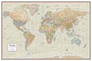
Maps International World Wall Map (33″ x 47″)

What happens when expert cartographers focus on both accuracy and aesthetics? This large-format political map uses different colors for each country, adds hill shading for topographic context, and includes time zone markers. The front lamination creates a write-on, wipe-clean surface perfect for classrooms or planning offices. First published in 1996 but updated annually, it reflects 2026’s geopolitical realities.
Rating: 4.8/5 (7,018 reviews)
Key Features: Write-on laminate, hill shading, time zones, annual updates
Size: 33″ x 47″ (84 x 119 cm)
Price: $28.99
View on Amazon
2-Pack Laminated World & USA Map Set with Equal Earth Projection

The Equal Earth projection corrects size distortions that plague Mercator maps. Africa appears at its true 30.3 million square kilometers (11.7 million square miles), not shrunken to Greenland’s proportions. This set includes both world and USA maps, each with 3-mil lamination that resists tears and stains. The waterproof edge seal handles spills without damage.
Rating: 4.8/5 (2,481 reviews)
Key Features: Equal Earth projection, double-sided lamination, waterproof seal, true continent sizes
Size: 18″ x 29″ (45.7 x 73.7 cm)
Price: $9.97
View on Amazon
Laminated World Map Poster (Blue Edition)

Sometimes simplicity wins. This updated map features clearly labeled countries and cities against bold blue oceans. The waterproof laminate means you can use it in kitchens, outdoor learning spaces, or anywhere moisture might be a concern. At under $10, it’s an accessible option for multiple rooms or classrooms.
Rating: 4.7/5 (3,177 reviews)
Key Features: Waterproof laminate, bold color scheme, transportation hubs
Size: 18″ x 29″ (45.7 x 73.7 cm)
Price: $9.97
View on Amazon
Swiftmaps Contemporary Premier Wall Map (24″ x 36″)
This is where cartographic detail meets visual depth. The Contemporary Premier series uses Miller Projection to reduce polar distortion, then adds 3D ocean and land topographic shading that creates genuine visual interest. Made in the USA and printed on heavyweight paper with both-sides lamination, it’s compatible with wet or dry-erase markers. The earth-tone color palette works in professional settings without looking overly academic.
Rating: 4.7/5 (424 reviews)
Key Features: Miller Projection, 3D topographic shading, double-sided lamination, dry-erase compatible, Made in USA
Size: 24″ x 36″ (61 x 91.4 cm)
Price: $18.90
View on Amazon
Maps with Alternative Projections
If you want to get away from the standard Mercator view, these projections show continents at their true sizes. No more oversized Greenland.
Updated Peters Projection World Map (36″ x 24″)

The Peters projection corrects size distortions so countries appear in accurate proportion to each other. This updated version from South of Kings includes current country names, cities, and bodies of water. The 1.7-mil lamination on both sides makes it waterproof and dry-erasable. Used by UNESCO, schools, and NGOs specifically because it shows Africa, South America, and other regions at their actual sizes.
Rating: 4.7/5 (189 reviews)
Key Features: Accurate country proportions, dry-erase surface, waterproof lamination, UNESCO-approved
Size: 36″ x 24″ (91.4 x 61 cm)
Price: $34.99
View on Amazon
Gall Orthographic World Map (36″ x 24″)

Another equal-area projection that fixes Mercator’s distortions. Africa appears 14 times larger than Greenland, as it actually is. Designed by a family-run map company with 30 years in business, printed on 36lb paper with archival inks and 1.7-mil lamination on each side. The color palette uses soothing tones that work well in classrooms or offices.
Rating: 4.5/5 (702 reviews)
Key Features: True-size continents, satin-finish lamination, up-to-date labels, Made in USA
Size: 36″ x 24″ (91.4 x 61 cm)
Price: $34.99
View on Amazon
World Map Posters for Kids
These maps combine accuracy with visual elements designed for children. Illustrated animals, landmarks, bright colors, and durable materials that survive enthusiastic handling.
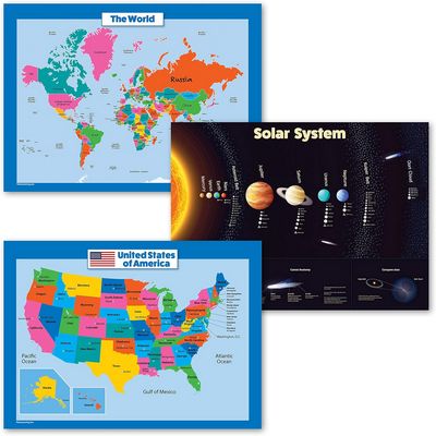
3-Pack: USA & World Map + Solar System Poster Set
This educational trio includes a USA map, world map, and solar system poster. All with 18″ x 24″ dimensions and 3-mil lamination. The clear fonts and vibrant colors make learning accessible, while the tear-resistant design handles classroom intensity. Over 2,000 customers rate it 4.8/5 for good reason.
Rating: 4.8/5 (2,099 reviews)
Key Features: Three-poster educational set, 3-mil lamination, tear-resistant, clear fonts
Size: 18″ x 24″ (45.7 x 61 cm) each
Price: $12.97
View on Amazon
2-Pack Illustrated World & USA Maps for Kids

Children learn better when abstract concepts connect to recognizable images. These maps feature cartoon-style animals (pandas, elephants, kangaroos) at their geographic locations, plus landmarks like the Eiffel Tower and pyramids. The USA map shows state capitals and national symbols including the bald eagle. The double-sided lamination with waterproof edge seal makes these genuinely spill-proof.
Rating: 4.8/5
Key Features: Animal illustrations, landmark icons, state symbols, waterproof seal
Size: 18″ x 29″ (45.7 x 73.7 cm)
Price: $12.97
View on Amazon
Vintage & Historical Map Reproductions
These reproductions capture the artistry and scientific thinking of different eras. From Gleason’s 19th-century flat Earth map to Urbano Monte’s circular 1587 projection.
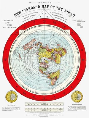
Gleason’s New Standard Map of the World (1892)
This restoration of Alexander Gleason’s 1892 map represents a specific moment in cartographic history. Whether you’re interested in the flat Earth “theory” it depicts or simply appreciate its azimuthal equidistant projection centered on the North Pole, it’s a conversation piece. Includes a free eBook of Samuel Rowbotham’s “Zetetic Earth Not A Globe” for historical context.
Rating: 4.6/5 (307 reviews)
Key Features: Historical reproduction, azimuthal projection, includes companion eBook
Size: 18″ x 24″ (45.7 x 61 cm)
Price: $24.95
View on Amazon
Cavallini & Co. Decorative World Map Sheet
Printed on Cavallini’s signature Italian archival paper, this 20″ x 28″ sheet works for multiple purposes. Wall art, gift wrapping, or craft projects. The vintage aesthetic comes from their extensive archives, and the archival paper quality ensures longevity. At $6.99, it’s accessible enough to buy multiples for creative projects.
Rating: 4.6/5 (235 reviews)
Key Features: Italian archival paper, versatile use, vintage design
Size: 20″ x 28″ (50.8 x 71.1 cm)
Price: $6.99
View on Amazon
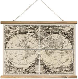
XIAOAIKA Vintage Nautical Chart with Wood Frame
This reproduction captures the aesthetic of maritime exploration’s golden age. Celestial illustrations, nautical symbols, ornate borders. The non-removable solid wood hanger with hanging rope means it arrives ready to display. Printed on high-quality linen for texture and durability, it brings historical depth to offices or studies.
Rating: 4.7/5 (90 reviews)
Key Features: Solid wood frame, linen material, nautical symbols, ready to hang
Size: 39″ x 29″ (99 x 73.7 cm)
Price: $34.90
View on Amazon
16th Century Johannes Schnitzer Ptolemy Map (1482)
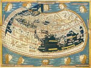
This reproduction of a 1482 map shows the double-hemisphere design and cartographic thinking that defined Renaissance geography. Printed on thick 240gsm matte paper with a non-reflective finish, it fits standard 16″ x 12″ frames available anywhere. Perfect for history educators or anyone interested in how Europeans understood world geography before global exploration.
Rating: 5.0/5 (4 reviews)
Key Features: Renaissance cartography, 240gsm matte paper, standard frame size
Size: 16″ x 12″ (40.6 x 30.5 cm)
Price: $6.99
View on Amazon

Urbano Monte’s 1587 World Map Reproduction
Urbano Monte’s circular projection centered on the North Pole represents Renaissance cartography at its most ambitious. This meticulous reproduction includes latitude/longitude grids, decorative windheads, and the hypothetical southern landmasses geographers imagined before Antarctica’s discovery. Printed on heavyweight matte paper and available up to 44″ x 44″, it makes a genuine centerpiece.
Rating: 4.4/5 (57 reviews)
Key Features: Circular polar projection, decorative windheads, multiple sizes, 192gsm paper
Size Options: 16″ x 16″ to 44″ x 44″ (40.6 to 111.8 cm)
Price: $34.99
View on Amazon
17th Century Antique World Map with Nautical Elements
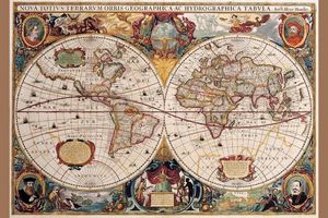
This reproduction captures the ornate style of 17th-century cartography. Sailing ships, elaborate compass roses, decorative cartouches. Made in the USA on premium acid-free paper for fade resistance, it arrives rolled in a protective tube and fits standard 16″ x 24″ frames. Educational and decorative for classrooms or homes.
Rating: 4.2/5 (62 reviews)
Key Features: Acid-free paper, fade-resistant, standard frame size, Made in USA
Size: 16″ x 24″ (40.6 x 61 cm)
Price: $16.99
View on Amazon
Historical Timeline Map Posters
How do you visualize thousands of years of human history? These timeline posters use color-coded bands, vertical or horizontal layouts, and synchronological methods to show the rise and fall of civilizations across millennia.
Adams Synchronological Chart of History (23 feet!)

Based on James Ussher’s “Annals of the World,” this reproduction of Sebastian Adams’ 1871 chart spans 6,000 years from Creation (dated to 4004 BC) through the late 19th century. The 21 fold-out panels can be viewed as a book or extended to a continuous 23-foot timeline. With full-color illustrations and handwritten commentary, it synchronizes biblical and world history in a format that helps contextualize concurrent events (like seeing the Twelve Tribes of Israel alongside the rise and fall of ancient empires.
Rating: 4.8/5 (2,598 reviews)
Key Features: 6,000-year scope, biblical integration, 23-foot length, fold-out panels, hardcover
Size: 27″ x 276″ (68.6 x 701 cm) extended
Price: $44.96
View on Amazon
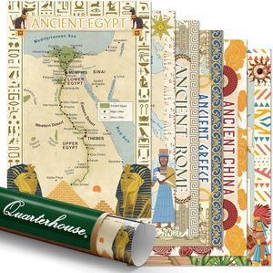
Quarterhouse Ancient Civilizations 6-Poster Set
This educational set covers Ancient Egypt, Mesopotamia, Rome, Greece, China, and Mesoamerica across six 12″ x 18″ posters. Designed specifically for K-12 classrooms and printed on high-grade satin paper in the USA, each poster provides geographic and temporal context for understanding how these civilizations overlapped and influenced each other.
Rating: 4.5/5 (79 reviews)
Key Features: Six civilization posters, educational design, satin paper, Made in USA
Size: 12″ x 18″ (30.5 x 45.7 cm) each
Price: $29.99
View on Amazon
World History Timeline

This horizontal timeline uses color-coded bands to show territorial reach of empires from 3000 BC to 2000 AD. Each civilization’s “width” reflects its influence at different time periods, with annotations for key events like the fall of Rome or the Industrial Revolution. The laminated finish protects it from classroom wear.
Rating: 4.4/5 (777 reviews)
Key Features: Color-coded empires, 5,000-year scope, territorial representation, laminated
Size: 30.3″ x 20.9″ (77 x 53.1 cm)
Price: $16.99
View on Amazon
Histomap: 4,000 Years of World History (17″ x 77″)

Originally published in 1931, this vertical timeline uses expanding and contracting color-coded bands to show the relative power of civilizations from 2000 BC to 1900 AD. When the British Empire was at its peak, its band widens. When Rome fell, its band narrows and eventually disappears. This visual representation of power dynamics makes abstract historical concepts immediately graspable.
Rating: 4.4/5 (125 reviews)
Key Features: Vertical timeline, power visualization, 1931 design, premium matte paper
Size: 17″ x 77″ (43.2 x 195.6 cm)
Price: $58.95
View on Amazon
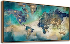
World Map Art Posters
Looking for decorative map art? These canvas options range from framed ready-to-hang pieces to multi-panel gallery walls.
Pogusmavi Large World Map Canvas with Frame (24″ x 48″)
This green-toned world map comes in a ready-to-hang format with solid wood dark frame. Printed on canvas with pre-installed hanging hardware, it requires no additional setup. The 24″ x 48″ size works well above sofas or in offices without overwhelming the space.
Rating: 4.7/5 (2,937 reviews)
Key Features: Wood frame included, pre-installed hardware, ready to hang
Size: 24″ x 48″ (61 x 121.9 cm)
Price: $115.90
View on Amazon
BoxColors Watercolor Beige Map Multi-Panel Set (30″ x 70″)
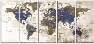
This five-panel canvas set (each panel 30″ x 14″) creates an expansive 30″ x 70″ display in watercolor beige tones. The push-pin compatible surface lets you track travels across the extra-large format. Comes with 1.5″ depth framing and pre-installed hanging hardware. Perfect for filling large walls in living rooms or offices.
Rating: 4.8/5 (53 reviews)
Key Features: Five-panel design, push-pin compatible, watercolor aesthetic, ready to hang
Size: 30″ x 70″ (76.2 x 177.8 cm) overall
Price: $159.00
View on Amazon
BoxColors Blue Beige Map 3-Panel Set (30″ x 60″)
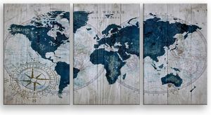
A slightly smaller three-panel option (each panel 30″ x 20″) in blue and beige tones. The old map aesthetic combines vintage cartography elements with modern canvas printing. Like their other sets, it includes pre-installed hanging hardware and 1.5″ depth frames.
Rating: 4.7/5 (87 reviews)
Key Features: Three-panel design, vintage aesthetic, framed, ready to hang
Size: 30″ x 60″ (76.2 x 152.4 cm) overall
Price: $119.00
View on Amazon
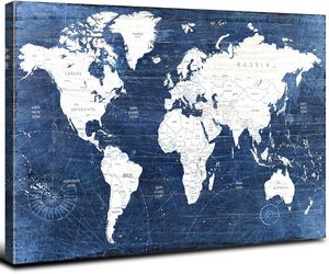
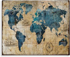
AREBOLO Navy Blue Vintage Map Canvas (16″ x 24″)
This single-panel canvas combines vintage map design with modern navy blue coloring. Printed with high-definition giclee technology on waterproof, UV-resistant canvas, it’s wrapped on a wooden frame with hook mount ready to hang. The smaller 16″ x 24″ size works well in bedrooms, offices, or as part of a gallery wall.
Rating: 4.6/5 (471 reviews)
Key Features: Giclee printing, UV-resistant, waterproof canvas, ready to hang
Size: 16″ x 24″ (40.6 x 61 cm)
Price: $35.99
View on Amazon
Stupell Industries Abstract World Map (16″ x 20″)
This gallery-wrapped canvas features a vintage abstract interpretation of world geography. Printed in the USA with high-quality inks and hand-stretched over a 1.5″ thick wooden frame, it arrives ready to hang with no hardware needed. The multi-color design works with various decor styles.
Rating: 4.6/5 (167 reviews)
Key Features: Gallery-wrapped, hand-stretched, Made in USA, ready to hang
Size: 16″ x 20″ (40.6 x 50.8 cm)
Price: $22.57
View on Amazon
Choosing a Map
So after comparing all these, here’s what I figured out.
Projection types. Most maps use Mercator (from 1569). Makes Greenland look about as big as Africa. Africa’s actually 14 times bigger. If you just like looking at maps, Mercator is probably what you’re used to seeing and it’s fine. But if you’re teaching geography or you want accurate continent sizes, get Equal Earth or Peters instead. They look different but show the real proportions. Worth seeing both types before deciding.
Laminated vs not. For classrooms, get laminated. Kids touch maps constantly. You can mark on laminated ones with dry-erase markers and wipe them off. Regular paper maps look better initially but fall apart with constant use.
Kids and illustrations. Younger kids ignore standard political maps. Put cartoon animals on the continents and suddenly they pay attention. Illustrated versions work better through about age 10. Older students can use regular maps without needing the visual hooks.
Historical and vintage maps. These fall into two groups. First, you have historical timelines (Adams Chart showing 6,000 years on a 23-foot foldout, Histomap with expanding/contracting bands showing empire power over 4,000 years). These visualize time and civilizations. Second, you have old cartography reproductions (1587 Urbano Monte with North Pole at center, vintage nautical charts with sailing ships and compass roses). Neither type is geographically accurate by modern standards. Doesn’t matter though. You’re getting historical perspective or creating a specific look. History lovers like the timelines for understanding how civilizations overlapped. Travelers and people decorating offices tend to go for the vintage nautical aesthetic.
Canvas or paper. Paper maps are reference tools. Canvas versions are decorative. If you want something that looks like wall art rather than educational material, get canvas. Multi-panel sets work for large empty walls. Single panels fit into existing gallery arrangements.
The nautical look. Old maritime charts with ornate borders, compass roses, and sailing ships have a particular style. Good for offices or studies if you want that exploration/adventure atmosphere.
Figure out what you’ll actually do with it and that narrows things down fast.
How about Buckminster Fuller’s “Dymaxion” projection? At the very least it is more accurate than any other.
I could only find this map on Amazon:
Dymaxion Satellite postcard
https://amzn.to/3vIKY5Z
How do you say a map of the earth is accurate? What is your standard?
Why are there 53 diagonally colored areas and 7 rectangles around the perimeter of the Topological Map of United States?
The topologist’s map of the world – Vivid Maps
I suppose the rectangles to the right are Europe and Africa, and the rectangles on the bottom are Caribbean, Central and South American countries.