The Irish Potato Famine was a period of mass hunger in Ireland from 1845 to 1852. The most rigorously touched territories in the west and south of Ireland, where the Irish language was prevailing.
The famine’s supposed cause was a Phytophthora infestans that infected potato crops everywhere in Europe during the 1840s, causing an extra 100 thousand deaths outside Ireland and influencing much of the widespread European tension Revolutions of 1848. From 1846, the Phytophthora infestans’ impact was intensified by the British Whig government’s financial policy of laissez-faire capitalism. Additional reasons include the system of absentee landlordism and single-crop dependence.
The severest year of the period was 1847, called “Black ’47”. About one million people died throughout the famine. Over one million more left Ireland, causing the country’s population to fall by approximately 20 percent. In some settlements, the population decreased by as much as 67 percent. Between 1845 and 1855, over 2 million Irish emigrated.
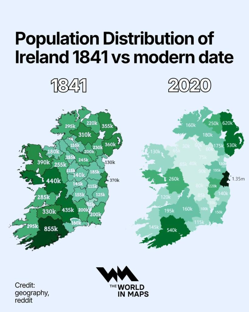
These 1841 and 2020 population maps created by The World in Maps, show something remarkable. Mayo: 390,000 then, 130,000 now. Fermanagh: 310,000 to 180,000. Tipperary: 235,000 to 160,000. Cork held up better proportionally—855,000 to 540,000. Dublin went the opposite way: 440,000 to 1.35 million.
Why did some counties lose so much more than others? The western counties relied heavily on potatoes, so the famine hit them hardest. But the continued population loss over 180 years? That’s about jobs. The west never developed industries or diverse agriculture like Cork did. Dublin became Ireland’s economic center. Generation after generation, young people left for opportunities elsewhere. They still do.


")

