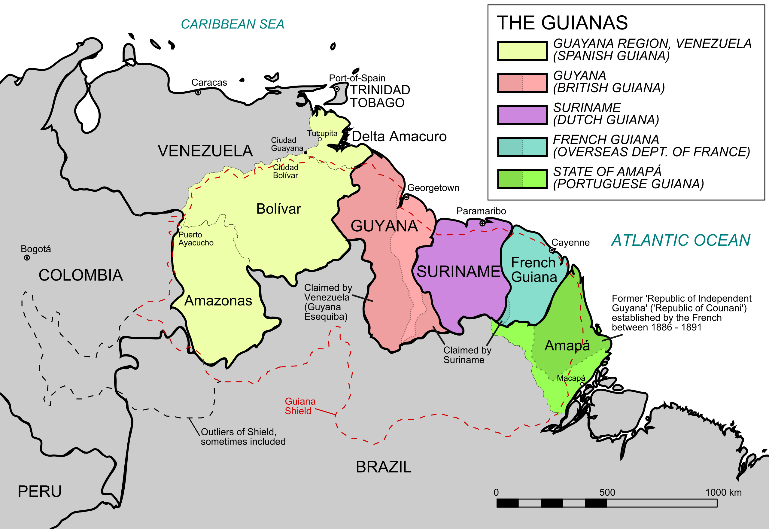
If you trace the northern edge of South America, you reach a long, river-carved coastline that Europeans once divided five different ways: Spanish Guiana, British Guiana, Dutch Guiana, French Guiana, and Portuguese Guiana (now Amapá in Brazil). The map below, created by Reddit user u/APrimitiveMartian, shows all these five Guianas.
The word Guiana comes from indigenous languages spoken along this coast. Most scholars think it means something like “land of many waters” — and when you look at a map, that makes perfect sense. Rivers pour out of the interior, the coastline is laced with estuaries, and wetlands stretch for miles. European explorers heard the local name in the 1500s and started using it themselves.
What happened to the Five Guianas
These five labels started as overlapping colonial claims along the same coastal strip. Through the 1800s and 1900s, some became countries while others got folded into their larger neighbors. Let me walk you through what happened to each one:
Spanish (Venezuelan) Guiana — Spain grabbed the westernmost chunk of coast. After Venezuela broke free in the early 1800s, that territory simply got absorbed into the new republic. You won’t find “Spanish Guiana” on any modern map — it’s just part of Venezuela now, including areas like Delta Amacuro and chunks of Bolívar state.
British Guiana → Guyana (1966) — The British took over some old Dutch settlements along three rivers: Essequibo, Demerara, and Berbice. They stitched them together into one colony called British Guiana. That name lasted until 26 May 1966, when independence arrived and the country became Guyana.
Dutch Guiana → Suriname (1975) — The Dutch hung onto their piece much longer. Their colony finally gained independence on 25 November 1975 and took the name Suriname.
French Guiana — still French — Here’s the outlier. French Guiana didn’t go independent. Instead, in 1946, France reclassified it from a colony to an overseas department. It’s legally France – same status as any department in mainland Europe.
Portuguese / Brazilian Guiana → Amapá — Portugal’s claim on the far eastern edge became Brazilian when Brazil itself formed. The area sparked a nasty border dispute with France in the late 1800s — the so-called “Amapá Question” — but international arbitration around 1900 settled things in Brazil’s favor. Today it’s the state of Amapá.
Short summary
Most of those colonial “Guiana” labels vanished as the modern map took shape. Guyana and Suriname won independence and kept variations of the name. French Guiana stayed French. The Spanish and Portuguese zones melted into Venezuela and Brazil.
")


