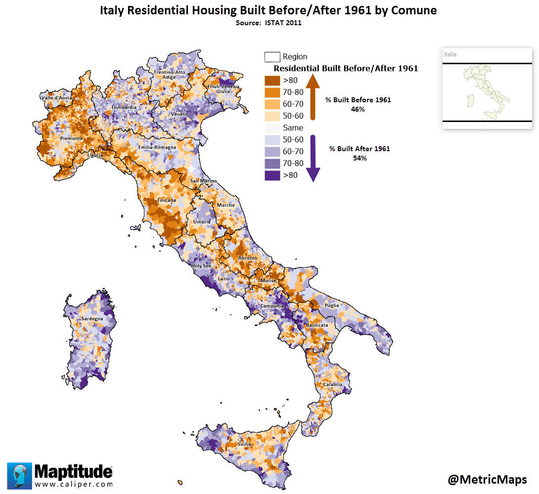
The map below tells a fascinating story about Italy’s architectural heritage and modern development. Each comune (municipality) is colored to show whether most of its residential buildings were constructed before or after 1961 – a pivotal year that marks a transformation in Italian housing.
This map created by @MetricMaps reveals striking regional patterns that reflect Italy’s complex social and economic history. The historic centers of major cities like Rome, Florence, and Venice show a predominance of pre-1961 structures, preserving their architectural heritage. In contrast, many suburban areas and smaller cities display significant post-1961 development, telling the story of Italy’s great economic boom.
The year 1961 wasn’t chosen arbitrarily. It represents the height of Italy’s “Economic Miracle” (Il Boom Economico), a period of unprecedented growth and urbanization from the late 1950s through the early 1960s. During this time, Italy transformed from a largely agricultural society into a major industrial power, triggering massive population shifts and urban expansion.
Several patterns stand out on the map:
Historic City Centers: The cores of major cities often show concentrations of pre-1961 buildings, reflecting Italy’s preservation of its historic urban fabric
Suburban Growth: Rings of post-1961 development surround many cities, showing patterns of urban expansion
Regional Variations: Northern Italy generally shows more post-1961 development, reflecting its stronger industrial growth
Coastal Development: Many coastal areas show significant post-1961 construction, coinciding with the rise of tourism
Looking closer at the data reveals the scale of Italy’s post-war transformation. The 1950s and 1960s saw the construction of millions of new homes as Italians moved from rural areas to cities seeking industrial employment. This period also marked the rise of Italy’s middle class, with families finally able to afford their own homes rather than living in multi-generational households.
The pattern of development had lasting effects on Italian society. Many historic city centers became prestigious addresses, while the rapidly-built suburbs of the 1960s now face challenges of aging infrastructure and needed renovations. Understanding these patterns helps explain current property values, urban planning challenges, and preservation efforts across Italy.
This map, created by @MetricMaps, provides valuable insights for urban planners, preservationists, and anyone interested in understanding how Italy’s communities evolved during one of its most transformative periods.