Americans are mostly dependent on the car. More than 150 million workers, that’s at least 120 million vehicles, appear on U.S. streets every day.
A vast majority of American commuters, totaling 73%, rely on their personal vehicles for their daily commute between home and work, establishing it as the overwhelmingly preferred mode of transportation. In contrast, public transportation is utilized by only 13% of the 7,649 respondents, while 11% opt for biking as their commuting choice.
Below are maps that reflect the major aspects of transportation use by American commuters.
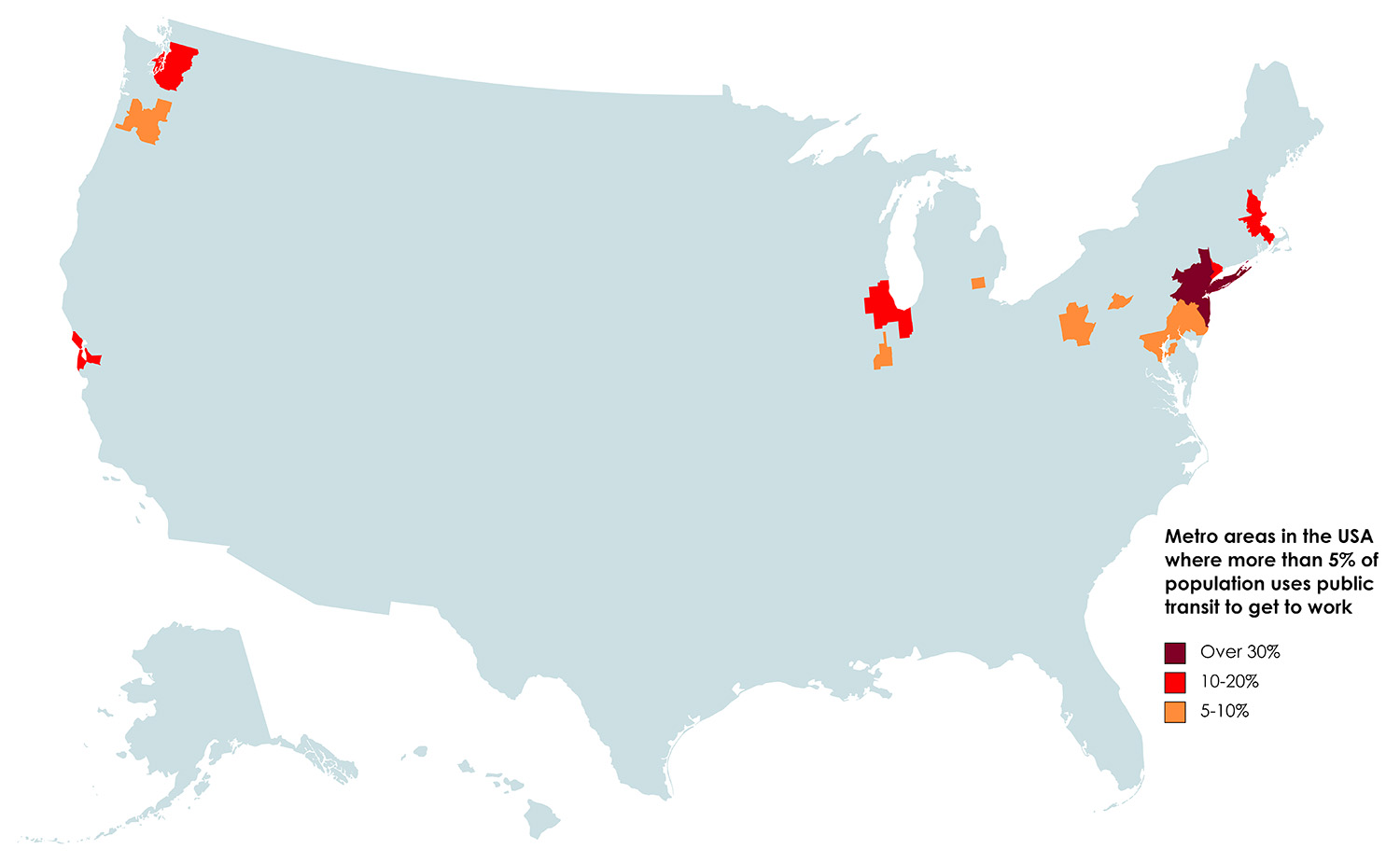
Approximately 13 percent of American commuters use public transit as their mode of transportation to get to work. But in the New York metropolitan area, more than 30% of the population uses public transit daily to get to work.
The map below shows metro areas in the USA where more than 5% of the population uses public transit to get to work.
Crossing State Borders: Out-of-State Commuters
Several states in the U.S. stand out for having a significant percentage of out-of-state commuters. These states often share characteristics, such as proximity to major metropolitan areas or employment hubs, which attract workers from neighboring regions. Washington, D.C., for instance, sees a notable influx of commuters from Maryland and Virginia due to its status as the nation’s capital. New Jersey, thanks to its proximity to New York City and Philadelphia, also draws a substantial number of out-of-state workers. In addition, Delaware and Maryland experience a considerable share of out-of-state commuters, driven by their accessibility to nearby states and major employment centers like Wilmington and the Baltimore-Washington metropolitan area. These states’ percentages of out-of-state commuters reflect the interconnectedness of regional economies and the flexibility of today’s workforce.
The map below shows the percentage who work outside the state of residence.
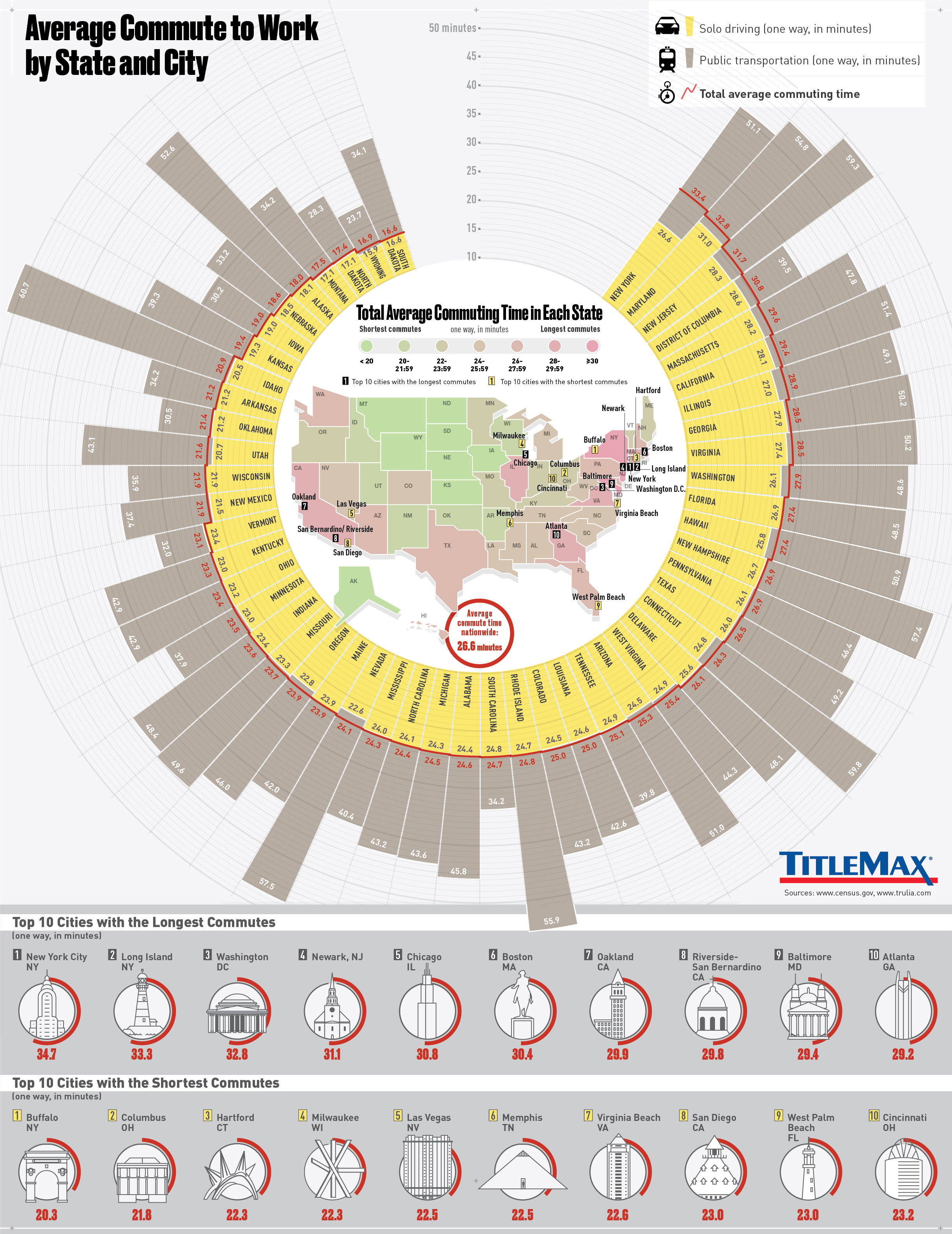
Average commute to work by U.S. state and city
The average commute time in the United States varies by state and city. On a national level, the average commute time is around 27 minutes. However, in major metropolitan areas like New York City, Los Angeles, and Washington, D.C., commuters often experience longer commute times, typically exceeding 30 minutes. In contrast, states with less congested traffic, like South Dakota or Montana, tend to have shorter average commutes, often under 20 minutes.
Top ten cities with the longest commutes (one way, in minutes) 1. New York City, NY – 34.7 2. Long Island, NY – 33.3 3. Washington, DC – 2.8 4. Newark, NJ – 31.1 5. Chicago, IL – 30.8 6. Boston, MA – 30.4 7. Oakland, CA – 29.9 8. Riverside-San Bernardino, CA – 29.8 9. Baltimore, MD – 29.4 10. Atlanta, GA – 29.2
Top ten cities with the shortest commutes (one way, in minutes) 1. Buffalo, NY – 20.3 2. Columbus, OH – 21.8 3. Hartford, CT – 22.3 4. Milwaukee, WI – 22.3 5. Las Vegas, NV – 22.5 6. Memphis, TN – 22.5 7. Virginia Beach, VA – 22.6 8. San Diego, CA – 23.0 9. West Palm Beach, FL – 23.0 10. Cincinnati, OH – 23.2
The map below shows the percentage of US commuters traveling more than 45 minutes to work by U.S. county.
@MetricMaps
Percent daytime population change due to commuting by U.S. county
The percent daytime population change due to commuting in U.S. counties can vary widely. Generally, during weekdays, many urban and suburban counties experience a substantial increase in population as commuters from surrounding areas travel in for work, causing a daytime population surge. In some highly populated counties or major metropolitan areas, this increase can be significant, with daytime populations exceeding nighttime populations by 10-30% or more. In contrast, in rural or less densely populated counties, the daytime population change due to commuting may be relatively minimal, often resulting in a small percentage increase during the day.
@MetricMaps
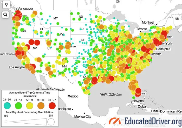
The lifetime cost of commuting by car
The lifetime cost of commuting by car can be substantial and includes various expenses such as vehicle purchase, fuel, maintenance, insurance, and depreciation. The total cost depends on factors like the length of the commute, the fuel efficiency of the car, and local fuel prices. Over a lifetime, these costs can add up to tens of thousands or even hundreds of thousands of dollars. Additionally, the time spent commuting by car can have indirect costs, including lost productivity and negative health impacts due to stress and sedentary behavior.
The average American will spend 408 days, $108,727 on gas and vehicle maintenance costs associated with commuting while driving 173,203 miles to and from work in their of their life.
The lifetime cost of commuting by car in major U.S cities ranges from $67,154 [in Stockton, California] to $182,886 [in Atlanta, Georgia] (60.8 cents per mile for the average sedan when gas, insurance, and maintenance costs are considered). The average American puts in 45 years of working 250 days per year.
Below is another attempt by the howmuch.net team to estimate the cost of the American Commute, using the U.S. Bureau of Economic Analysis.
According to the U.S. Bureau of Economic Analysis, Americans spend between $2,000 and $5,000 per year on their daily commutes, depending on the state. North Dakota has the highest average commuting expenses in the U.S.
Top 10 U.S. states with the most expensive yearly commutes
North Dakota: $5,059.11
Wyoming – $4,393.4
New York – $3,710.71
Minnesota – $3,660.54
Michigan – $3,631.39
Nebraska – $3,623.30
New Hampshire – $3,601.70
South Dakota – $3,597.75
New Jersey – 3,519.25
Massachusetts – 3,368.87
Top 10 U.S. states with the most expensive yearly commutes
West Virginia – $2,003.81
Mississippi – $2,141.44
Alabama – $2,178.2
Kentucky – $2,200.03
Tennessee – $2,222.31
North Carolina – $2,243.04
Florida – $2,269.36
Arkansas – $2,327.42
Nevada – $2,390.62
Lousiana – $2,395.07
If you liked these maps, you may also be interested in the following map posters: