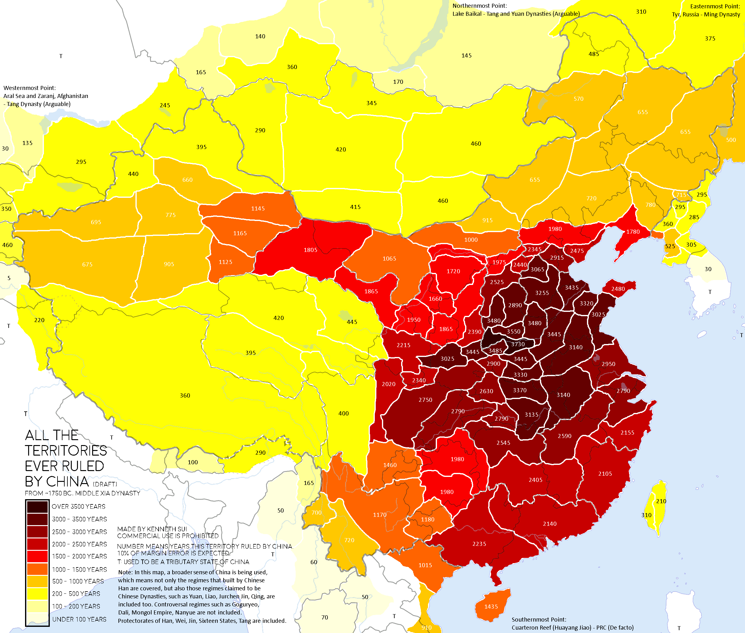
How long has China ruled over Tibet? Was Vietnam ever part of the Chinese empire? And just how far west did Chinese dynasties once stretch? Those questions—and many others—come into focus with a map created by Reddit user KennethSui, who visualized all the territories ever ruled by China from around 1750 BC to the modern era.
The map color-codes regions by the number of years each area was under Chinese control. The darker the red, the longer the rule, up to over 3,500 years in the Central Plain, while areas like Kazakhstan or South Siberia (including Lake Baikal) saw only brief rule or tribute-based influence.
From a River Valley to a Continental Power
China’s recorded territorial history starts with the Shang Dynasty (c. 1600–1046 BC), centered around the Yellow River. Early Chinese states were small, mostly confined to what is now Henan and Shanxi provinces. These were agricultural heartlands, and they remained core areas of Chinese civilization throughout history.
The Qin Dynasty (221–206 BC) was the first to unify China under a centralized imperial government, standardizing weights, roads, and even script. But it was the Han Dynasty (206 BC – 220 AD) that really expanded Chinese borders, reaching into modern-day Vietnam, Korea, and Central Asia. The famous Silk Road began to emerge during this period, connecting China with Persia and Rome.
The Tang and Yuan: China at Its Largest
China’s Tang Dynasty(618–907 AD) was one of its most outward-looking. The map shows how far west Tang forces went, as far as present-day Afghanistan and the Aral Sea. This was the high point of China’s cultural influence in Central Asia, and Chinese rule over parts of the Tarim Basin and even modern-day Kyrgyzstan lasted for centuries.
Under the Yuan Dynasty (1271–1368), led by Mongol rulers like Kublai Khan, China reached its broadest boundaries. That’s when it held areas like Tibet, Mongolia, parts of Russia, and Siberia, though not always under direct bureaucratic control. Some of these regions were vassals or allies rather than fully integrated provinces.
The Ming and Qing: Expansion, Consolidation, and Collapse
The Ming Dynasty (1368–1644) pulled back slightly from the Yuan’s enormous reach but remained strong in Korea, Vietnam (for a time), and the South China Sea. The brief occupation of the Ryukyu Islands and influence over Southeast Asia can also be seen on the map. Still, most of the Ming focus was on consolidating internal control after overthrowing Mongol rule.
The Qing Dynasty (1644–1912), ruled by the Manchu, expanded westward aggressively. This was the era when Tibet, Xinjiang, and Inner Mongolia were brought more firmly under the imperial fold. Qing armies went as far as Nepal, and China claimed suzerainty over parts of Kokand and Kazakhstan (source).
By the end of the Qing, though, China was exhausted, losing territory to colonial powers and facing internal rebellions. After 1912, the Republic of China and later the People’s Republic of China (from 1949) would inherit a patchwork of provinces that more closely resemble today’s borders.
Not Just Direct Rule, but Tributaries Too
Most of the areas on the map were actually ruled by China at one time or another. But a few others had more of a diplomatic relationship than direct control. Vietnam, Korea, and parts of Southeast Asia weren’t part of China, but they sometimes sent tribute or showed symbolic respect to the Chinese emperor, usually to keep trade flowing or avoid conflict. They stayed independent, but kept those ties when it made sense.They stayed independent, but the connection was still there. It wasn’t the same as being part of the empire, but those ties still had political weight back then.
Vietnam, in particular, was ruled by China for centuries before eventually gaining independence, though even after that, it sometimes maintained tribute ties.
In contrast, places like Uzbekistan and Russia’s Far East only came under Chinese control briefly, often during frontier campaigns.
It’s worth noting that Japan is not shown on this map, and rightly so. While Japan occasionally participated in the Chinese tribute system (notably during the Muromachi period, 14th–16th centuries), it was never under Chinese rule.
What the Map Tells Us About History and Geography
This map doesn’t just show which places were under Chinese rule—it also highlights how political geography can stretch and shrink over time. China’s geography is a living record of dynasties rising and falling, of diplomacy and warfare, and of the constant negotiation between center and frontier.
And while much of this expansion happened centuries ago, many of these regions are still geopolitically significant today. Disputes over Tibet, Taiwan, Xinjiang, and the South China Sea can trace their roots to some of the historical dynamics shown on this map.