The Mississippi River Mapped
The Mississippi has the 4th largest basin globally and ranks as the 4th longest river (3,730 km/2,320 mi) and 15th biggest river by the volumetric flow rate of water on the planet (average discharge 16,800 m3/s or 593,000 cu ft/s).
From its beginning of Lake Itasca in northern Minnesota, the Mississippi River regularly flows through the heart of America to the south for 2.3 thousand miles (3,730 km) to the delta in the Gulf of Mexico.
Table of Contents
The Mississippi River basin
The river passes through the U.S. states of Minnesota, Wisconsin, Iowa, Illinois, Missouri, Kentucky, Tennessee, Arkansas, Mississippi, Louisiana.
The principal tributaries of the Mississippi River are Arkansas, Illinois, Missouri, Ohio, and the Red rivers. The map below shows the major tributaries of the Mississippi river system.

The Mississippi River has the second-largest drainage system on the North American continent (after the Hudson Bay drainage system). The map below shows the 7,000 rivers that feed into the Mississippi.

With its numerous streams, the Mississippi’s watershed drains thirty-two states and two Canadian provinces.
Mississippi road map
Of hundreds of tributaries of the Mississippi River, 45 are navigable for at least 50 miles (80 kilometers), giving a system of waterways that surpasses 15 thousand miles in length. The main riverbed of the Mississippi River is navigable from the Falls of Saint Anthony (Minneapolis) to the Gulf of Mexico (Louisiana).

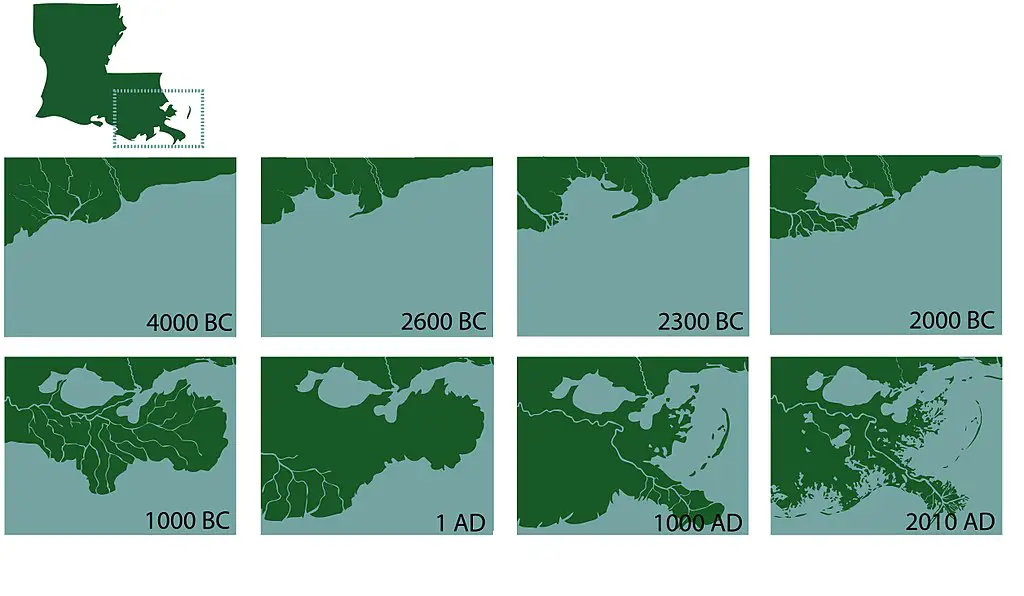
Typically, Mississippi changes its course every thousand years. The last time she changed course was in 1000 AD. The mouth of the river also changed its shape significantly.
Mississippi River Delta through history
Below are the historic maps of the Mississippi River.
Strip map of the Mississippi River (1866)
1866 strip map presenting 2600 miles of the Mississippi River from its delta to its source at Lake Itasca

Horizontal view of the Mississippi River (1673)


Ame Rica will soon be divided by water