James K. Polk, the 11th President of the United States, served from 1845 to 1849. Born in 1795 in North Carolina, Polk rose through the political ranks in Tennessee before becoming president. Known as “Young Hickory,” he was a protégé of Andrew Jackson and shared his mentor’s expansionist views.
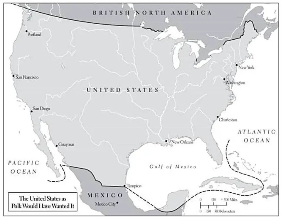
Polk’s presidency was marked by ambitious plans to expand the United States’ territory. His vision for the country would dramatically alter the map of the United States, pushing its borders from coast to coast.
Here’s another version of the map of the United States as James Polk would have wanted, but showing state boundaries.
President Polk’s Realized Expansionist Plans
James K. Polk’s presidency was defined by his successful efforts to dramatically expand the map of the United States. His realized plans reshaped the nation’s borders, stretching from the Atlantic to the Pacific and nearly doubling its size. Let’s explore these territorial acquisitions:
Annexation of Texas
The annexation of Texas was a cornerstone of Polk’s expansionist agenda. Texas had declared independence from Mexico in 1836, operating as the Republic of Texas for nearly a decade. Polk strongly supported bringing Texas into the Union, despite the contentious nature of the issue.
The annexation was controversial for several reasons. Many worried about the expansion of slavery into new territories, as Texas was likely to enter the Union as a slave state. There were also concerns about potential conflict with Mexico, which still claimed Texas as its territory.
Despite these challenges, Polk endorsed the cause. The annexation process was actually completed shortly before he took office, but Polk embraced it as a significant achievement of his administration. On December 29, 1845, Texas was formally admitted to the Union as the 28th state, significantly altering the southwestern portion of the United States map.
Oregon Territory
The Oregon Territory dispute was another major focus of Polk’s expansionist policies. At the time, the Pacific Northwest was jointly occupied by the United States and Great Britain, an arrangement that had been in place since 1818.
During his presidential campaign, Polk used the slogan “Fifty-Four Forty or Fight,” referring to latitude 54°40′ north. This aggressive stance suggested he was willing to go to war with Britain to secure the entire Oregon Territory for the United States.
However, once in office, Polk took a more diplomatic approach. Negotiations with Britain led to a compromise that avoided war while still securing a significant portion of the disputed territory for the United States.
The Oregon Treaty, signed on June 15, 1846, established the border between U.S. and British territory at the 49th parallel. This agreement gave the United States control over the present-day states of Oregon, Washington, and Idaho, as well as parts of Wyoming and Montana. The settlement of the Oregon question filled in a large section of the northwestern United States map, extending American territory to the Pacific coast.
Mexican-American War and the Mexican Cession
The most dramatic and consequential of Polk’s territorial acquisitions came as a result of the Mexican-American War. Following the annexation of Texas disputes over the southern border of the new state led to increased tensions with Mexico.
Polk, seeking to provoke a conflict that could lead to further territorial gains, sent American troops into the disputed area between the Nueces River and the Rio Grande. This action led to fights with Mexican forces, which Polk used as justification to ask Congress for a declaration of war in May 1846.
The Mexican-American War lasted until 1848 and ended with a decisive American victory. The conflict concluded with the signing of the Treaty of Guadalupe Hidalgo on February 2, 1848. This treaty resulted in Mexico ceding a vast swath of territory to the United States, an area that became known as the Mexican Cession.
The Mexican Cession dramatically reshaped the map of the United States, adding approximately 525,000 square miles to the country. This massive acquisition included all or parts of several present-day states:
California
Nevada
Utah
Arizona
New Mexico
Colorado
Wyoming
This territorial gain extended U.S. borders to the Pacific Ocean fulfilled the concept of “Manifest Destiny,” and set the stage for the country’s emergence as a continental power.
The impact of these acquisitions on the map of the United States cannot be overstated. In just four years, Polk’s aggressive expansionist policies had stretched the nation’s borders from coast to coast, nearly doubling its size and setting the foundation for much of the modern-day United States map.
However, not all of Polk’s territorial ambitions came to fruition. He desired to annex Cuba and surrounding areas, viewing them as natural extensions of U.S. territory. These plans remained unrealized during his presidency.
Polk’s Legacy: A Nation Redrawn
In just four years, James K. Polk had reshaped the map of the United States more dramatically than any president before or since. His aggressive expansionism fulfilled the lofty ideal of “Manifest Destiny,” but at a steep cost in blood and diplomatic goodwill.
The map that emerged from Polk’s presidency was barely recognizable from the one he inherited. The United States had morphed from a coastal republic into a transcontinental juggernaut, poised to become a world power. Every time we gaze at a modern map of the United States, we’re looking at the indelible fingerprints of James K. Polk – the president who redrew a nation.
These maps serve as visual reminders of the country’s expansion and the pivotal role Polk played in shaping its boundaries.