Snow continuously has challenged humans but also has attracted and fascinated us. It changes the landscape around us, even altering the sounds we hear and the odors we breathe. For some, the expectation of coming snowstorms is like for Santa Claus on Christmas. But the charm and delight ever are compensated by anxiety and danger.
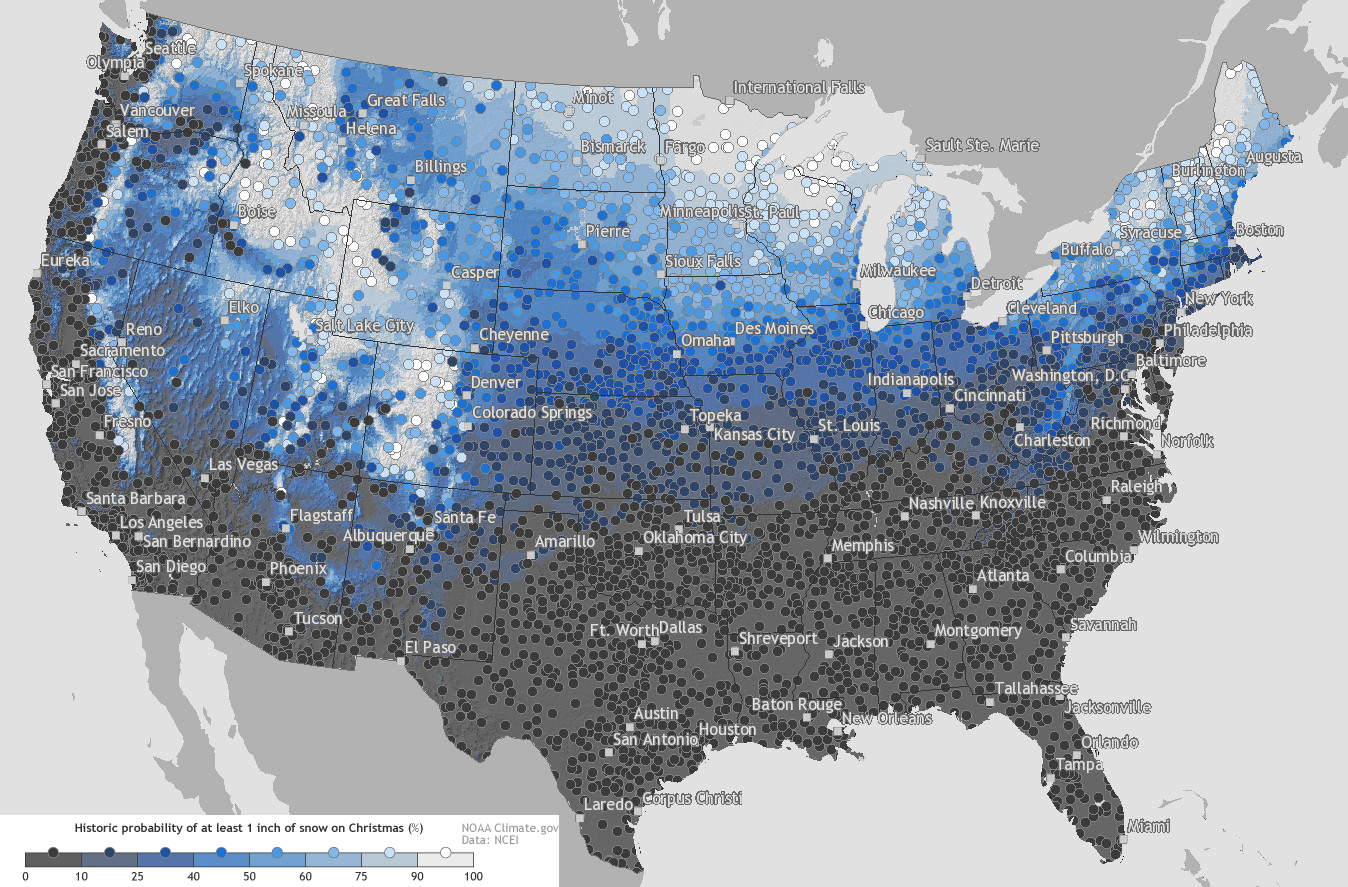
Historic probability of at least 1-inch snow on Christmass (%)
Nowadays, as in the yore, primary life responsibilities such as securing food, staying dry and warm, and doing daily activity become more complicated when deep snow is occurring. Moving, whether by foot, car, train, or aircraft, is particularly vulnerable.
How much snow it typically takes to cancel school in the United States
Alexander Trubetskoy
Snow is an invaluable resource that affects the nationwide economy. It gives life-giving water. In much of the mountain West, between 60-75% of the annual precipitation comes in snow, 1/5 of yearly precipitation in the North Greats Plain comes as snow.
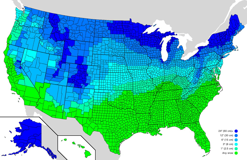
Average annual snowfall by U.S. county
Reddit user: Spooderman89
An increasing preponderance of the United States populations now resides in areas that get very little snowfall. But every year, millions of Americans move to some of the country’s snowest regions and spend hundreds-of-millions of bucks to engage in the snow to ski. Hundreds-of-thousands of others move southward away from the white Great Lakes, New England, and the Upper Midwest.
In November, you might observe snow on the peaks of western mountains, in a strip over southern Canada and the Nothern Plains in the protection of the Great Lakes, and along the ridges of the northern Appalachian chain. Next, constant snow covering extends outward above mountains and descending into plains, raised plateaus, and valleys.
First snow dates in the U.S.
Snows will get the Northeast shoreline and reach some northern Pacific shores in Washington, Oregon, California, once or twice before wintertime winds.
Snow coverage ever is irregular with consideration to latitude, elevation, aspect, and slope. For example, the West Coast is usually snowless as far north as southern Canada, while territories east of the Cascades have snow spreading south (into the Great Basin).
In warmer latitudes south of 40° north latitude, snows commonly exist temporarily as a single layer from one snowstorm.
Snow depth varies greatly from year to year. The map below shows daily snow depth for the continental United States from January 1, 1950, through December 31, 2015.
The map below shows the total seasonal snowfall in the continental United States (2017 – 2018).
Cumulative snowfall this season in the United States visualized as relief
Snowiest U.S. Weather Stations
The mount chains that defend North America’s west coast from Alaska southward to northern California comprise the most snowiest places. But each U.S. State has its snowiest place. Weather stations may not be supported in all of the snowiest places, but possibly that will improve in the years to come.
Rank
State
Place
Average annual snowfall
Elevation
1
Washington
Mt. Rainier
645.5 inches (1,640 cm)
5,430 feet (1,660 m)
2
Utah
Alta
456.9 inches (1,161 cm)
8,730 feet (2,660 m)
3
Oregon
Crater Lake
453.4 inches (1,152 cm)
6,470 feet (1,970 m)
4
California
Soda Springs
411.6 inches (1045 cm)
6,885 feet (2,099 m)
5
Alaska
Valdez
314.1 inches (798 cm)
95 feet (29 m)
6
New Hampshire
Mt. Washington
282.1 inches (717 cm)
6,270 feet (1,910 m)
7
Colorado
Climax
273.8 inches (695 cm)
11,350 feet (3,460 m)
8
Wyoming
Burgess Junction
257.8 inches (655 cm)
8,050 feet (2,450 m)
9
New York
High Market (West Turin)
214.2 inches (544 cm)
1,816 feet (554 m)
10
Michigan
Herman
214 inches (540 cm)
1,667 feet (508 m)
11
Vermont
Mt. Mansfield
211.9 inches (538 cm)
3,866 feet (1,178 m)
12
Idaho
Island Park
211.8 inches (538 cm)
6,298 feet (1,920 m)
13
South Dakota
near Lead
195.9 inches (498 cm)
6,120 feet (1,870 m)
14
Montana
Mystic Lake
184.3 inches (468 cm)
6,560 feet (2,000 m)
15
West Virginia
Terra Alta
175.0 inches (444 cm)
2,582 feet (787 m)
16
Wisconsin
Hurley
162.2 inches (412 cm)
1,500 feet (460 m)
17
New Mexico
Red River
151.1 inches (384 cm)
8,661 feet (2,640 m)
18
Maine
Eustis
123.8 inches (314 cm)
1,163 feet (354 m)
19
Arizona
Bright Angel Ranger Station
118.4 inches (301 cm)
8,320 feet (2,540 m)
20
Nevada
Wild Horse Reservoir
118.2 inches (300 cm)
6,265 feet (1,910 m)
21
Maryland
Oakland
105.9 inches (8.83 ft)
2,408 feet (734 m)
22
Ohio
Chardon
109.2 inches (277 cm)
1,291 feet (393 m)
23
Pennsylvania
Erie
103.0 inches (262 cm)
650 feet (200 m)
24
North Carolina
Mt. Mitchell
91 inches (230 cm)
6,684 feet (2,037 m)
25
Minnesota
Duluth
86.5 inches (220 cm)
651 feet (198 m)
26
Tennessee
Mt. Le Conte
82.9 inches (211 cm)
6,345 feet (1,934 m)
27
Connecticut
Norfolk
77 inches (200 cm)
1,167 feet (356 m)
28
Massachusetts
Ashburnham
75.1 inches (191 cm)
1,028 feet (313 m)
29
Indiana
South Bend
66.8 inches (170 cm)
752 feet (229 m)
30
Rhode Island
North Foster
60.4 inches (153 cm)
707 feet (215 m)
31
Virginia
Wise
52.7 inches (134 cm)
2,436 feet (742 m)
32
North Dakota
Fargo
51.6 inches (131 cm)
903 feet (275 m)
33
Nebraska
Harrisburg
46.5 inches (118 cm)
4,492 feet (1,369 m)
34
Iowa
Dubuque
42.5 inches (108 cm)
708 feet (216 m)
35
New Jersey
Sussex
41.2 inches (105 cm)
500 feet (150 m)
36
Illinois
Chicago
38.5 inches (98 cm)
858 feet (262 m)
37
Kansas
McDonald
37.6 inches (96 cm)
3,364 feet (1,025 m)
38
Kentucky
Closplint
31.7 inches (81 cm)
1,551 feet (473 m)
39
Oklahoma
Boise City
30.8 inches (78 cm)
4,175 feet (1,273 m)
40
Missouri
Edina
22.0 inches (56 cm)
795 feet (242 m)
41
Delaware
Wilmington
21.9 inches (56 cm)
114 feet (35 m)
42
Texas
Stratford
20.2 inches (51 cm)
3,699 feet (1,127 m)
43
Arkansas
Gravette
16.0 inches (41 cm)
1,211 feet (369 m)
44
South Carolina
Caesars Head
7.2 inches (18 cm)
3,180 feet (970 m)
45
Alabama
Valley Head
6.1 inches (15 cm)
1,043 feet (318 m)
46
Georgia
Dallas
3.8 inches (9.7 cm)
994 feet (303 m)
47
Mississippi
Hickory Flat
2.9 inches (7.4 cm)
435 feet (133 m)
48
Louisiana
Shreveport
0.8 inches (2.0 cm)
225 feet (69 m)
49
Florida
Milton
0.2 inches (0.51 cm)
9 feet (2.7 m)
50
Hawaii
--
0.0 inches (0 cm)
--
Quick facts:
The expense of snow clearing for streets and roadways across the United States surpasses $2 billion yearly.
8 million tons of salt at the cost of approximately $250 million is spread on roads.
Tens-of-thousands of road accidents and personal slip-and-fall occurrences still happen that claim lives and cause hundred-of-millions of dollars in medicinal expenses.
The maximum 24-hour snowfall in the U.S. is an extraordinary 75.8 inches at Silver Lake (elevation of 10.360 feet in the peaks west of Boulder, Colorado). It occurred on April 14-15. 1921. The snowfall in 12 months at an official weather station was 1.122 inches throughout the 1971-72 winter at the Mount Rainier Paradise Ranger Station.
Buffalo in New York state is a close runner-up in U.S. big cities with the most snow. A 39-inch snowfall in 24 hours in early December 1995 cost the city nearly $5 million for snow cleaning.
Every year, a mean of 105 snowstorms hit the continental U.S.
In the western U.S., mountain snows provide up to 75% of all-year-round surface waler supplies.
Nationwide, the common snowfall amount per day when snow falls is approximately 2 inches, but in few West mountain territories, an average of 7 inches per snowy day is recorded.
Rochester in New York state averages 94 inches of snow Annual and is the snowiest large city in the United States (population: 204,000). The annual municipal snow-removal budget of the city is approximately $4 million.


 rated fast-food chains across the United States")

