The location of state capitals in the United States exhibits a variety of geographic patterns and considerations. These patterns can be influenced by historical, economic, political, and geographical factors.
Many state capitals are strategically located to ensure relatively easy accessibility from various parts of the state. This centrality helps to facilitate government operations and make it convenient for residents and officials from different regions to reach the capital.
The Distance of States’ Capitals From Their Geographical Centers
The capital of New Jersey, Trenton, is located closest to the geographic center of the state. The distance from Trenton to the geographical center of the state is only 5 miles or 8 kilometers.
Reddit user: Apricall
U.S. State capital located most distant from their geographical center:
Some state capitals are situated near major cities or economic centers. This may be due to the historical significance of certain urban areas, as well as the desire to connect government functions with economic activities.
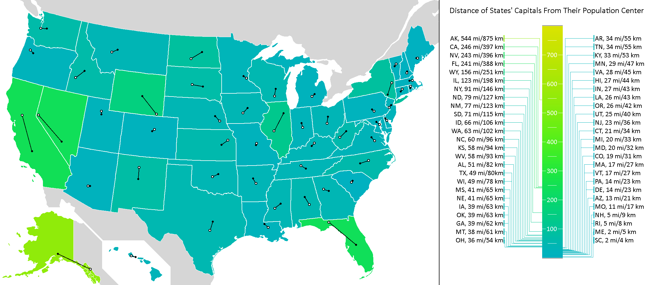
Distance of States’ capitals from their centers of population
Columbia, the capital city of South Carolina, is located closest to the state’s center of population. The distance from the city of Colombia to the state’s center of the population of the state is only 2 miles or 4 kilometers.
Reddit user: Apricall
U.S. State capital located most distant from their population center:
There are some spelling and geographic errors but it is an interesting geographic discussion. Cheyenne WY is in 2nd place, not Madison WI.
J Kerski
3 years ago
Juneau AK is the capital city of AK, not Anchorage.
Jerold
2 years ago
Come on. It has been 4 years since people have been sending you corrections. Fix the webpage! This does not make you look very smart and I do not trust the rest of your information.


Ankoridge? Medison?
Juneau is the capital of Alaska. Madison is the capital of Wisconsin.
you tell em
There are some spelling and geographic errors but it is an interesting geographic discussion. Cheyenne WY is in 2nd place, not Madison WI.
Juneau AK is the capital city of AK, not Anchorage.
Come on. It has been 4 years since people have been sending you corrections. Fix the webpage! This does not make you look very smart and I do not trust the rest of your information.