Asia is huge. You can see that in how wildly its climates vary. Siberia’s Arctic coast gets tundra. Central Russia has vast subarctic forests. Arabia and central Asia have deserts that bake under relentless sun. Southeast Asia gets rain constantly and stays warm all year. India and East Asia get monsoons—soaking wet in summer, dry in winter, the whole system flipping with the seasons.
What creates such extremes? The Himalayas run for thousands of kilometers, acting as this massive wall basically. Air coming from the south hits it and releases all its rain on India’s side, leaving Tibet really dry. Distance from the sea is key too – coastal spots stay milder with ocean moisture, while inland areas get extreme temps. Monsoons change course every season, dumping tons of rain in summer and leaving vast areas dry come winter. And yeah, Asia spans from nearly the Arctic Circle right down to the equator.
But these setups are changing now. I tracked how Asian climate zones have moved since 1930 and where they’re going by 2099 using data from Beck et al. (2023) at 1-kilometer resolution. The changes vary by region but add up to major reorganization. For climate codes and what they mean, check my earlier post on global classifications.
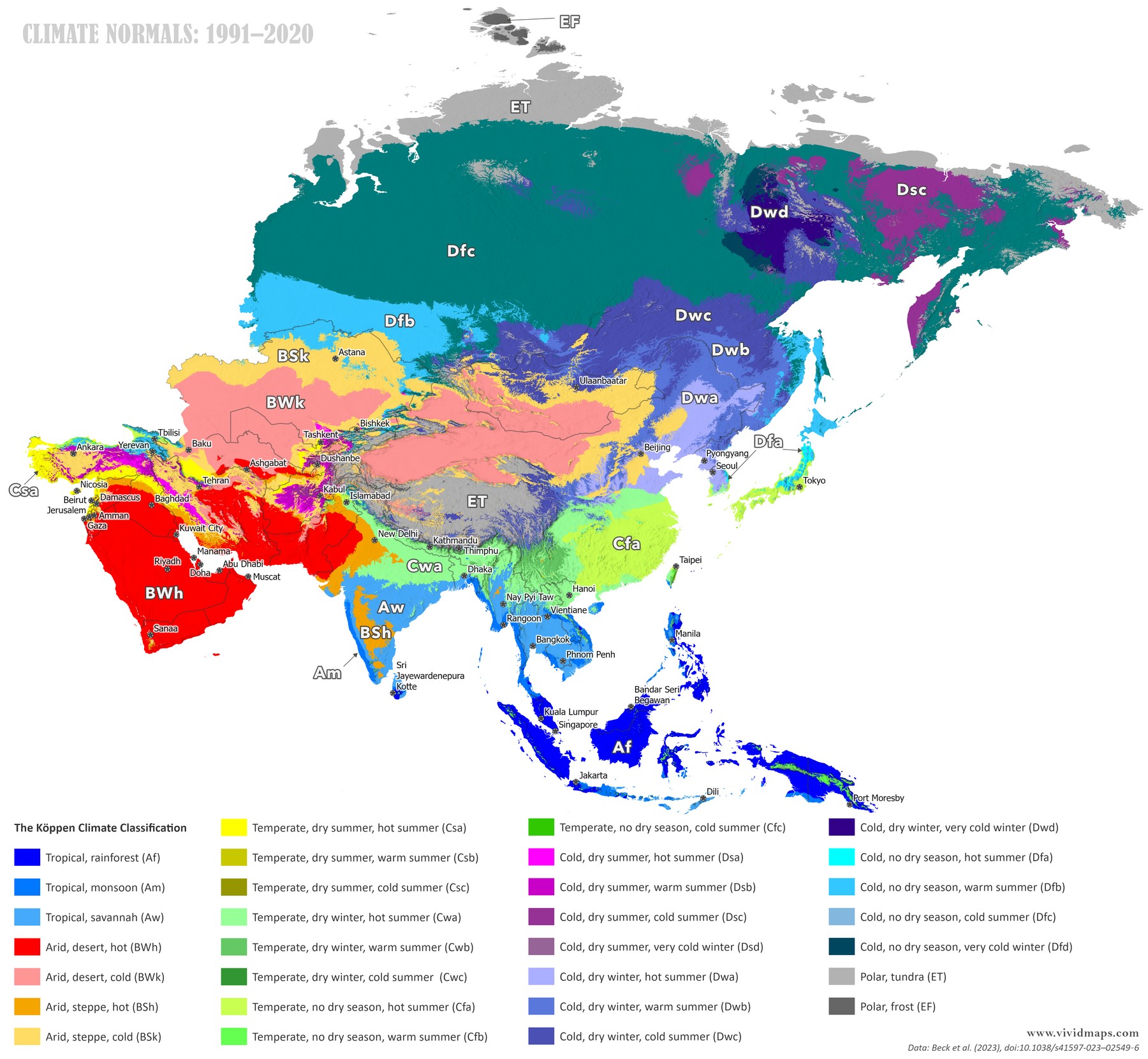
Current climate zones of Asia (1991–2020).
Today’s map shows Asia’s extremes. Up along the northern coast of Siberia, you’ve got Arctic tundra (ET), and the islands have polar ice (EF). Then there are these huge stretches in Siberia and northern Russia that are subarctic (stuff like Dfc, Dfd, Dwc, Dwd). Hot deserts (BWh) and cold deserts (BWk) fill Arabia, and chunks of central Asia. Tibet and Mongolia have cold desert and steppe (BWk, BSk). Southeast Asia and southern India hold tropical rainforest (Af). Those rainforests are bordered by savanna (Aw) and monsoon (Am) zones. Over in eastern China and bits of India, it’s humid subtropical (Cfa, Cwa). Then up north in China, along with Korea and Japan, things turn to humid continental (Dfa, Dfb, Dwa, Dwb).
You can see the Arctic tundra pulling away from Siberia’s coast.
Subarctic zones have retreated southward, replaced by warmer classifications moving north. Central Asian deserts have shifted their boundaries. The Tibetan Plateau has warmed, pushing some cold zones higher up. Tropical zones in Southeast Asia have seen their boundaries shift. Monsoon patterns have changed in timing and strength in some areas, affecting where climate boundaries fall.
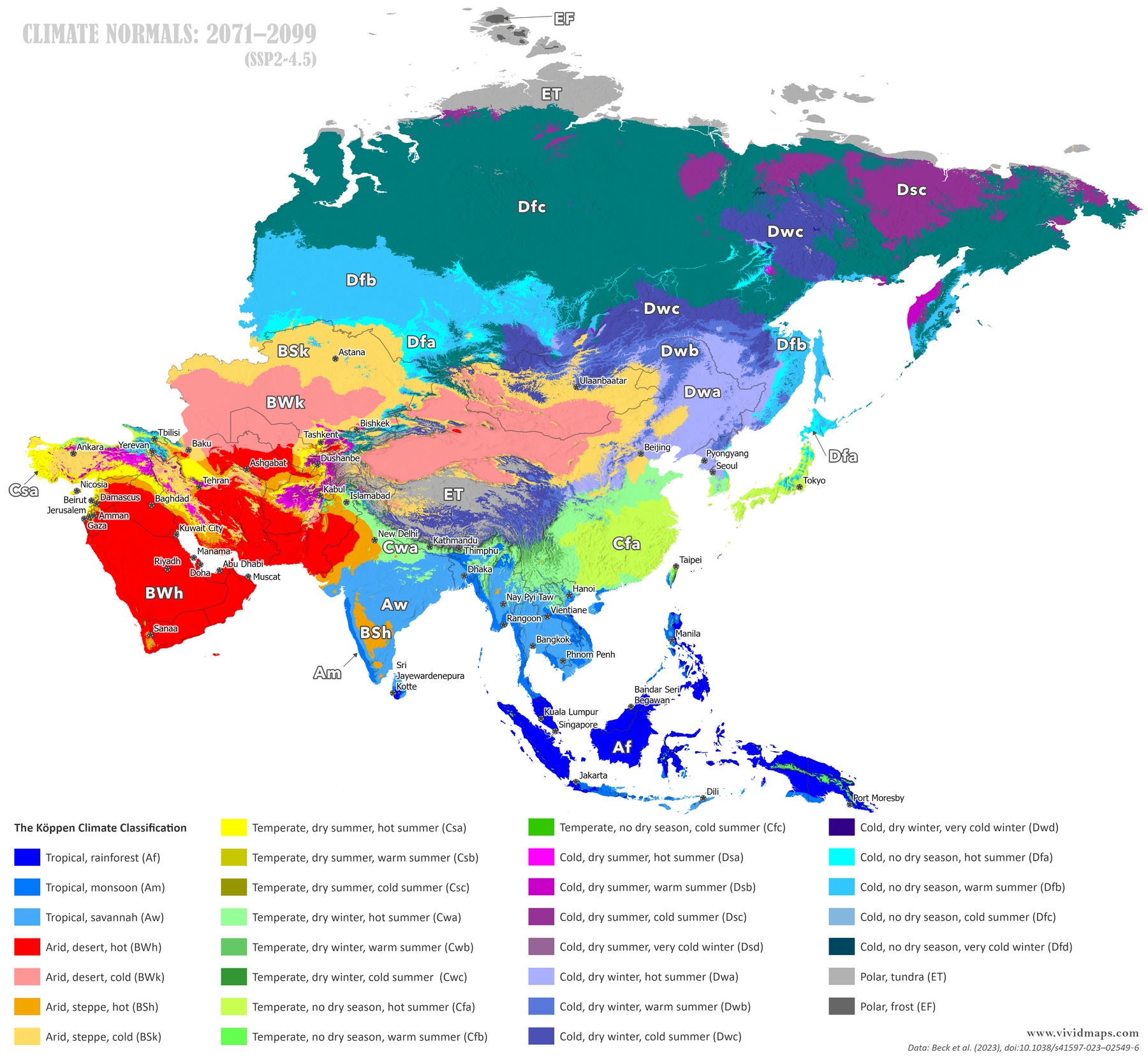
Projections to Century’s End
For the future, I used the SSP2-4.5 scenario where emissions plateau by mid-to-late century.
By 2099, changes come from multiple directions. Arctic tundra shrinks dramatically along Siberia’s coast, squeezed back to the northernmost strips and islands. Subarctic zones contract substantially, replaced by continental and temperate zones moving north. Desert zones in Arabia and central Asia expand in some areas. The Tibetan Plateau keeps warming, pushing cold zones to higher elevations where some just run out of mountain. Tropical zones show complex changes with some expansion and some areas drying out. Humid subtropical zones expand north in China. Continental zones in northern China and Mongolia shift toward warmer classifications.
Over this span, the reorganization is huge. Siberia’s coldest zones pull back hundreds of kilometers northward. What was tundra becomes subarctic. What was subarctic becomes continental. Central Asia sees complex changes in where deserts and steppes meet. The Himalayas and Tibet lose their coldest high-altitude zones as temperatures rise. Southeast Asia’s tropical climates shift along the edges where they meet other zones. East Asia’s subtropical zones expand northward into areas that were continental.
Billions of folks rely on these climate setups. Glaciers in the Himalayas supply water to major rivers such as the Ganges, Indus, Brahmaputra, Yangtze, and Mekong, which flow across nations including India, Pakistan, Bangladesh, China, and parts of Southeast Asia. Unfortunately, these glaciers are shrinking much faster now. Regions suitable for rice farming are relocating due to evolving temps and precipitation. In Siberia, permafrost is defrosting, releasing stored ancient carbon while making the soil unstable, leading to crumbling roads, pipelines, and structures. And deserts are slowly taking over arable land.
Monsoons might hit at unexpected times or dump unusual amounts, screwing up age-old farming routines. And species? They’re struggling to adapt in time.
I also threw together some maps for 1931–1960 and 2041–2070. Full sequence here:


?")
