An earthquake is a natural phenomenon characterized by the sudden release of energy in the Earth’s crust, leading to the generation of seismic waves that cause ground shaking. This release of energy typically occurs due to the movement of tectonic plates beneath the Earth’s surface. Earthquakes can vary in magnitude, from minor tremors that go unnoticed to devastating quakes capable of causing widespread destruction and loss of life. They often occur along fault lines or plate boundaries and can result in ground ruptures, tsunamis, landslides, and secondary hazards.
Major earthquakes have occurred since ancient times, but their observation and impact have not been evenly dispersed worldwide.
The two last most destructive earthquakes hit Turkey near the Syrian boundary on February 6, 2023. Both registered above a seven on the Richter scale and have a combined death toll fast growing past 20 thousand people.
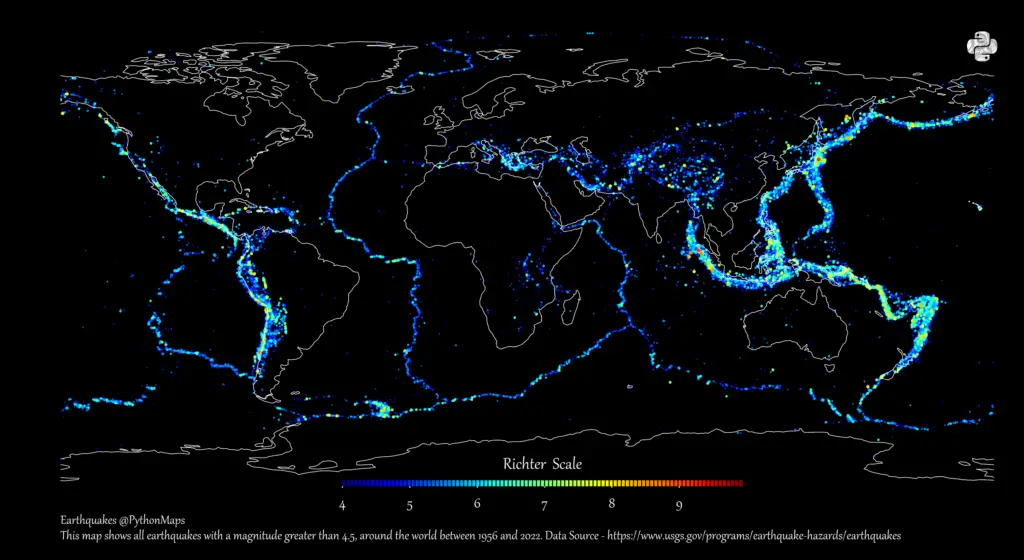
And glancing at the history of recent and ancient earthquakes, the place of these is no surprise. Using data from the United States Geological Survey, map maker PythonMaps mapped earthquake epicenters between 1956 and 2022 that documented a 4.5 or higher on the Richter scale.
The map vividly illustrates that t most earthquakes occurred at the boundaries of the Erth’s lithospheric plates. Here is an interactive version world map of earthquakes.
The most powerful earthquakes concentrated heavily around Pacific Plate. This cluster of volcanoes is known as the “Ring of Fire” for its ongoing volcanic activity, also driven by tectonic plate movement.
Here’s a list of the ten worst earthquakes in history:
Top 10 largest earthquakes in history
Rank
Name
Magnitude
Location
Date
1
Valdivia Earthquake
9.5
Bio-Bio (Chile)
May 22, 1960
2
Good Friday Earthquake
9.2
Alaska (United States)
March 28, 1964
3
2004 Indian Ocean Earthquake
9.1
Sumatra (Indonesia)
December 26, 2004
4
Tohoku Earthquake
9.1
Honshu (Japan)
March 11, 2011
5
1952 Severo-Kurilsk Earthquake
9.0
Kamchatka (Russia)
April 11, 1952
6
Maule Earthquake
8.8
Bio-Bio (Chile)
February 27, 2010
7
1906 Ecuador–Colombia Earthquake
8.8
Ecuador
January 31, 1906
8
Rat Islands Earthquake
8.7
Alaska, (United States)
February 4, 1965
9
Assam-Tibet Earthquake
8.6
Assam (Tibet/China)
August 15, 1950
10
2012 Indian Ocean Earthquake
8.6
Sumatra (Indonesia)
November 11, 2012
Fortunately, many of these large earthquakes occurred where few people lived.
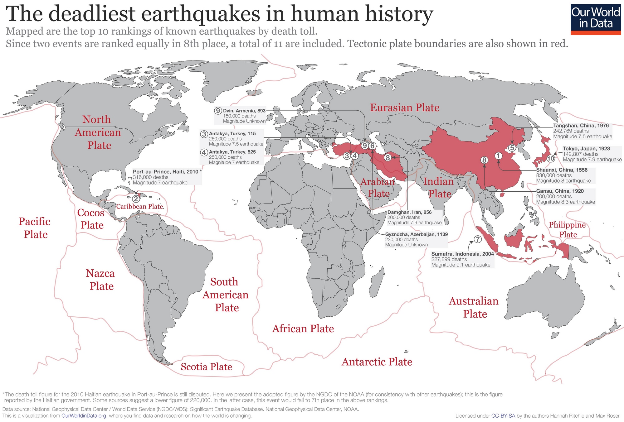
If you look at the entire history of documented earthquakes for about 4,000 years, the deadliest earthquake happened in China on January 23, 1556, in Shaanxi Province, which caused the deaths of 830,000 people.
The World map below, created by OurWorldinData, shows the top 10 known earthquakes by death toll rankings. Tectonic plate boundaries on the map are shown in red.
Top 10 deadliest earthquakes in human history
Rank
Location
Magnitude
Death toll
Year
1
Shaanxi, China
8.0
830,000
1556
2
Port-au-Prince, Haiti
7.0
316,000
2010
3
Antakya, Turkey
7.5
260,000
115
4
Antakya, Turkey
7.0
250,000
525
5
Tangshan, China
7.5
242,769
1976
6
Gyzndzha, Azerbaijan
Unknown
230,000
1139
7
Sumatra, Indonesia
9.1
227,899
2004
8
Damghan, Iran
7.9
200,000
856
9
Dvin, Armenia
Unknown
150,000
893
10
Tokyo, Japan
7.9
142,807
1923
Interesting facts about earthquakes
Our planet’s surface comprises 20 continually moving lithospheric plates. The pressure increase from shifting plates and can cause the crust to break. This break allows stress to be unleashed as energy, which moves through the earth in the form of waves.
Almost 80 percent of all the planet’s earthquakes happen in the “Ring of Fire” of the Pacific Ocean.
Each year, the southern California area has about 10 thousand earthquakes – most of which go unnoticed.
The largest earthquake ever registered was in Chile on May 22, 1960. It measured a magnitude of 9.5. It’s assessed to have killed over 3 thousand people and caused $550 million in damage (more than $5 billion in 2022, adjusted for inflation).
The largest documented earthquake in the U.S. was a magnitude 9.2 that struck Prince William Sound in Alaska on March 28, 1964.
Large earthquakes can shorten the length of a day as a result of a shift Earth’s axis
No one can predict an earthquake because the mechanisms that initiate earthquakes happen so far under the ground.
Want to learn more about earthquakes? Then you might like to read: