The Great Circuit: How 3 Highways Connect to Form a 27,000-Kilometer Loop Around China
Think about this for a moment: China shares borders with 14 countries and spans roughly the same area as the United States. Now imagine being able to drive around this entire massive country using just three highways. A fascinating discovery by Reddit user iantsai1974 shows exactly how this is possible, revealing one of the world’s most remarkable road systems.
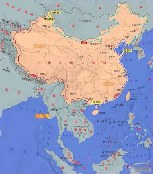
Three roads, sixteen provinces, and every landscape imaginable – from the scorching Taklamakan Desert to misty tropical forests. Together, these highways create a grand circuit of 27,000 kilometers (16,777 miles), taking around two months to complete. Let’s break down this epic journey and everything you need to know to make it happen.
Table of Contents
The Western Frontier: G219 – Where Few Travelers Venture
The adventure begins on National Highway G219, stretching 10,065 kilometers (6,254 miles) along China’s western border. This remarkable road holds the title of China’s longest national highway and offers some of the most spectacular – and challenging – driving conditions you’ll ever encounter.
Starting from the pristine Kanas Lake in northern Xinjiang, G219 winds through regions that seem frozen in time. You’ll pass ancient Silk Road towns where traditional markets still buzz with life, and climb to oxygen-thin heights as you cross the Tibetan Plateau. According to the Xinjiang Tourism Bureau, some sections of this road reach elevations above 5,000 meters (16,404 feet) – higher than many European Alps peaks.
The route takes you past the sacred Mount Kailash, where pilgrims have walked for thousands of years, and alongside the turquoise waters of Yamdrok Lake. As you continue south, the landscape transforms dramatically. The stark Tibetan plateau gives way to Yunnan’s subtropical valleys, where the Meili Snow Mountain stands guard over lush rainforests.
The Coastal Journey: G228 – From Tropical Beaches to Modern Metropolises
After the rugged western leg, G228 offers a complete change of pace. This 7,800-kilometer (4,847 mi) coastal highway connects the tropical south to China’s dynamic eastern seaboard. Beginning where G219 ends in Guangxi, this route showcases China’s maritime heritage and modern development.
You’ll cruise past the historic port of Xiamen, where the colonial-era architecture of Gulangyu Island tells stories of maritime silk roads. Further north, Hangzhou’s West Lake appears like a traditional Chinese painting come to life, especially during sunrise when mist hovers over its waters. According to China Daily, this section of the journey passes through cities that collectively generate over 40% of China’s GDP, offering a fascinating glimpse into the country’s economic miracle.
The route then takes you through Shanghai, where the historic Bund contrasts dramatically with futuristic Pudong. As you continue north, you’ll discover the remarkable coastal wetlands of Jiangsu, home to rare migratory birds and traditional fishing communities.
The Northern Arc: G331 – Through China’s Vast Wilderness
Completing the circuit, G331 cuts through China’s northern territories for 9,301 kilometers (6,779 mi). This section reveals yet another face of China – one of vast grasslands, dense forests, and ancient desert outposts.
Starting from the Korean border, the highway traverses the volcanic landscapes of Changbai Mountain, home to the supposedly mysterious Heaven Lake. Moving west, you’ll cross the endless Hulunbuir Grasslands, where the horizon seems infinite and traditional Mongolian culture thrives. The journey concludes at the ancient Silk Road city of Dunhuang, where the Mogao Caves house some of Buddhism’s most precious artistic treasures.
Making It Happen: Essential Planning Advice
A journey of this magnitude requires careful preparation. The complete circuit typically takes 45-60 days, though this can vary significantly based on your stops and pace. The best time to attempt this route is between May and September when mountain passes are open, though you’ll need to prepare for monsoon rains in the south and intense desert heat in the west.
Your packing list should prioritize safety and self-sufficiency. A high-clearance 4×4 vehicle is essential, particularly for the western section. You’ll need:
- A comprehensive vehicle maintenance kit
- Extra fuel containers for remote stretches
- High-altitude medication and an oxygen supply
- A satellite phone for emergency communications
Before setting out, ensure you have:
- A Chinese driver’s license or International Driving Permit
- Special permits for Tibet and border regions (allow 2-3 weeks for processing)
- Comprehensive travel insurance covering high-altitude regions
- A GPS device loaded with offline maps
Essential Maps and Resources
The following links are Amazon Affiliate links. As an Amazon Associate, I earn from qualifying purchases.
- National Geographic China Adventure Map
- Lonely Planet China Road Atlas
- National Geographic: China Classic Wall Map Poster
This circuit around China offers more than just impressive numbers – it’s a journey through time, culture, and landscapes that few travelers ever experience in a single trip. Whether you’re planning this adventure or just dreaming about it, these three highways reveal China in all its complexity and beauty.
Have you driven any part of this route? Share your stories in the comments below!


