The 1402 Kangnido Map: A Forgotten Masterpiece of Medieval World Geography
In the early 15th century, when most of the world was shrouded in mystery, Korean scholars created something extraordinary—a world map that would challenge everything we thought we knew about medieval cartography.

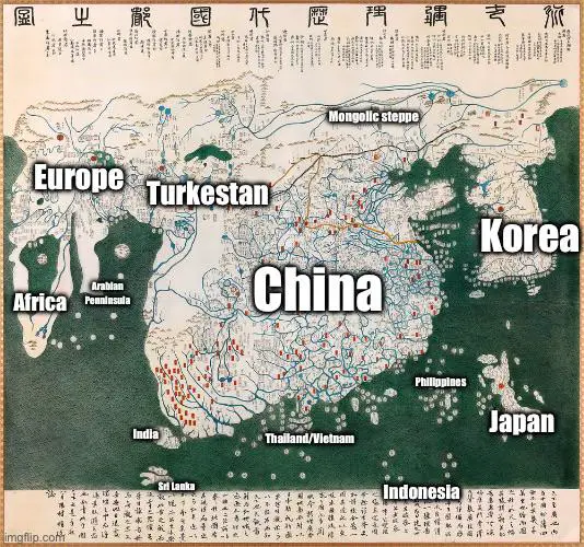
The Kangnido, or “Map of Historical Emperors and Kings and of Integrated Borders and Terrain,” wasn’t just a map. It was a revolutionary document that captured the imagination of a rising Korean kingdom and revealed an astonishing understanding of global geography decades before European explorers would chart similar territories.
A Collaborative Cartographic Achievement
Created in 1402 by scholars Ch’üan Chin and Li Hui, the Kangnido was more than a geographical representation. It was a bold statement of Korea’s intellectual prowess and global awareness during the newly established Joseon dynasty.
The map’s origins are as fascinating as its content. Korean officials obtained two earlier Chinese maps during a diplomatic mission in 1399. Recognizing their limitations, they transformed these sources into something groundbreaking.
What Made the Kangnido Extraordinary?
Unlike contemporary European maps, the Kangnido offered a remarkably nuanced view of the world:
- Africa was depicted with surprising accuracy, including approximately 35 place names
- Europe appeared with about 100 location markers, despite significant geographical distortions
- Islamic cartographic influences were evident throughout the map
Global Knowledge, Far Ahead of Its Time
Most stunning was the map’s representation of regions far beyond Korea’s immediate surroundings. At a time when most mapmakers focused on their local territories, the Kangnido demonstrated a sophisticated understanding of distant lands.
The map integrated geographical knowledge from multiple sources: Chinese, Korean, and Islamic traditions. This collaborative approach resulted in a document that was both a political statement and an intellectual achievement.
A Map’s Journey
Interestingly, while created in Korea, the original Kangnido didn’t survive in its homeland. Four copies exist in Japan, with the most pristine version housed at Ryūkoku University in Kyoto.
The map likely arrived in Japan during Toyotomi Hideyoshi’s invasions of Korea in the late 16th century—a testament to the complex historical interactions of East Asian nations.
More Than Just Geography
The Kangnido represented more than lines on paper. It symbolized Korea’s ambition, intellectual curiosity, and desire to understand the broader world. By placing China and Korea prominently at the map’s center, it also revealed the cultural and political perspectives of its creators.
This map predates European world maps and challenges our understanding of medieval geographical knowledge. It stands as a powerful reminder that advanced scientific and cartographic thinking wasn’t exclusive to Western traditions.
The Kangnido isn’t just a historical artifact—it’s a window into a sophisticated world of intellectual exchange and curiosity that existed centuries before our modern globalized era.
What do you think about this remarkable piece of cartographic history? Have you ever seen or heard about maps that challenged your understanding of medieval knowledge? Share your thoughts below!


