Leonardo da Vinci (1452 – 1519) was a Renaissance man who is generally acknowledged as one of the most diversely talented individuals ever to have existed. While his name originally rested on his successes as an artist, he also became known for his sketches and notes on science and invention, including anatomy, botany, paleontology, astronomy.
In addition to his well-known creative engineering and scientific talents, Leonardo da Vinci has excellent fame as a land surveyor and cartographer, drawing maps for a broad spectrum of hydroengineering projects for the governors of Vatican, Milan, Florence, and Arezzo, amongst others.
The maps below demonstrate Leonardo Da Vinci’s prodigious talent for geography and cartography.
In 1502 Leonardo Da Vinci was charged with assisting Cesare Borgia, son of Pope Alexander VI, become more knowledgeable of the town’s layout. To do it, he made an innovative map that mixed cutting-edge surveying methods with his artistic vision. The resulting “ichnographic” satellite style map of Imola (Italy) map was a step ahead for cartography, modifying it from a somewhat creative artistic practice to an informational asset. In the contemporary age of GPS and satellite and aerial photography, producing an unbiased ichnographic plan isn’t too tricky. But this Leonardo Da Vinci’s map pre-dated satellites and airplanes by centuries.
Leonardo presumably used an instrument called a Bussola, a tool that measures degrees inside a circle. Scrupulous recording each corner and crossing angles in the town and measuring their length from each other would have provided him the information he required to recreate the city as observed from above, using the Bussola to keep precise scale.
The map of the Pontine marshes, Italy (1514)
The Pontine marshes map is an Italian Renaissance pen, ink, and chalk drawing created by Leonardo da Vinci in 1515. The map covers approximately 40 miles (65 km) of the shoreline south of Rome, north to the upper left, and represented the plain Pontine marshes.
A thoughtfully completed map of the southern part of Tuscany, centering on the sizeable swampy lake that once occupied the Valdichiana. North is to the left, the Tiber river flows on the top border of the map, and the southern end of the Arno river is at the center left. The city of Arezzo is at the upper left, The capital city of the region of Umbria – Perugia at the upper right, and the city of Siena in the lower center.
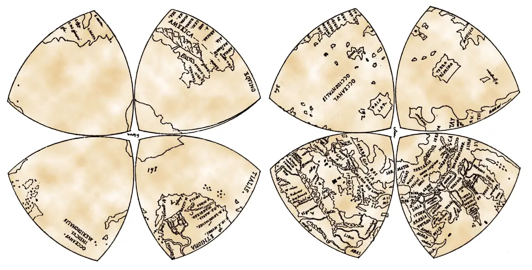
Leonardo da Vinci’s world map was found among his documents in the Royal Library (Windsor), one of the first to name the Americas and has the continents’ proper overall configuration.
At that period, a wide variety of projective practices tried to represent the globe’s curved surface onto a sheet of paper’s planar surface. Leonardo da Vinci presents his unique solution to this unsolvable dilemma that had been frustrating mapmakers since the Greek geometer Ptolemy and before. By dividing the planet’s surface into eight octant petals into two florets, he produces a unique projection that had by far the most isometric mapping geometry to that time (although at the cost of cuts that divided some of the landmasses).
This Leonardo da Vinci’s projection may be compared with a recent mapping to the same geographic projection. He has exaggerated the size of the European continent. Nonetheless, he shows India, China, Japan, Malaysia, and even the Russian Far East peninsula is almost the proper proportions. Exceptionally, he has nearly the exact dimensions for both poles of our planet, including Antarctica’s landmass, something reached by no other mapmaker of the era or for the following two centuries! The Arctic is exceptionally extraordinary because it is continuously coated in a thick layer of ice.
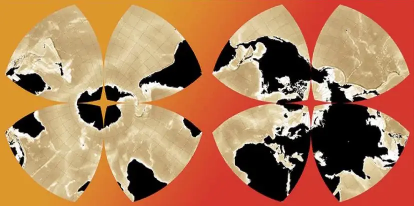
The map below shows modern projection of the globe onto Leonardo da Vinci’s octant projection.
You can learn more about Leonardo da Vinci from the following books: