The story of Mexico’s first imperial moment is a fascinating tale of ambition, complexity, and rapid transformation. In the early 19th century, a young nation emerged from the shadows of Spanish colonial rule, briefly blazing across the map of North America with unprecedented territorial scope.
The Path to Independence
Mexico’s journey to nationhood was anything but straightforward. After three centuries of Spanish colonial domination, the independence movement, led by figures like Miguel Hidalgo y Costilla and José María Morelos, challenged the existing order. The struggle began in 1810 and culminated in 1821 with the Plan of Iguala, which established the framework for Mexican independence.
The Birth of an Empire
Agustín de Iturbide, a former Spanish military commander who switched sides during the independence movement, became the driving force behind Mexico’s imperial ambitions. In 1822, he was proclaimed Emperor Agustín I, establishing the First Mexican Empire—a short-lived but remarkable political experiment.
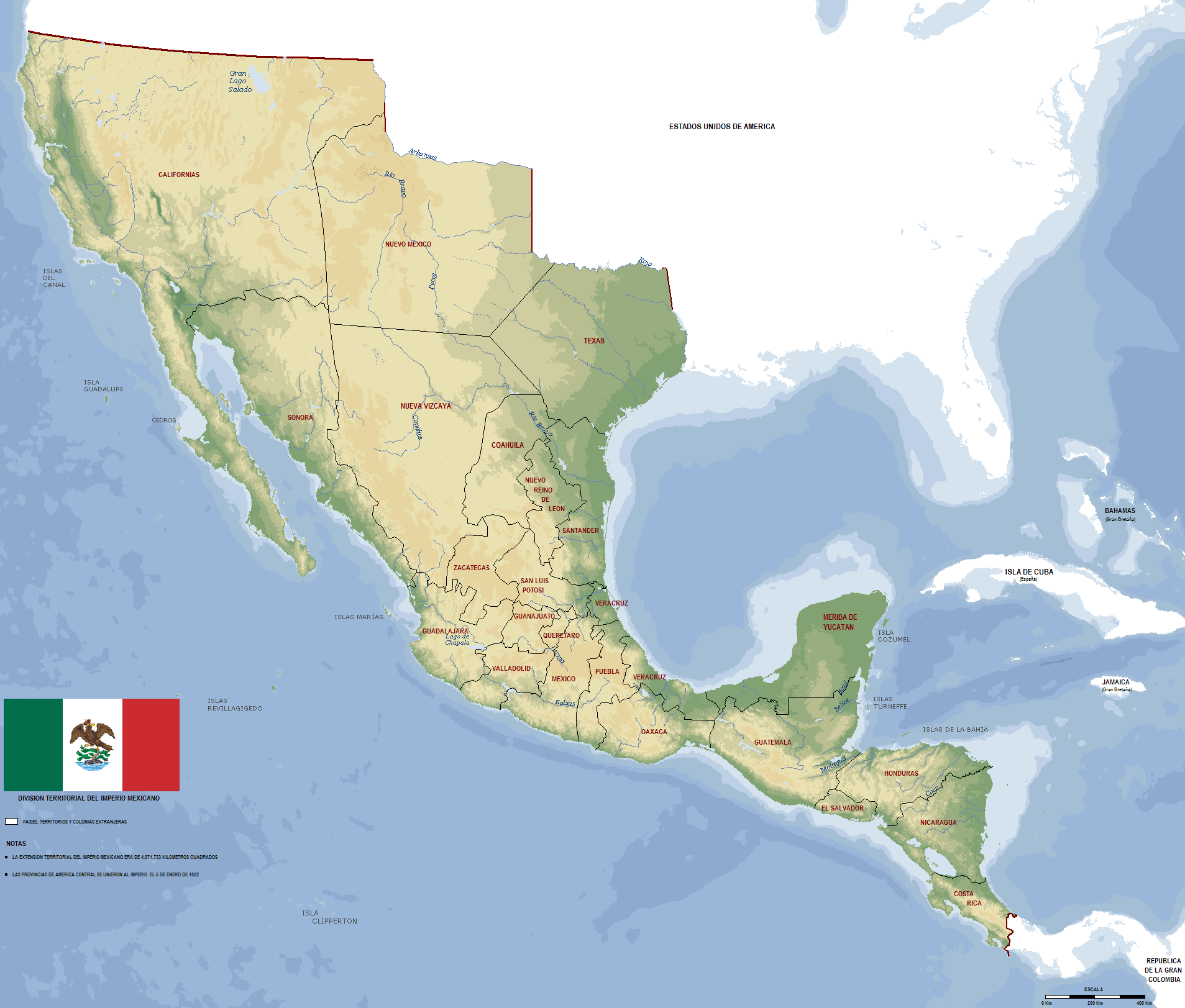
Territorial Extent and Composition
At its peak from 1821-1823, the First Mexican Empire was breathtaking in its geographical reach. The empire covered approximately:
1.7 million square miles (4.4 million square kilometers)
Stretched from modern-day Oregon in the north to Costa Rica in the south
The population during this period was estimated at around 6.2 million people, with a complex ethnic composition:
Small percentages of African descendants and other immigrant groups
Geographically, the population was concentrated in central and southern regions, with sparse settlements in northern territories.
Territories Under Imperial Control
The First Mexican Empire included:
Present-day Mexico
Guatemala
El Salvador
Honduras
Nicaragua
Costa Rica
Parts of what are now the southwestern United States (including California, Texas, New Mexico, and parts of Arizona)
Rapid Decline and Territorial Losses
The empire’s existence was remarkably brief. Internal political instability, regional conflicts, and external pressures quickly eroded its territorial integrity:
1823: Agustín de Iturbide is forced to abdicate
1824: Federal Republic established
1830s-1840s: Gradual loss of northern territories to the United States
Have you ever wondered about these “what if” moments in history? What are your thoughts on Mexico’s imperial experiment? Share your reflections in the comments below!


")

