How Cartoonists Used the Octopus to Show Russian Power: Comparing Maps 140 Years Apart
When it comes to political satire in cartography, some images stand the test of time. In 1877, British cartoonist Fred W. Rose created a map of Europe that portrayed Russia as a massive octopus stretching its tentacles across the continent. Nearly 140 years later, this powerful metaphor was revived to comment on modern European politics.
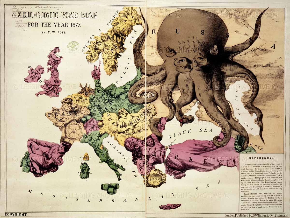
Rose’s “Serio-Comic War Map” of 1877 was published during a time of significant tensions between the Russian Empire and European powers. The map depicts Russia as a menacing octopus, its tentacles reaching toward various European nations. According to the Barron Maps Blog, this imagery was particularly potent during the Russo-Turkish War (1877-1878), when European nations grew increasingly concerned about Russian expansion.
The octopus metaphor wasn’t merely artistic flourish. It represented very real fears about Russian influence and territorial ambitions. Each tentacle on Rose’s map tells a story, showing how the Russian Empire was perceived to be grasping at different parts of Europe, from Constantinople to Poland.

Fast forward to 2018, and we see history rhyming in cartographic form. The modern interpretation maintains the octopus metaphor, this time with Vladimir Putin’s Russia at its center. The similarities between these maps, created 140 years apart, are remarkable and point to enduring themes in European geopolitics.
The 2018 version, titled “John Bull and His Friends,” pays homage to Rose’s original style while addressing contemporary political dynamics. The map reflects modern concerns about Russian influence, from energy politics to digital interference, showing how some geopolitical anxieties have evolved while others remain surprisingly constant.
These maps are part of a rich tradition of satirical cartography. The British Library notes that such maps became particularly popular during the 19th century, using humor and exaggeration to comment on international relations.
For those interested in decorative maps of Europe, here are some notable options available on Amazon:
- Vintage Europe Political Map Poster
- Modern Europe Wall Map, Laminated
- Historical Map of Europe Canvas Print
The persistence of the octopus metaphor in these maps shows how powerful visual symbols can be in expressing political concerns. Whether created in 1877 or 2018, these maps demonstrate that cartography can be both art and commentary, offering unique insights into how Europeans perceived threats to their security across different eras.
")


