Have you ever wondered how people mapped the world before airplanes and satellites? Surprisingly, accurate world maps came about earlier than many think, though the journey to create them was long and fascinating.
Let’s take a whirlwind tour through the history of world maps, showcasing how our understanding of Earth’s geography evolved over nearly two millennia.
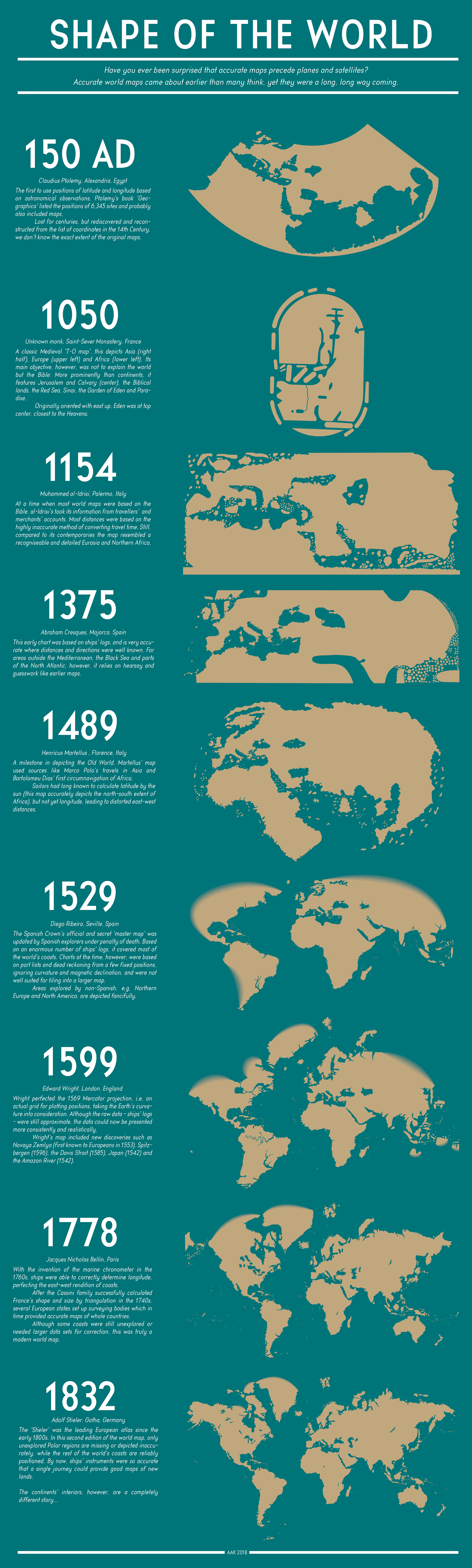
Claudius Ptolemy, an astronomer in Alexandria, Egypt, revolutionized mapmaking by introducing latitude and longitude. His book ‘Geographica’ listed coordinates for over 6,000 locations, possibly accompanied by maps. Though lost for centuries, his work was rediscovered in the 14th century, sparking a cartographic renaissance.
1050: The Medieval Worldview
Fast forward to medieval France, where an unknown monk at Saint-Sever Monastery created a map that was more theological than geographical. This “T-O map” depicted the world as a flat disc, with Jerusalem at its center. It’s a fascinating glimpse into how religion shaped people’s understanding of the world.
1154: Al-Idrisi’s Merchant Map
In 12th-century Sicily, Muhammad al-Idrisi crafted a map based on travelers’ and merchants’ accounts. While still inaccurate by modern standards, it offered a more realistic view of Eurasia and Northern Africa than its contemporaries.
1375: Cresques’ Nautical Chart
Abraham Cresques of Majorca created an early nautical chart that was remarkably accurate for well-traveled sea routes. However, it relied on hearsay for lesser-known areas, resulting in a mix of precision and fantasy.
1489: Martellus’ Old World Milestone
Henricus Martellus in Florence produced a groundbreaking map of the Old World, incorporating information from Marco Polo’s travels and recent African explorations. It accurately depicted north-south distances but struggled with east-west measurements due to the challenge of calculating longitude.
1529: Spain’s Secret Master Map
Diego Ribeiro‘s map, the Spanish Crown’s closely guarded secret, compiled data from countless explorer logs. While impressive in its coastal detail, it struggled to reconcile individual charts into a cohesive whole.
1599: Wright’s Mathematical Breakthrough
Edward Wright perfected the Mercator projection, creating a consistent grid that accounted for Earth’s curvature. This allowed for more accurate placement of new discoveries, from the Arctic to Japan.
1778: Bellin’s Longitude Revolution
With the invention of the marine chronometer, Jacques Nicholas Bellin‘s map finally solved the longitude problem. Combined with land surveys, this led to the first truly modern world maps.
1832: Stieler’s Near-Perfect Picture
Adolf Stieler‘s atlas represented the pinnacle of pre-modern cartography. Only the unexplored polar regions remained mysterious, while the rest of the world’s coastlines were mapped with remarkable accuracy.
As we look at these maps, we’re not just seeing lines on paper. We’re witnessing the gradual unveiling of our planet, driven by human curiosity, technological innovation, and the courage of explorers who ventured into the unknown. From religious symbolism to mathematical precision, each map tells a story of how we’ve come to understand our place in the world.
What’s your favorite historical map? And how do you think our mapping techniques might evolve in the future? Share your thoughts in the comments below!
Are you looking for old maps as home decor? Check out these maps available on Amazon:


")


