Germany isn’t just one country—it’s many countries living inside the same borders. Or at least, that’s how it often feels. Ask a Berliner and a Bavarian what makes Germany tick, and you might get answers so different they sound like they’re from separate continents. Political ideologies, dialects, culinary preferences, and even grocery store chains all offer reasons to split the country like a layer cake.
So, what are the funniest, weirdest, and most insightful ways to divide Germany?
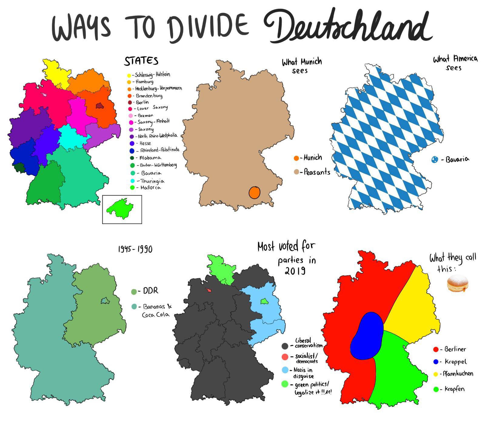
The Six Faces of Germany
Let’s start with one of the most shared sets of satirical maps created by Reddit user tagamotchi floating around the German-speaking internet. It’s titled “Six Ways to Divide Germany” and, though playful, it reveals real social, historical, and cultural divides.
Reddit user: tagamotchi
Here are a few of the divisions from that map set:
States (Bundesländer): The official divisions most of us know, but not always how people self-identify.
What Americans See: For many outsiders, Germany = Bavaria—lederhosen, beer halls, and Oktoberfest.
Cold War Legacy: From 1945 to 1990, Germany was literally divided into East (DDR) and West. The cultural differences remain, with some joking that the real border today is between banana-eaters and Coca-Cola drinkers.
Political Preferences (2019): You don’t have to dig deep into election maps to see how differently people vote across Germany. Bavaria tends to lean right, Berlin often swings left, and Saxony? It’s where you’ll spot some of the strongest support for far-right parties.
Pastry Confusion: Call it a Berliner in one city, a Pfannkuchen in another, or maybe even a Kreppel. Same sweet treat—four different names.
More Divisions, More Stereotypes
Another version of this satirical map series goes even further, adding humor and cultural commentary in equal measure.
Highlights from this version include:
ALDI Nord vs. ALDI Süd: The supermarket split that’s as much about branding as geography.
Language Wars: From “absurd gobbledygook” to “passive-aggressive dialect,” Germans don’t just speak differently—they mock each other’s speaking styles.
Political and Social Labels: You’ll find “hardcore conservatives,” “libtards,” “precariat,” and even “Nazis” marked out across regions. Clearly satirical, but pointing to real political tensions.
Conversation Styles: Some areas “never shut up,” others “don’t talk at all.” Small talk etiquette? It’s a regional art.
Oh, and Bielefeld? Whether it exists or not is a national inside joke. Some regions live for the meme.
The Bavaria Paradox: A Country Within a Country?
Then there’s Bavaria—Germany’s Texas. The region is so distinct, it deserves its own set of satirical maps.
Reddit user: invasiveorgan
From football loyalties to dialect zones and Catholic vs. Protestant enclaves, Bavaria can be divided again and again—each slice telling a different story about identity, pride, and cultural peculiarities. It’s one of the few places where people regularly say “I’m Bavarian” before they say “I’m German.”
At first glance, these maps are good for a laugh. But look a little closer, and you’ll spot something more meaningful. They highlight how Germany’s plaid of regions, shaped by history and politics, still influences daily life. And like all clever satire, they use humor to reveal the truth—about Germany, and maybe even about your own country too.
Want to dive even deeper into this cartographic comedy of culture and stereotypes? A fantastic book that compiles similar maps from across Europe (and beyond) is the “Atlas of Prejudice” by Yanko Tsvetkov. (Note: This link leads to Amazon.) It’s a smart, hilarious look at how people view the world—and how those views say more about us than the places we mock.


4 Ways to Divide Germany