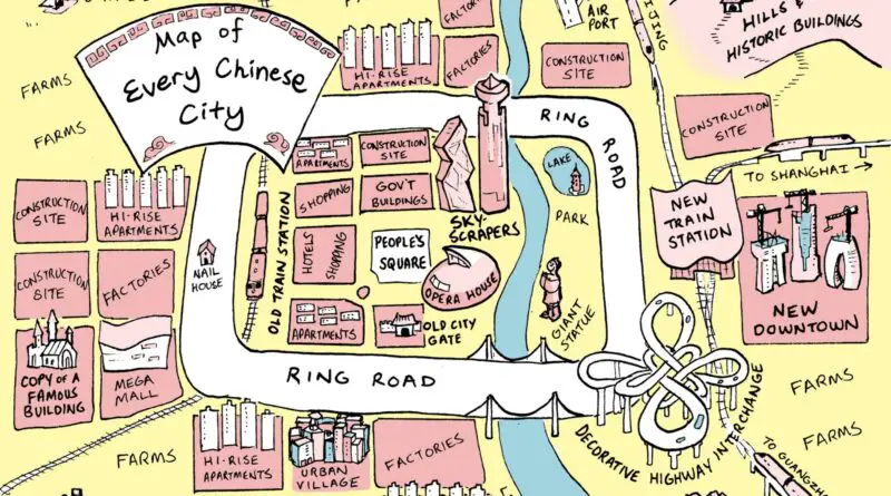
Skip to content
Vivid Maps Logo

Vivid Maps

Maps that explain the World


  • Atlases
  • Map Posters
  • Scratch Maps
  • Globes

Mapping Stereotypes

Map of Arab World
Languages Mapping Stereotypes 

Tearing Arab World apart

July 29, 2020January 17, 2021 Alex 0 Comments Arab World

The Arab World consists of the 22 Arab nations: Algeria, Bahrain, the Comoros Islands, Djibouti, Egypt, Iraq, Jordan, Kuwait, Lebanon, Libya, Morocco, Mauritania, Oman, Palestine, Qatar, Saudi Arabia, Somalia, Sudan, Syria, Tunisia, United Arab Emirates, and Yemen). It combines a population of around 423 mln people. The preponderance religion is Islam.

Read more
Tearing Baltic states apart
Mapping Stereotypes 

Tearing the Baltic states apart

July 10, 2020July 10, 2020 Alex 0 Comments Baltic countriea, Estonia, Latvia, Lithuania

Before World War I, the Baltic countries were part of the Russian Empire. The first independence was declared after the WWI. After the WWI Baltic nations became sovereign republics until their automatic inclusion in 1940 into the USSR, they obtained their autonomy from the USSR in 1991.

Read more
Google Trends Maps
Mapping Stereotypes 

Google Trends Maps

March 26, 2019March 26, 2019 Alex 0 Comments United States

“The least informative Google trends maps I’ve created over the years (all are real but not all cover the same

Read more
Mapping sterotypes: Ireland during WWII
Mapping Stereotypes Old maps Wars 

The Second World War map of Ireland to deter invaders

March 16, 2019March 16, 2019 Alex 0 Comments Ireland

On September 12, 1939, Ireland declared neutrality. Ireland told Britain not to send over any ships, submarines, or aircraft and informed Germany of Irish neutrality.

Read more
Eight ways to divide France
Mapping Stereotypes 

Tearing France apart

April 4, 2018December 13, 2020 Alex 0 Comments Maps of France

France is a nation, mainly located in Western Europe, and has several overseas territories bordering 11 countries. France is high a developed nation with the global’s 7th-largest economy by GDP and the 10th-largest by PPP. In terms of aggregate household wealth, France ranks 4th in the world.

Read more
9 Ways to Divide Russia
Mapping Stereotypes 

Tearing Russia apart

April 2, 2018January 1, 2021 Alex 0 Comments Russia

Russia is the biggest nation globally, the 9th-most populated country, and the most populous nation in Europe. Russia is one

Read more
The World According to Rome
Mapping Stereotypes 

The World According to Rome

March 2, 2018 Alex 0 Comments Roman Empire

The World according to Rome around the year 125 AD. Source: thetaleofrome.com   The world according to Roman Empire Source: Yanko

Read more
Nine Ways to Divide Turkey
Mapping Stereotypes 

Tearing Turkey Apart

February 21, 2018December 9, 2020 Alex 0 Comments Turkey

Turkey is a diverse nation and ethnically mixed due to its location at the intersections of Europe, the Middle East, Central Asia, its legacy, and its multi-ethnic and multiple religious Ottoman Empire.

Read more
Culinary Mapping Stereotypes 

Culinary maps of Europe according to France and Italy

February 19, 2018 Alex 0 Comments Europe, Italy, Maps of France

Culinary of Europe according to France   Culinary of Europe according to Italy   Source: Atlas of Prejudice

Read more
Tearing Brazil apart
Mapping Stereotypes 

Tearing Brazil apart

February 12, 2018November 17, 2018 Alex 0 Comments Brazil

Six ways to divide Brazil Reddit user: eukubernetes   Twelve ways to divide Brazil Reddit user: SoldadoTrifaldon   Related posts:

Read more
Page 1 of 10912345...102030...»Last »

Advertisement

Find Us On Facebook

Vivid Maps

Trending now

  • Historical Maps
  • Map of Modern and Historical range of the elephants
    Animals
  • Nine Ways to Divide Turkey
    Mapping Stereotypes
  • Maps 2020
    News, Vivid maps
  • Mapping

Advertisement


Globe drinks cabinets · Board games · Monopoly · Map-based strategy board games

Vivid Maps Tools

– Find cities with a similar climate
– Find cities with a similar climate (2050)
– How hot cities could be in 2050
– The U.S. Population Lines
– Convert Latitude/Longitude

– About

Copyright © 2021 Vivid Maps. All rights reserved.