The Amazon stays humid all year. Siberia freezes for months. The Sahara bakes under endless sun. Iceland gets drizzled on by cool Atlantic winds. Our planet packs incredible climate variety.
In 1884, Russian-German botanist Wladimir Köppen set out to map this variety in a systematic way. He worked with climatologist Rudolf Geiger to create a classification linking temperature and precipitation patterns to the vegetation that actually grows in each place.
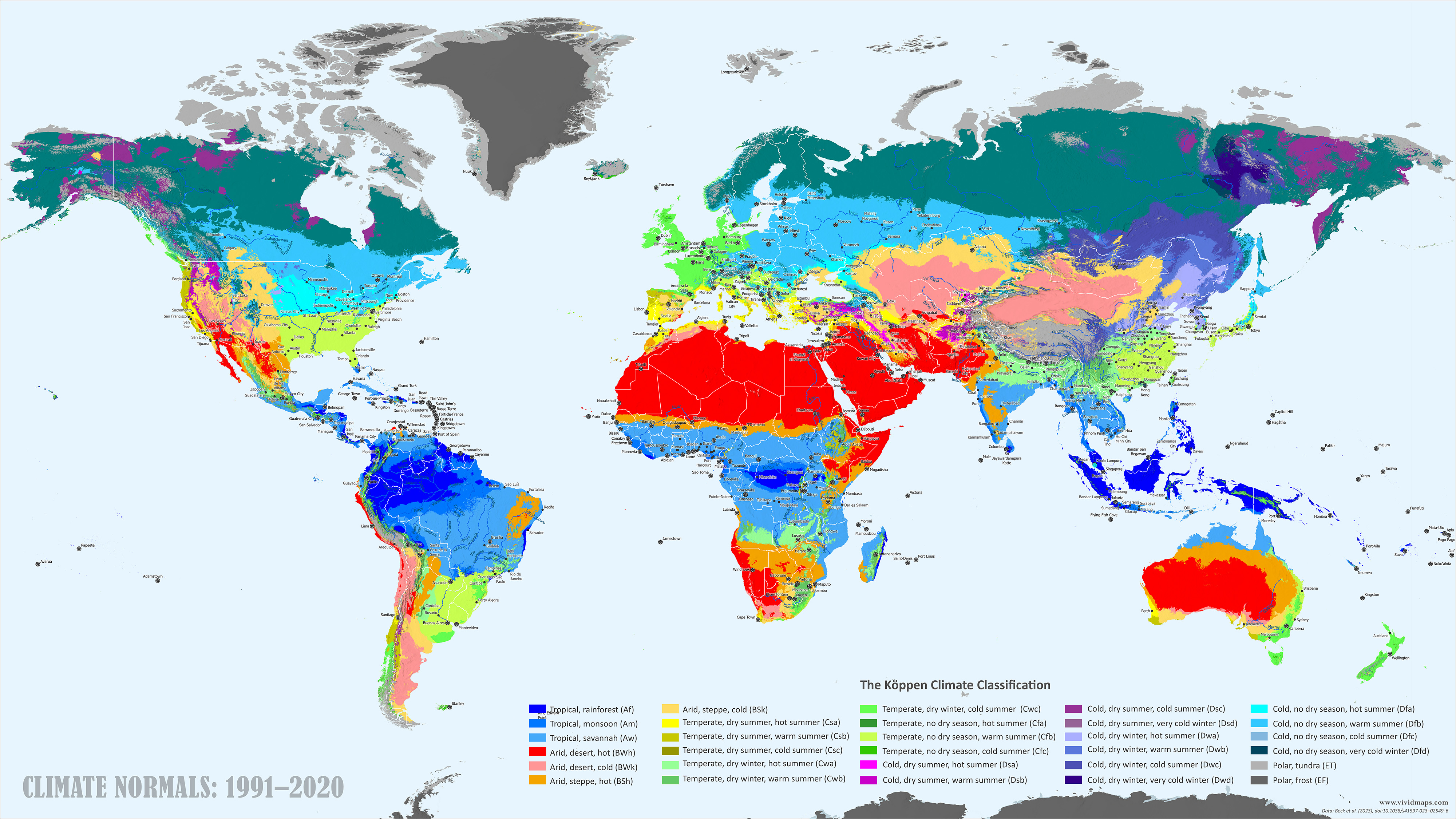
World Map of Köppen-Geiger Climate Classification
Each climate gets a letter code. The first letter indicates the main group: A for tropical, B for dry, C for temperate, D for cold/continental, E for polar. Additional letters specify precipitation timing and temperature extremes.
Code
Short name
Description
Af
Tropical — rainforest
Warm and rainy year-round, with no dry season
Am
Tropical — monsoon
Warm with intense summer rains and a brief dry period
Aw
Tropical — savannah
Warm with a distinct dry season and a wet season.
BWh
Arid — desert (hot)
Very dry, hot deserts.
BWk
Arid — desert (cold)
Very dry deserts with cool or cold winters.
BSh
Arid — steppe (hot)
Semi-arid, generally hot.
BSk
Arid — steppe (cold)
Semi-arid with colder winters.
Csa
Temperate — dry summer, hot
Mediterranean: dry, hot summers; mild, wetter winters.
Csb
Temperate — dry summer, warm
Mediterranean with milder summers.
Csc
Temperate — dry summer, cool
Cold summer Mediterranean climate. Seasonal rainfall is concentrated in warm months; dry winters.
Cwa
Temperate — dry winter, hot
Monsoon-influenced humid subtropical climate (seasonal rainfall is concentrated in warm months; dry winters).
Cwb
Temperate — dry winter, warm
Subtropical highland climate – upland variant of Cwa with milder summers.
Cwc
Temperate — dry winter, cool
Cold subtropical highland climate (high-elevation cooler variant of Cwb).
Cfa
Temperate — no dry season, hot
Humid subtropical climate — rainfall year-round, hot summers.
Continental with dry summers and hot peaks (rare).
Dsb
Cold — dry summer, warm
Continental with dry summers and warm summers.
Dsc
Cold — dry summer, cool
Cold continental with dry summers.
Dsd
Cold — dry summer, very cold
Very cold continental extremes.
Dwa
Cold — dry winter, hot
Monsoon-influenced continental with hot summers.
Dwb
Cold — dry winter, warm
Monsoon-influenced continental with warm summers.
Dwc
Cold — dry winter, cold
Subarctic with dry winters.
Dwd
Cold — dry winter, very cold
Extreme subarctic cold.
Dfa
Cold — no dry season, hot
Humid continental, hot summers.
Dfb
Cold — no dry season, warm
Humid continental, warm summers.
Dfc
Cold — no dry season, cool
Subarctic climates with short cool summers.
Dfd
Cold — no dry season, very cold
Extremely cold subarctic climate
ET
Polar — tundra
Warmest month 0–10 °C; tundra vegetation.
EF
Polar — frost
No month ≥ 0 °C — permanent frost.
The map above shows the current climates on our planet according to the Köppen and Geiger classification. Tropical rainforest (Af, deep blue) circles the equator: the Amazon, Congo Basin, Indonesia. Step away from the equator and you hit seasonal tropics. Savannahs (Aw) cover Africa’s Sahel, northern Australia, and chunks of South America where the year splits into wet and dry seasons. The big deserts glow red and pink: Sahara, Arabian Peninsula, Australia’s interior, Atacama. Yellow steppe zones (BSh, BSk) surround these deserts in places where rain is scarce but not totally absent.
Mediterranean climate appears in five scattered locations: California, central Chile, the Mediterranean Basin itself, South Africa’s Cape, southwestern Australia. All five get dry summers and wet winters. Humid subtropical zones (Cfa, lime green) spread across southeastern China, the southeastern US, southeastern Australia, and parts of South America. Summer heat plus reliable rain defines these regions. Northern Europe, New Zealand, and the Pacific Northwest have oceanic climate (Cfb) with mild temperatures and rain year-round.
Continental interiors of North America and Eurasia run through all the D classifications, from Dfa (hot-summer continental) to Dfc and Dfd (subarctic). Northeastern Siberia and interior Alaska, some of Earth’s coldest inhabited spots, appear in dark teal. Polar zones circle the Arctic Ocean as tundra (ET) and cover Greenland and Antarctica as ice caps (EF).
Climate Zones Are Moving
These zones are dynamic. To illustrate this, I used high-resolution Köppen-Geiger data from Beck et al. (2023) to generate 1-kilometer resolution maps covering 1901 to 2099.
Changes over the past century are already visible. Arctic tundra has shrunk across Alaska, Canada, Scandinavia, and Siberia. Temperate zones have crept poleward. Northern China used to freeze hard in winter; now parts receive enough summer rain to qualify as humid subtropical. Several Mediterranean coasts have dried out enough to reclassify as semi-arid steppe. Mountain boundaries have climbed higher in the Andes, Himalayas, Rockies, and Alps. Arid zones have expanded around the Mediterranean Basin, across Africa’s Sahel, through central Asia, and in southwestern North America.
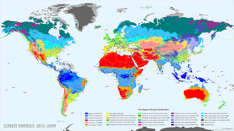
Future Projections
For the future, I used the SSP2-4.5 scenario. It is considered the most likely scenario; under it, emissions keep rising through mid-century, then plateau as renewable energy adoption accelerates and climate policies begin to take effect.
By the late 21st century, the changes accelerate. Arctic tundra gets squeezed back to the far northern coasts and a few islands. The subarctic retreats with it. Current boreal forest regions would experience milder winters and longer growing seasons. Tropical rainforests hold their cores, but edges shift. Rainforest-savannah boundaries move as dry seasons lengthen and intensify, converting rainforest into seasonal forest or savannah.
Dry regions expand. Mediterranean coasts dry out enough in places to switch into steppe classification. Southern Africa sees similar changes. Central Asian deserts push outward. Australia’s already huge arid interior gets even bigger. The mid-latitudes warm considerably. Southern Europe by century’s end resembles today’s North Africa. Northern Europe takes on central Europe’s current climate.
From the early 1900s to the late 2000s, climate zones migrate hundreds of kilometers poleward. The boreal forest belt moves north; its southern edge becomes temperate forest. In Kazakhstan, Mongolia, and surrounding areas, steppes push into valleys and foothills that used to receive more moisture. Rainforest edges experience more drought pressure. Mountain climates keep moving upslope in the Andes, Himalayas, Alps, and Rockies.
I also made maps for 1931–1960 and 2041–2070 to capture the mid-century transition. Here’s the full animation:
Data and Methods: All maps use the 1 km Köppen-Geiger dataset from Beck, H.E., et al. (2023), “High-resolution (1 km) Köppen-Geiger maps for 1901–2099 based on constrained CMIP6 projections,” Scientific Data 10, 724. Available at: https://www.nature.com/articles/s41597-023-02549-6.


?")

