Have you ever wondered why some places in the United States feel like they exist in completely different worlds when it comes to weather? A fascinating map by Reddit user AJgloe, using NOAA data, reveals just how dramatic these temperature differences can be across the country.
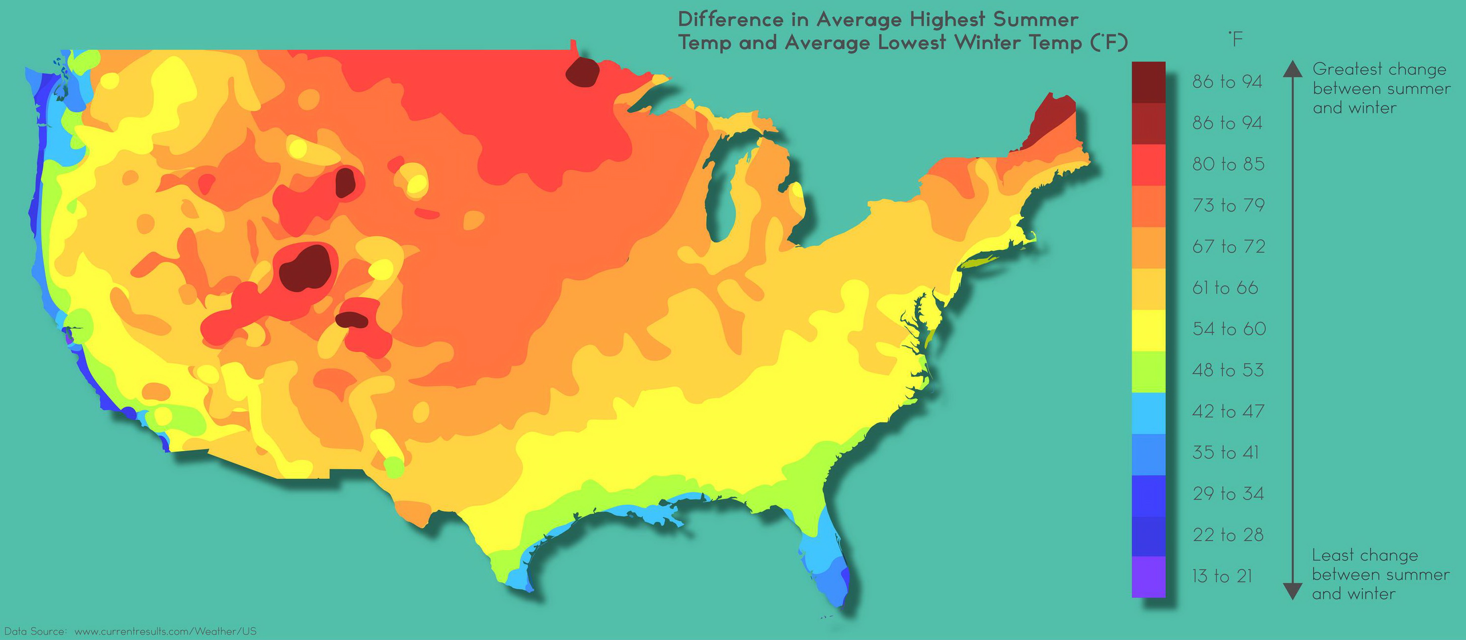
The map of the United States above shows the variation between average summer highs and winter lows, and the results are striking. Colorado stands out with one of the most extreme swings: summer highs around 86°F (30°C) plunging to winter lows of approximately 17°F (-8°C)—a staggering 69°F (38°C) difference that would challenge anyone’s wardrobe planning.
There’s a clear pattern emerging from this data: drier regions consistently show the most dramatic temperature variations. This happens because moisture in the air acts as a natural temperature regulator. Humid coastal areas maintain more stable temperatures year-round, while arid inland regions lack this moderating influence, leading to those extreme seasonal shifts.
Where Temperature Extremes Rule (And Where They Don’t)
Looking at this map, certain regions jump out for their massive temperature swings. The Rocky Mountain states dominate the extreme end of the spectrum. Colorado, Wyoming, and Montana show some of the largest differences—often exceeding 80-90°F (44-50°C) between their hottest summer days and coldest winter nights. These inland, high-elevation areas lack the moderating influence of large water bodies, creating these dramatic seasonal contrasts.
North Dakota and South Dakota also experience brutal temperature ranges, with differences reaching 85-90°F (47-50°C). The continental climate here means scorching summers can hit 100°F+ (37.8°C+) while winter lows plunge well below 0°F (-17.8°C).
On the opposite end, coastal regions show the smallest temperature differences. Southern Florida experiences remarkably stable temperatures year-round, with differences of only 20-30°F (11-17°C) between summer highs and winter lows. The Gulf Stream’s warm waters keep temperatures moderate throughout the year.
California’s coast also shows minimal variation—places like San Francisco and San Diego maintain differences of just 25-35°F (14-19°C) thanks to the Pacific Ocean’s thermal mass. Hawaii represents the ultimate in temperature stability, with seasonal variations often limited to just 15-20°F (8-11°C).
The hottest absolute temperatures still belong to Death Valley, California, which holds the world recordhttps://vividmaps.com/detailed-climate-map-of-united-states/ at 134°F (56.7°C) from 1913, and regularly averages 108.5°F (42.5°C). Phoenix, Arizona, with summer averages of 93.7°F (34.3°C) and recent stretches of 31 consecutive days above 110°F (43.3°C), demonstrates how urban areas intensify already extreme heat.
Climate Projections: What the Data Shows
According to the Fourth National Climate Assessment, temperature extremes are projected to intensify significantly across different US regions by 2050-2100:
Southwest Region: Average temperatures are expected to rise by 2.5°F to 5.5°F (1.4°C to 3.1°C) by 2041-2070 and by 5.5°F to 9.5°F (3.1°C to 5.3°C) by 2070-2099, with the number of days above 100°F (37.8°C) potentially doubling in cities like Phoenix and Las Vegas.
Great Plains: The region faces a projected increase by 3.5°F to 9.5°F (1.9°C to 5.3°C) by 2085, with more frequent heat waves lasting 4-6 days longer than current patterns.
Southeast: Expected temperature increases of 3-5°F (1.7°C to 2.8°C) by 2050, with dangerous heat index values (above 105°F/40.6°C) projected to occur four months a year.
Northeast: Despite being cooler overall, this region may see average temperatures rise another 2.5 to 4°F (1.4°C to 2.2°C) in winter and 1.5°F to 3.5°F (0.8°C to 1.9°C) in summer above historic levels over the next several decades, with cities like New York potentially experiencing 30–46 days per year with the heat index reaching 95°F (35°C) or above by 2050.
The IPCC Sixth Assessment Report specifically notes that heat extremes are likely to reach critical tolerance thresholds for human health and agriculture much sooner in already hot regions, with compound heat-humidity events becoming particularly dangerous in the Gulf Coast states.
These dramatic temperature patterns we see today are just the beginning. The map showing current temperature extremes will look quite different in 30-50 years as these projections become reality. Regions that already experience wild temperature swings may see even more extreme variations, while areas currently enjoying moderate climates could join the ranks of temperature roller coasters.
What changes have you already noticed in your area’s weather patterns?
?")


