The first French colonial empire peaked in 1680 at over 10 million square kilometers (3.9 million square miles), ranking second in the world at the time behind Spain’s empire
The second French colonial empire peaked in 1936 at 13.5 million square kilometers (5.2 million square miles), about 10 percent of the world’s land, second only to Britain’s empire
World War II broke the second empire apart within a few years, as Britain, the United States, Germany, and Japan each occupied a different piece of French territory
Metropolitan France today covers 551,695 square kilometers (213,011 square miles), and its five overseas departments add roughly 89,168 square kilometers (34,428 square miles) more
France’s overseas territories give it an exclusive economic zone of roughly 10.2 million square kilometers (3.9 million square miles) of ocean, making it almost the same size as that of the United States.
Metropolitan France shares land borders with eight countries, from Spain and Andorra in the south to Belgium and Germany in the north. Add French Guiana, an overseas department wedged between Brazil and Suriname on South America’s northeast coast, and the border count reaches ten. Most of that reach traces back to two colonial empires built over roughly four centuries, the first centered on North America and the Caribbean, the second on Africa and Southeast Asia.
The First French Colonial Empire
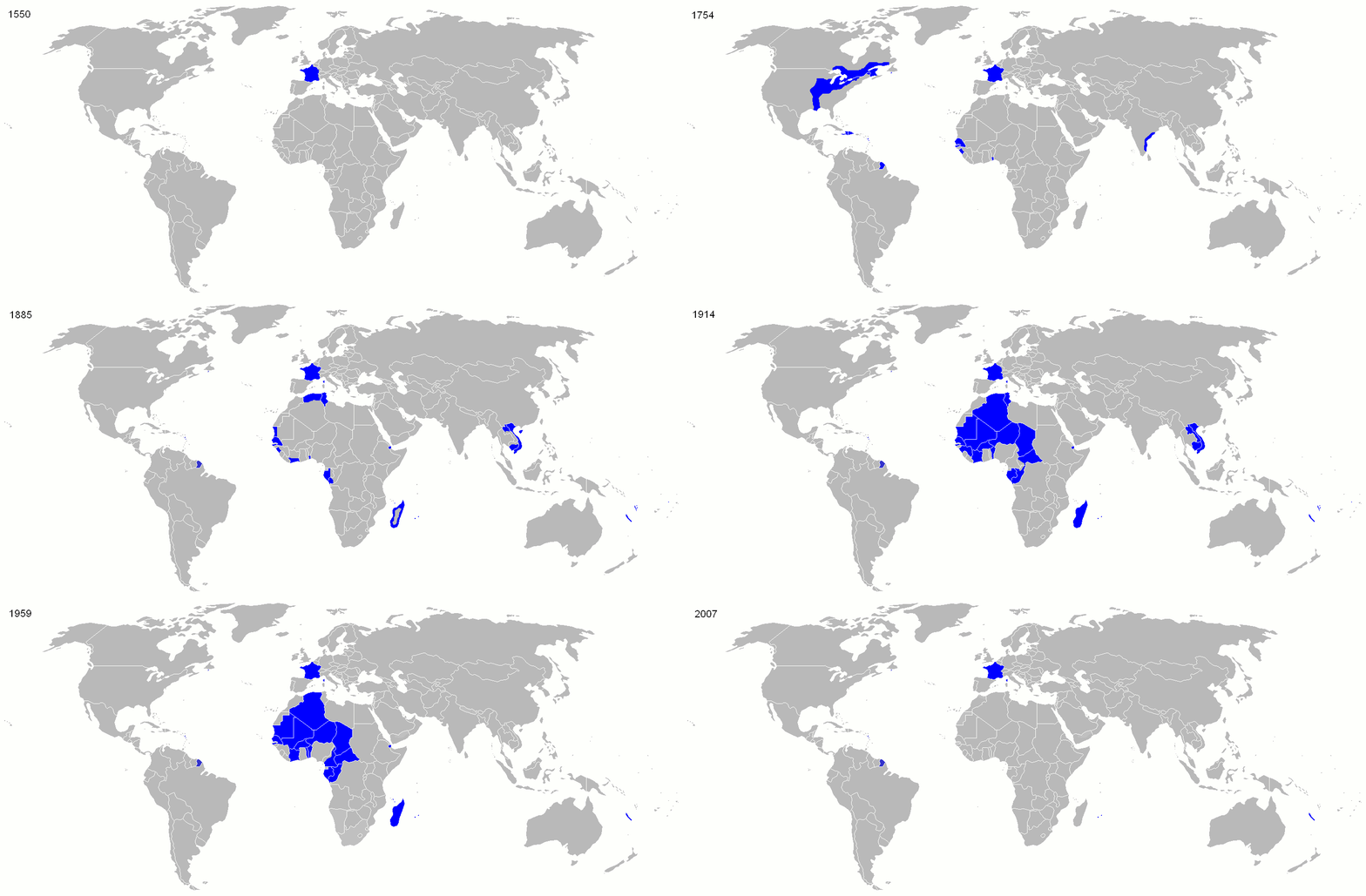
The first French colonial empire took shape across the sixteenth and seventeenth centuries, built on New France in North America, sugar islands in the Caribbean, and trading posts along India’s coast. It reached its largest extent in 1680, just over 10 million square kilometers (3.9 million square miles), ranking second in the world at the time behind only the Spanish Empire. The Seven Years’ War ended that expansion. France ceded Canada to Britain and Louisiana west of the Mississippi to Spain under the 1763 Treaty of Paris. Napoleon sold the remaining Louisiana Territory to the United States in 1803, and by 1814 what was left of the first empire amounted to a scatter of Caribbean islands and Indian trading posts.
Napoleon was building something else entirely back in Europe during those same years. At its height in 1811, he ruled 130 departments straight from Paris, nearly 900,000 square kilometers (347,000 square miles) reaching into the modern Netherlands, Germany, and Italy, plus the Illyrian Provinces on the Adriatic, covering parts of today’s Slovenia and Croatia.
The Second French Colonial Empire
A second empire rose in the decades after 1830. France invaded Algeria that year, then expanded fast through the Scramble for Africa and into Indochina and the South Pacific. It peaked in 1936 at over 13.5 million square kilometers (5.2 million square miles), about 10 percent of the world’s dry land, ranking second again, this time behind the British Empire. Add the historical peak of the first empire and the combined total reaches 24 million square kilometers (9.3 million square miles), more than any other colonial empire in history except Britain’s.
Era
Area
First French colonial empire, peak 1680
10,000,000+ km² (3,900,000+ sq mi)
Second French colonial empire, peak 1936
13,500,000 km² (5,200,000 sq mi)
Both colonial empires combined, historical peaks added
24,000,000 km² (9,300,000 sq mi)
Napoleon’s First French Empire, peak 1811
~900,000 km² (347,000 sq mi)
Metropolitan France, today
551,695 km² (213,011 sq mi)
Overseas departments and regions, today
89,168 km² (34,428 sq mi)
Full overseas France, today
120,396 km² (46,485 sq mi)
France’s exclusive economic zone, today
10,186,624 km² (3,933,078 sq mi)
How World War II Broke the Empire Apart
World War II took the second empire apart within a few years, and different pieces fell to different powers. British and Free French troops seized Syria and Lebanon from Vichy France in 1941. American and British forces landed in Morocco and Algeria in November 1942 during Operation Torch, and Germany rushed troops into Tunisia in response, holding the territory until May 1943. Japan’s occupation of Indochina came in two stages, a 1940 agreement that let Japanese troops use Vichy-controlled bases, then a full takeover in March 1945.
Where French Control Reached
The world map below pulls every kind of French presence into one picture, colonies, protectorates, mandates, military occupations, and short-lived exploratory claims.
Reddit user: carolusmegamagnus
France Today
What is left of both empires is far smaller. Metropolitan France covers 551,695 square kilometers (213,011 square miles). Five overseas departments and regions add roughly 89,168 square kilometers (34,428 square miles) more. French Guiana alone accounts for most of that, 83,534 square kilometers (32,253 square miles) on South America’s northeast coast, with Guadeloupe, Martinique, Réunion, and Mayotte filling out the rest. Beyond those five, France also holds New Caledonia and French Polynesia under a different legal status, along with a handful of smaller island territories scattered across the Pacific, the Atlantic, and the Indian Ocean. Counting all of it, the full overseas total comes to about 120,396 square kilometers (46,485 square miles).
France’s Major Overseas Territories
Territory
Region
Area
Distance from Paris
French Guiana
South America
83,534 km² (32,253 sq mi)
7,080 km (4,400 mi)
New Caledonia
South Pacific
18,575 km² (7,172 sq mi)
16,740 km (10,400 mi)
French Polynesia
South Pacific
3,521 km² (1,360 sq mi)
15,715 km (9,765 mi)
Réunion
Indian Ocean
2,512 km² (970 sq mi)
9,380 km (5,830 mi)
Guadeloupe
Caribbean
1,628 km² (629 sq mi)
6,760 km (4,200 mi)
Martinique
Caribbean
1,128 km² (436 sq mi)
6,875 km (4,270 mi)
Distance separates these places from Paris more than area does. New Caledonia is roughly 16,740 kilometers (10,400 miles) from Paris by air, further than any of France’s other major territories. French Polynesia is close behind at 15,715 kilometers (9,765 miles). Réunion, out in the Indian Ocean, comes in at 9,380 kilometers (5,830 miles), a route Air France still classifies as a domestic flight. French Guiana is the closest of the major pieces at 7,080 kilometers (4,400 miles), almost exactly the same distance as Paris to Mumbai.