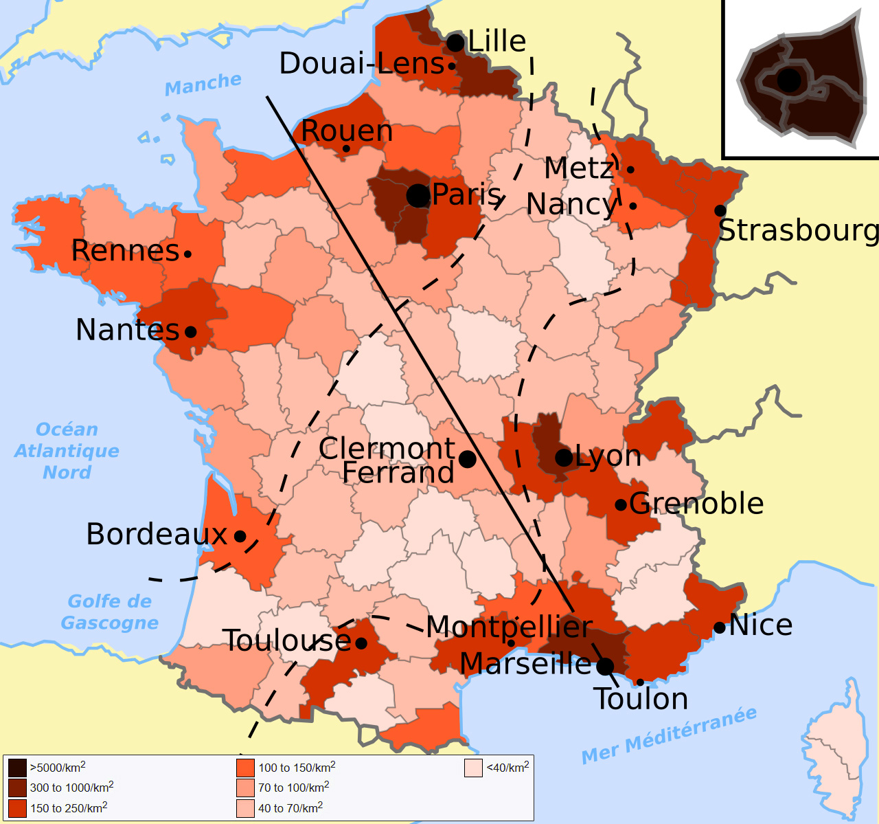
Metropolitan France covers about 544,000 square kilometers (210,000 square miles) and has a population of 66.8 million, an average of roughly 123 per square kilometer (318 per square mile). That average hides almost everything interesting. Île-de-France, the region built around Paris, packs in more than 1,000 people per square kilometer (2,687 per square mile). Corsica, out in the Mediterranean, has just 41 (106 per square mile). Between those two numbers is most of what a population density map of France actually has to explain.
Key takeaways
Metropolitan France holds 66.8 million people across roughly 544,000 km² (210,000 sq mi), an average of about 123 people per km² (318 per sq mi)
Density varies enormously by region, from 41 people per km² (106/sq mi) in Corsica to over 1,000 (2,687/sq mi) in Île-de-France, a 25-fold difference
Paris’s centuries-long role as France’s political and economic center explains much of the imbalance
A low-density corridor known as the diagonale du vide, the empty diagonal, stretches from the northeast to the southwest, a legacy of the 19th and 20th century rural exodus
Nouvelle-Aquitaine is the largest region by area (84,061 km², 32,456 sq mi) but ranks just 10th out of 13 in density
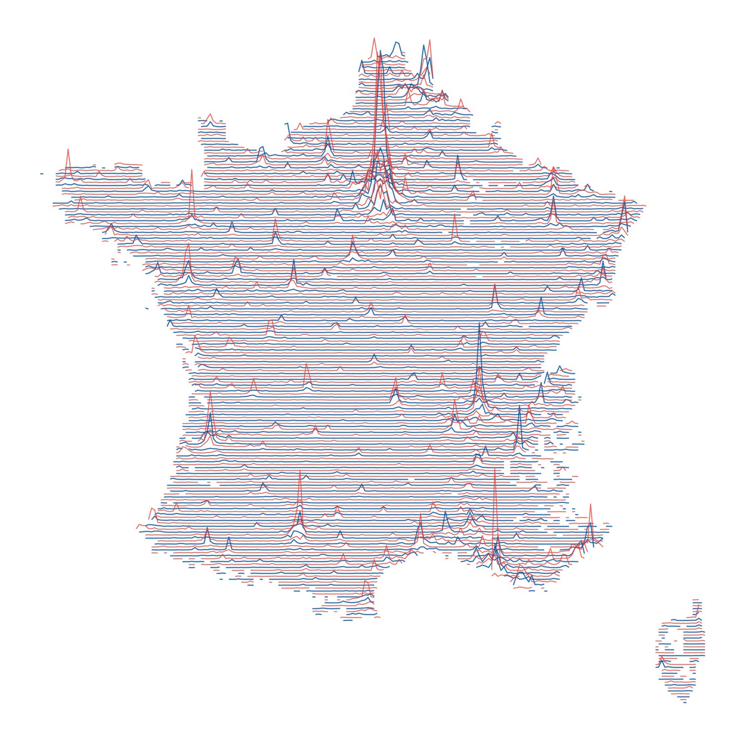
The same imbalance shows up at a larger scale too. Paris, London, the Milan area and the industrial cluster around Düsseldorf, Essen and Dortmund in western Germany all appear as their own islands of density on a finer grid map covering France and its neighbors.
Megaсities on the map: Paris; London; the Milan metro area; the west German megacity (Dusseldorf, Essen, Dortmund). Reddit user AJgloe
Paris explains a lot of it. The city has been France’s political, economic and cultural center for centuries, and that pull never really eased off. Corporate headquarters, universities, ministries and media all cluster in Île-de-France long after the original reasons for clustering there stopped being strategic and simply became self-reinforcing.
Large parts of the interior emptied out for close to the opposite reason. During the rural exodus of the 19th and 20th centuries, farm work mechanized and industrial jobs pulled workers toward cities, and many small communes never recovered. Geographers call the resulting low-density corridor, stretching from the Ardennes near the Belgian border down through the Massif Central to the Landes near Spain, the diagonale du vide, the empty diagonal. Density inside that corridor drops below 30 people per square kilometer (78 per square mile) in places, roughly a quarter of the national average.
An animated view of that shift, decade by decade from the 19th century to today, makes the emptying-out easier to follow than any single static map.
The coasts picked up much of what the interior lost. Brittany, the Atlantic side of Nouvelle-Aquitaine and the Mediterranean edge of Provence-Alpes-Côte d’Azur have all gained residents for decades, pulled first by retirement migration and tourism jobs, more recently by remote work.
INSEE, populations de référence 2023 · en vigueur 1 janv. 2026
France by population density
Tap or click a region to see its numbers. Color follows density, dark for sparse, gold for dense.
●
Click any region on the map to see its population, area, and density in both metric and imperial units.
SELECTED REGION
Population
Area
Density
41/km² (106/sq mi)1,038/km² (2,687/sq mi)
Region
Population
Area
Density
Île-de-France
12,463,067
12,012 km² (4,638 sq mi)
1,037.6/km² (2,687.2/sq mi)
Auvergne-Rhône-Alpes
8,205,557
69,711 km² (26,916 sq mi)
117.7/km² (304.9/sq mi)
Nouvelle-Aquitaine
6,150,451
84,061 km² (32,456 sq mi)
73.2/km² (189.5/sq mi)
Occitanie
6,124,653
72,724 km² (28,079 sq mi)
84.2/km² (218.1/sq mi)
Hauts-de-France
5,992,194
31,713 km² (12,244 sq mi)
189.0/km² (489.4/sq mi)
Grand Est
5,563,378
57,433 km² (22,175 sq mi)
96.9/km² (250.9/sq mi)
Provence-Alpes-Côte d’Azur
5,218,960
31,400 km² (12,124 sq mi)
166.2/km² (430.5/sq mi)
Pays de la Loire
3,907,156
32,082 km² (12,387 sq mi)
121.8/km² (315.4/sq mi)
Bretagne
3,449,370
27,208 km² (10,505 sq mi)
126.8/km² (328.4/sq mi)
Normandie
3,345,842
29,906 km² (11,547 sq mi)
111.9/km² (289.8/sq mi)
Bourgogne-Franche-Comté
2,802,670
47,784 km² (18,450 sq mi)
58.7/km² (151.9/sq mi)
Centre-Val de Loire
2,587,031
39,151 km² (15,116 sq mi)
66.1/km² (171.1/sq mi)
Corse
355,486
8,680 km² (3,351 sq mi)
41.0/km² (106.1/sq mi)
Ranking these from memory is harder than it looks. Try it below.
QUIZ · INSEE population data
Rank France’s regions by population
Click regions directly on the map, most populated first. A numbered marker drops on each one as you go, and the list on the right fills in to match.
Auvergne-Rhône-Alpes usually catches people out for second place. Home to Lyon, Grenoble and the French Alps, it holds 8.2 million residents, ahead of every region except Île-de-France.