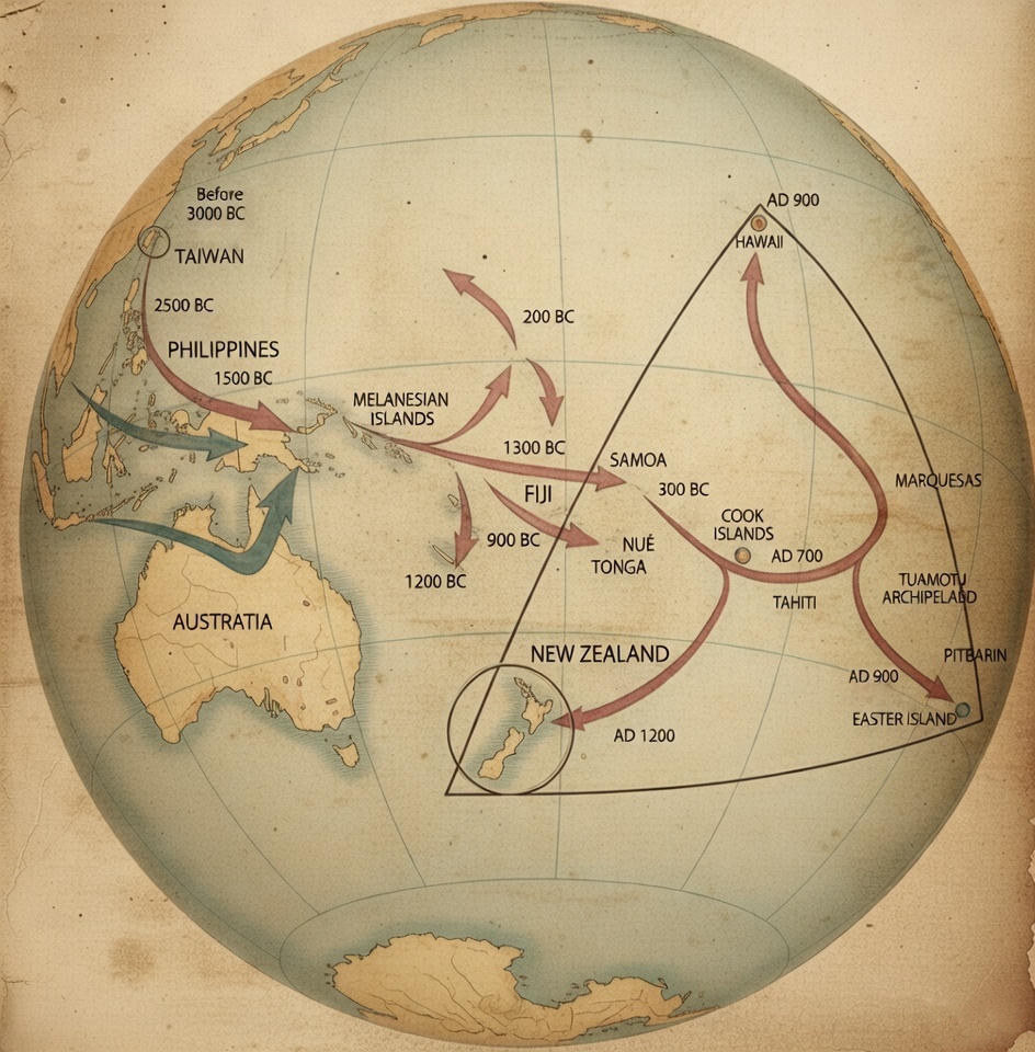
Taiwan to Hawaii. Taiwan to New Zealand. Look at a map. The distances are staggering for people in wooden canoes. This story starts before 3000 BC when people left Taiwan. Over the next four thousand years, their descendants island-hopped eastward and southward across the Pacific. New Zealand was the endpoint, reached around 1200 AD.
Migration Timeline:
Taiwan: before 3000 BC
Philippines: 2500 BC
New Britain (Papua New Guinea): 1500 BC
Samoa (from Melanesian Islands): 1300 BC
Cook Islands: 800 BC
Hawaii: AD 900
Easter Island: AD 900
New Zealand: AD 1200
Every voyage lasted weeks at sea. Get your navigation wrong by even a small amount and you miss the island completely. The ocean is vast, the islands are specks. When archaeologists excavate island settlements, they find pigs, chickens, taro, breadfruit. The same domesticated species on islands thousands of miles apart. Someone deliberately carried them in canoes.
Around 800 BC, the Cook Islands became a launching point. Voyagers sailed north to Hawaii. Others went east to Easter Island. Still others headed southwest to New Zealand. The trips to Hawaii and Easter Island both happened around 900 AD. New Zealand came about three hundred years later.
Star navigation made this possible. The horizon got divided into 32 segments. The full circle is 360 degrees, so each segment was about 11 degrees. Specific stars rose and set in each segment. Navigators learned these patterns by heart. Sail toward the rising point of your chosen star, night after night, and your canoe stays on course for weeks.
Two hulls lashed side by side made the canoes stable in heavy seas. The gap between them held supplies. Water containers, dried food, seed plants, pigs, chickens. Everything you’d need to start fresh on an island you’d never seen before.
Bird migrations helped with navigation. Certain species fly between islands on regular schedules. The long-tailed cuckoo makes an annual flight between Tahiti and New Zealand. Navigators watched for these migrations and sometimes followed the flocks.
Clouds block the stars regularly. When that happened, navigators used ocean swells instead. Swells move in consistent directions. Feel them passing under your canoe, and you can hold your heading without stars.
The timeline ends at 1200 AD. By then, Polynesians had found and settled habitable islands across about 8,000 miles of Pacific. No written charts existed. No compasses, no metal navigation instruments.
Pull up a Pacific map and look at those scattered islands. Today we need GPS to find them. Polynesians used stars, swells, and birds.