Where Do the French Live?
France is a relatively large country—about 551,695 square kilometers (213,011 square miles) in metropolitan area—but its population isn’t evenly spread out. Rural regions, especially the Massif Central and the southwestern interior, have seen steady population decline over the decades. In French geography, this has led to the idea of a so-called “diagonale du vide”—a broad band of low population stretching from the northeast to the southwest. You can see it not just in statistics, but on maps, in abandoned villages, and even in slower infrastructure development.
That brings us to this creative map by Reddit user Calvein, which takes population density data from INSEE (the French National Institute of Statistics and Economic Studies) and turns it into something visual—and almost musical.
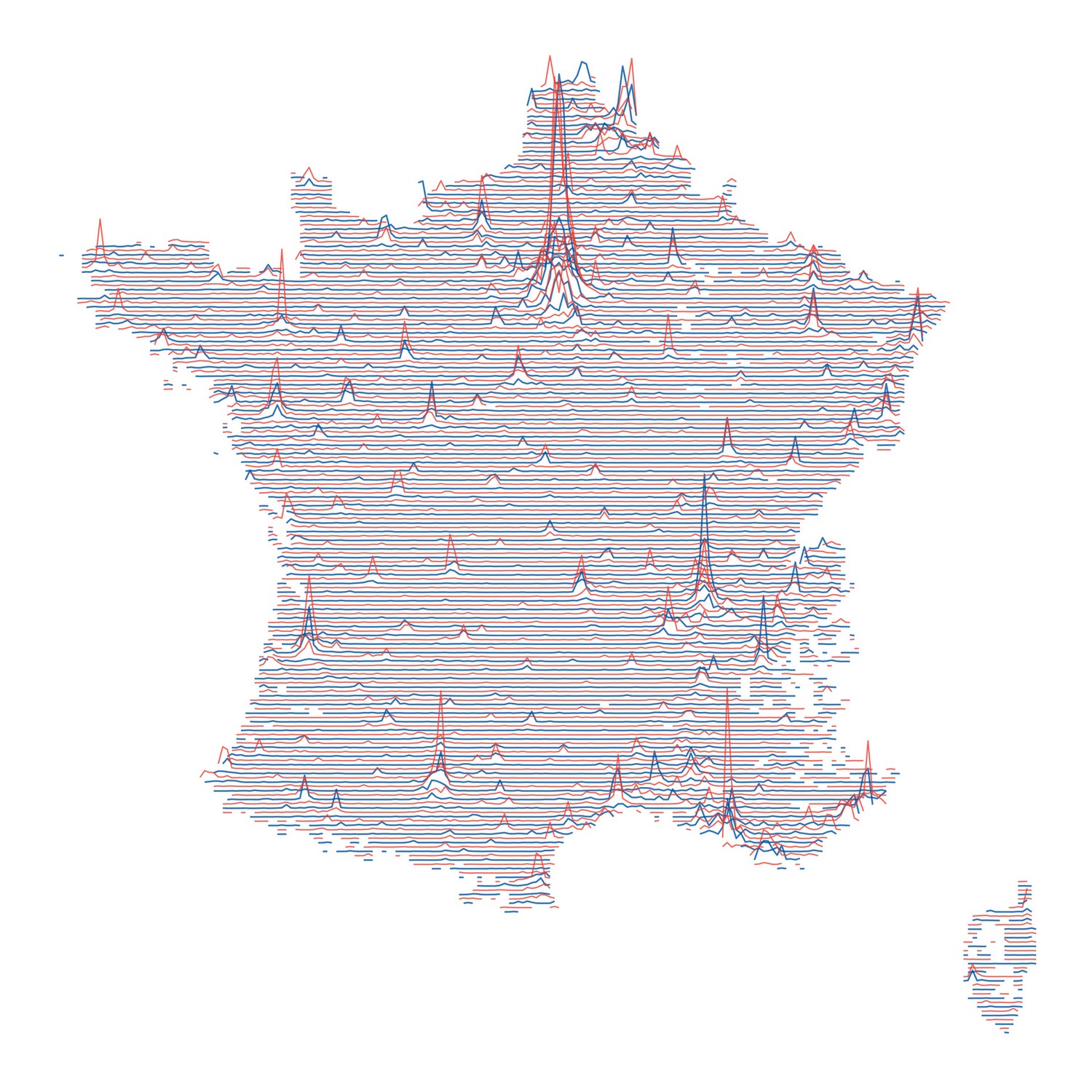
Instead of dots or shaded gradients, the map uses flowing lines that look like elevation contours. The style is inspired by Joy Division’s Unknown Pleasures album cover, and at a glance, it resembles a topographic model. But what you’re actually seeing isn’t landforms. It’s people. Each swell, ripple, and slope reflects where people live—and how many of them there are per square kilometer.
It’s an abstract design, but not abstract in its meaning. The Île-de-France region, home to Paris, immediately stands out. With over 12 million people in the metro area, nearly 1 in 5 French residents lives in or around the capital. Other major urban areas like Lyon, Marseille, Lille, and Toulouse also rise from the page in these wave-like ridges.
This kind of map works because France, like many countries, is highly urbanized. About 82% of the population lives in urban areas, according to the World Bank. But unlike a standard population map, this one feels more alive. There’s a rhythm to it. You’re not just reading where people are—you’re seeing it with a sense of scale and motion.
In contrast, vast stretches of the countryside appear flat and empty, especially across central France and along parts of the southwest. These aren’t just lightly populated—they’re part of a long-running demographic shift. As industries centralized, services moved to cities, and younger generations sought work elsewhere, rural areas hollowed out.
Even so, they still hold cultural weight in France—places of heritage, agriculture, and identity. But visually, this map captures a very modern reality: that most French people live in and around a handful of cities.
Maps like this are more than art or curiosity—they’re a visual way to make big demographic trends feel immediate and understandable. And in this case, they remind us that even something as abstract as a line can tell us exactly where people are.


