21 maps that explain Russia
What do you know about the largest country in the world? Below is a comprehensive atlas of various maps explaining Russia’s geography, history, politics, and economics that will break many stereotypes about this country.

Table of Contents
Global position and boundaries
Russia is the largest transcontinental country located in Eastern Europe and Asia. It covers over 1/8 of the Earth’s inhabited land area (17.1 million sq km or 6.6 million sq mi), extending 11 time zones, and bordering 16 sovereign countries.
A straight line connecting Russia’s Westernmost and Easternmost points passes through no Russian soil whatsoever!

Russia is the only one country separating Norway from North Korea! The map below shows the nearest country to different parts of Russia.

Russia has one of the longest international land borders. The Russian-Kazakh border stretches for more than 7.6 thousand kilometers (The U.S. and Canada have the longest border – 8.9 thousand km).
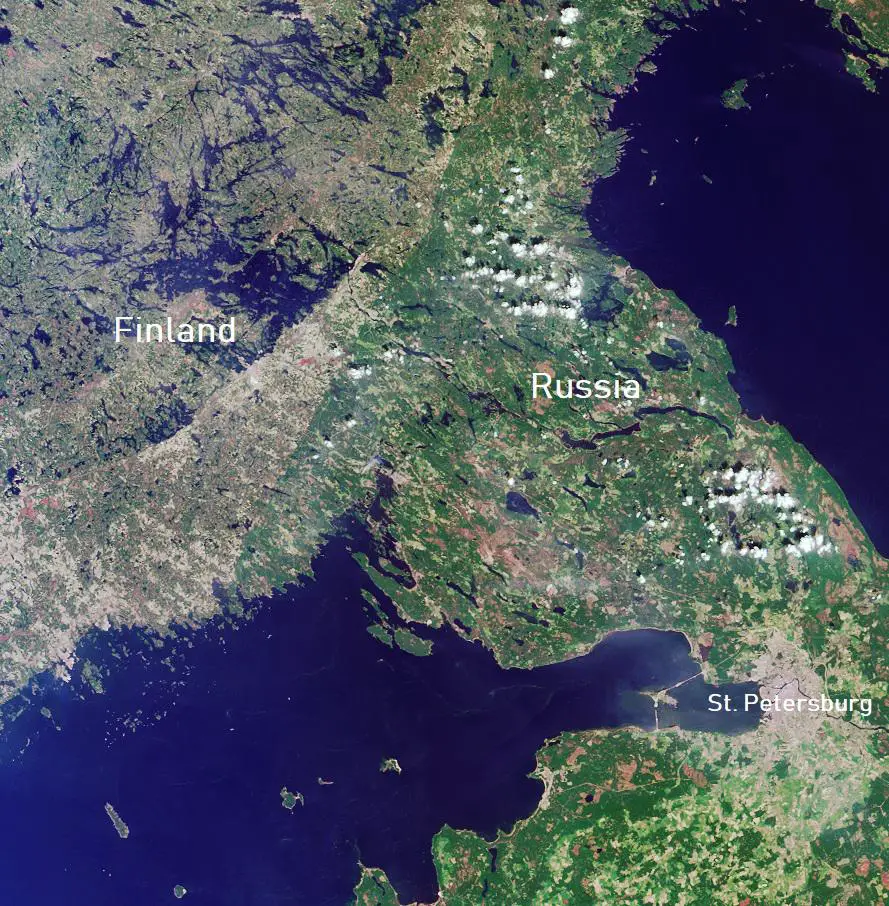
Due to the low population density and insignificant anthropogenic transformation of landscapes, Russia’s border with some countries can be seen even from space.

Climate
Most of Northern European Russia, Northern Siberia, and North of the Far East has a subarctic climate, with overly harsh winters.
The Northern Pole of Cold is located in the North Siberian Sakha Republic with a record low temperature of −71.2°C (−96.2°F).
Throughout much of Russia’s territory, there are four distinguished seasons: autumn, winter, spring, and summer. The coldest month is January (February on the coastland); the warmest month usually is July.
Few people know, but in Russia, there are territories with a subtropical climate. Subtropics are mainly located in the vicinity of Sochi, on the Black Sea coast of the Krasnodar Region.

You can compare the climate of most Russian cities with the climate of other cities in the world here.
Population geography
Although Russia is the 9th-most populous nation and the most populous country in Europe, the Russian Federation is one of the world’s most sparsely populated and urbanized. About 50% of the nation’s total area is forested, concentrating about 4/5 of its entire population of about 145 million on its smaller and dense western part than its larger and sparse eastern portion.
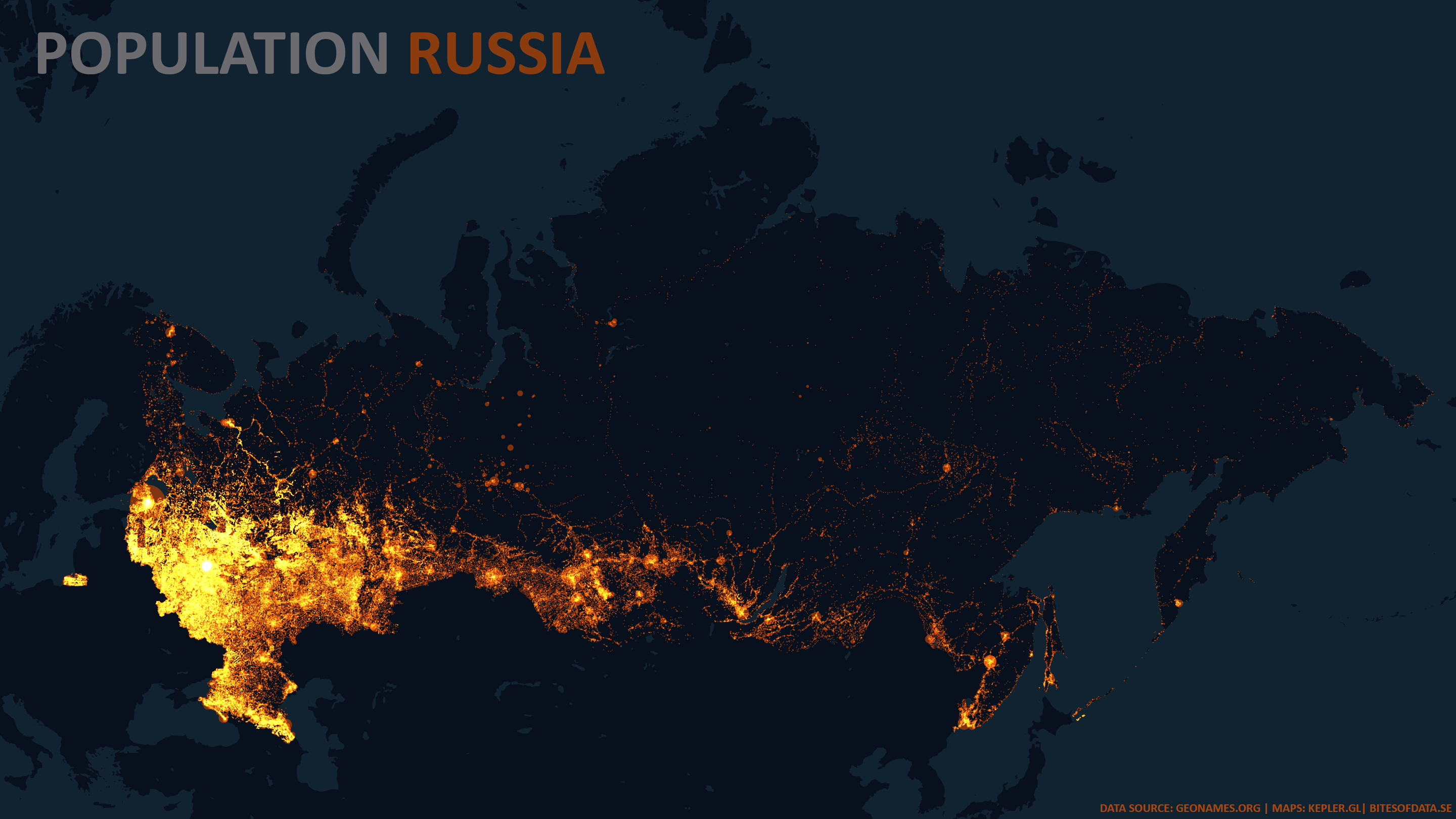
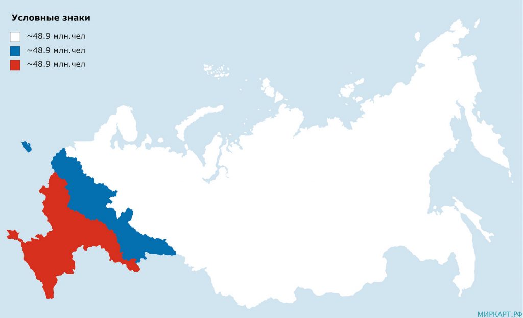
The map below shows Russia divided by population into 3 equal areas.
Russian forests and the Amazon rainforests are the planet’s lungs. About 66% of Russia’s territory is covered with forests, agricultural crops occupy 22% of the land. Almost 20% of Russian territory is deer pastures. That’s mainly the land of native Siberian deer hunters inside the Arctic circle.

Many Russians leave villages and small towns and move to big cities. Therefore, near cities, you can see many abandoned villages.
The three maps below illustrate the urban population, the average population of rural settlements, and the abandoned villages in Russia.


Moscow is the capital of Russia and the largest urban area in Europe, and among the largest in the world, with about 20 million inhabitants. Other major most populous cities include St. Petersburg (5.4 mln), Novosibirsk (1.6 mln), Yekaterinburg (1.5 mln), Kazan (1.3 mln), Nizhny Novgorod (1.3 mln), Chelyabinsk (1.2 mln), Samara (1.2 mln), Omsk (1.2 mln), and Rostov-on-Don (1.1 mln).
Moscow is the only capital in the world situated at a distance of over 1000 km from any mountain range (>700m). Tim Marshall’s book Prisoners of Geography: Ten Maps That Explain Everything About the World explains why the Russian state expanded intensively, trying to take over the entire plain and mountain ranges to ensure the state’s security.

The most ancient cities in Russia are Suzdal (1024), Vladimir (1108), Bryansk (985), Uglich (937), Pskov (903), Smolensk (863), Rostov Veliky (862), Belozersk (862), Murom (862), Veliky Novgorod (859), Derbent (438). It should be noted that the city of Derbent was previously part of the Persian Empire.
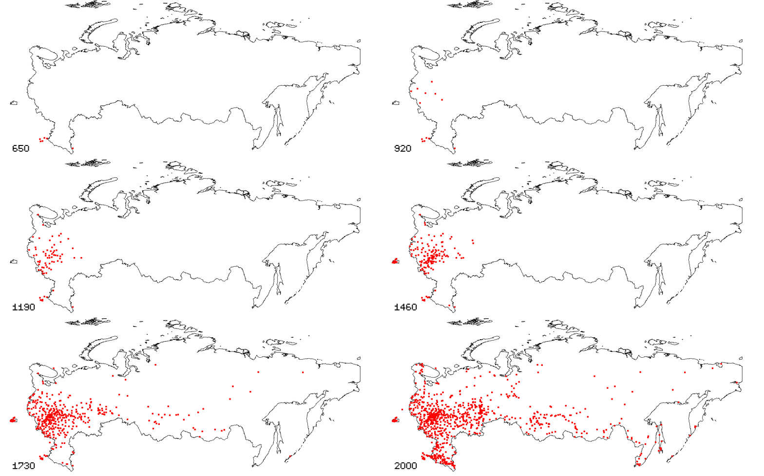
The animated map below shows the foundation of 875 Russian cities.
Russia ranks fifth by total road network size (1.5 mln km), behind the U.S. (6.9 mln km), India (5.9 mln km), China (5.0 mln km), and Brazil (1.8 mln km). But because of the enormous size of the country, the density of the road network even in the European part of Russia, is considerably inferior to the density of the road network in other countries. The map below shows roads on either side of the Finland-Russian border.

Ethnic groups
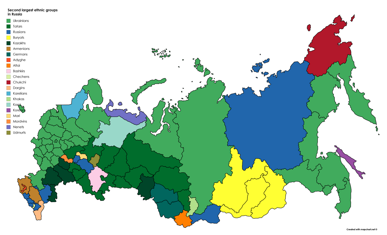
Russia is a multinational country with almost 200 ethnic groups named as nationalities. These ethnic groups’ populations differ enormously, from millions (Russians, Tatars, Ukrainians) to under 100 (e.g., Kereks, Krymchaks, Ruthenians).
The map below shows the percentage of ethnic Russians in Russia.

In most parts of Russia, Tatar and Ukrainians are the second-largest ethnic groups in Russia. Before the collapse of the USSR, Ukrainians were the second largest ethnic group.
Religion
Christianity was the religious self-identification of about 47% of the Russian population. Most of them are Orthodox Cristian. Orthodox Christian believers made up 42.6% of the total population of Russia.
Islam is the second-largest religion in Russia after Orthodox Christianity. Nowadays, about 15 million Muslims live in Russia, or 10.3% of the total population.

Economy
Russia’s economy is the 5h-largest national economy in Europe, the 11th-largest on the planet in terms of nominal GDP, and the 6th-largest by purchasing power parity.
Russia’s enormous geography is a crucial determinant of its economic activity, with some experts predicting that Russia holds over 30% of the world’s natural resources (oil, natural gas, precious metals, etc.). In 2012, gas and oil exports accounted for 16% of the country’s GDP.
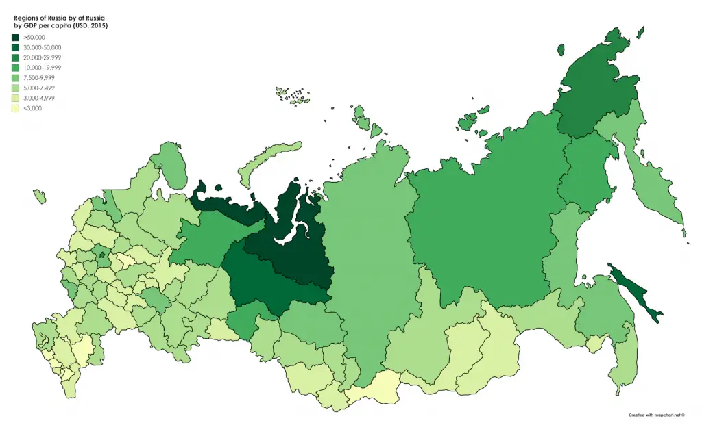
Russia’s economic development is uneven geographically, with the Moscow region providing a substantial GDP share.
The map below shows regions of Russia by GDP per capita.
Crime
Many people think Russia is dangerous, but this is not entirely true. In many American states, the murder rate is higher than in Russia. The map below shows U.S. states with higher (in red) and lower (in blue) murder rates than Russia.
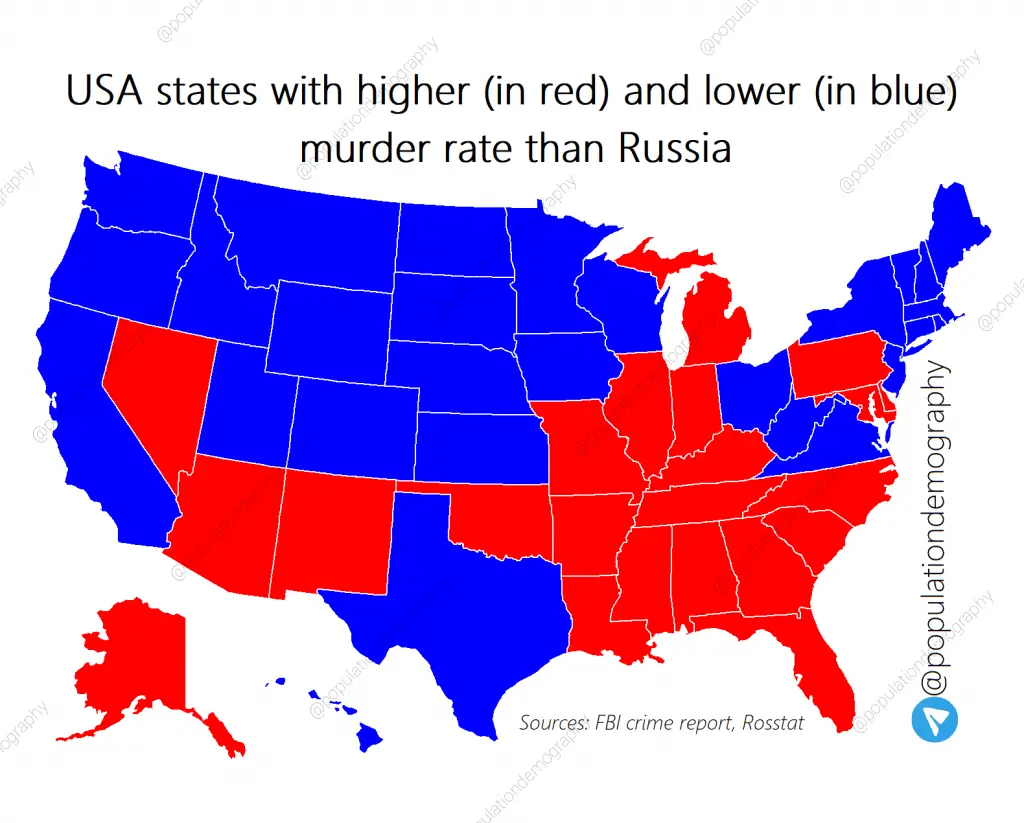
The murder rate in Russia is about 6 per 100 thousand people, which depicts a notable drop over the past 15 years (in 2001, the homicide rate was about 30). The map below shows regions of Russia by murder rate.

But Russia has the highest suicide rates in Europe (26.5 suicides per 100,000 people), followed by Lithuania (25.7 suicides per 1000,000 people), and exceeds the world average suicide rates by 2.5 times. If we consider only male suicides, then Russia will become the absolute world leader. The suicide rate among Russian men is 48.3 per 100 thousand of the population. Half of all suicides are related to alcohol consumption.




many of these maps are missing Crimea… very strange…
It is because Crimea is actually part of Ukraine 😉
yeah and india is a part of united kingdom sure kid
crimea is part of ukraine, also why are you supposing that he is a kid
Vatnik activities
It may have been part of ukraine before, but now it’s part of Russia, because there was a vote and the majority of people, like more than 90% of the residents voted to join Russia, because they are 90% ethnic Russians. Just like the eastern regions of ukraine are 90% ethnic Russians that ukraine has been tormenting for years and this is what caused the war – ukrainains were listening to the west and NATO to poke Russia and not be afraid because the west will back them up, and now everything is worse of everyone.
Crimea is occupied by Russia, but it is not acknowledged by other countries as part of Russia.
Moskovia is only historical Russians land with capital Moscow. Other lans are ocupayed by russians by russian empire.
Good YouTube videos came across & provide simplified nuance ☺️?
#1 (Part 1)
https://youtu.be/exJ024Zdzdk?si=quXgcMHcbaUksogE
#2 (Part 2)
https://youtu.be/fQ_ZRBLFOXw?si=QdCaz7U7G81rGUQF
#3 (Part 3)
https://youtu.be/FVmmASrAL-Q?si=-6aP_PTZYTSejmSB
#4 (Part 4)
https://youtu.be/7OFyn_KSy80?si=zYVEqrr622awFPZG
May take a few days to watch ?
Слава миру без Путина
?????????