16 Maps That Explain France
France has many layers—physical, historical, and cultural—and maps are one of the clearest ways to make sense of them. Whether it’s the deep past or lighthearted modern disagreements, cartography helps turn facts into something you can see and understand. Below are 15 maps that each highlight a different aspect of France, from its Ice Age coastlines to its overseas borders and regional language differences.
1. France 20,000 Years Ago – The Last Glacial Maximum
During the peak of the last Ice Age, much of northern Europe was covered in glaciers, and sea levels were far lower. The map below shows that what is now France looked very different—coastlines extended further west, and the English Channel didn’t even exist yet. Humans were already present, mostly as hunter-gatherers.

2. France’s Borders: From Europe to South America
France shares land borders with 11 countries, totaling about 4,176 kilometers (2,595 miles)—roughly the same distance as Paris to New York. But its longest land border isn’t with Spain, Italy, or Germany—it’s with Brazil, thanks to French Guiana in South America.

3. France’s Overseas Territories
Most people picture France in Europe, but the country stretches across five continents. From Réunion in the Indian Ocean to New Caledonia in the Pacific, France maintains several overseas territories with varying levels of autonomy. These regions are legally part of France, with representation in the national government.

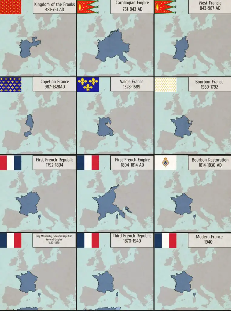
4. The Changing Shape of France
The maps below show how France’s borders have changed over the centuries, from early medieval expansion to Napoleonic conquests and post-war adjustments.
5. How Long Was Your Region Part of France?
This map breaks down European regions based on how long they were ruled by France. Some territories were part of the country for centuries; others, only briefly during military campaigns or shifting alliances.

6. All Countries Invaded by France
Few nations have had as much military influence as France. The map below shows countries France has invaded at some point in history.

7. Where Do the French Live?
Reddit user Calvein created this creative population density map using real INSEE data. Instead of using color gradients, it mimics elevation lines (like a Joy Division album cover) to show where people are concentrated. Paris and a few key urban centers dominate.

8. River Basins of France
Geographer Milos Popovic designed this map to show the country’s major watersheds, including the Seine, Loire, Garonne, and Rhône. Understanding these drainage basins is essential for grasping how French agriculture, industry, and settlements evolved.

9. The Coasts of France and Their Names
France’s three coastlines—Atlantic, Mediterranean, and Channel—are dotted with regions that each have their own character and even their own names. From the Côte d’Azur to the Opal Coast, these areas are important both for geography and tourism.

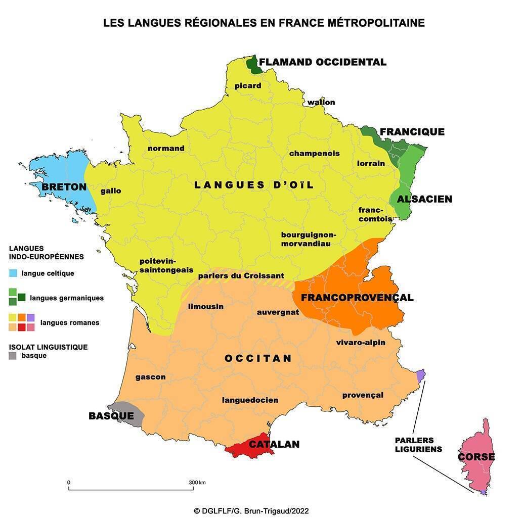
10. Regional Languages in France
While French is the official language, regional languages like Breton, Occitan, Alsatian, and Corsican are still spoken and protected. A linguistic map below shows where these languages are (or were) most commonly spoken, offering insight into France’s cultural diversity.
11. Pain au Chocolat vs Chocolatine
The country is split over what to call a chocolate-filled pastry. In most of France, it’s pain au chocolat—but in the southwest, it’s chocolatine.

12. Wines of France
France’s wine regions are famous worldwide. This map outlines the main appellations—Bordeaux, Burgundy, Champagne, Loire Valley, and more—showing the geographic roots of some of the most celebrated wines.

13. Dividing France by Stereotypes
People have many ways of dividing France—north vs south, urban vs rural, wine vs beer. This humorous map below collects various regional clichés and opinions about cultural divides.

14. Places of Worship in 2024
A recent map of religious buildings shows where Catholic and Protestant places of worship are located across France. It reflects not just current demographics but also historical divisions, especially post-Reformation.

15. Forest Cover Then and Now
Comparing France’s forest coverage in the 18th century versus 2020 shows a major increase. After centuries of deforestation, reforestation and conservation have reversed the trend.

16. Solar and Wind Energy Potential in France

France is endlessly complex, and maps like these help make sense of it all, from ancient rivers to modern pastries. If you’ve come across any other fascinating or creative French maps, feel free to share them in the comments—I’d love to see them.


