Imagine an Amsterdam without its iconic canals, where highways slice through historic neighborhoods, and monorails whisk commuters between towering skyscrapers. This wasn’t a dystopian nightmare, but a very real proposal for the Dutch capital’s future in the 1960s.
Enter the Jokinen Plan, a radical vision for Amsterdam conceived by American traffic expert David A. Jokinen in 1967. At a time when the automobile reigned supreme and suburbs were booming, city planners looked to the United States as a model for urban development. Jokinen’s proposal aimed to transform Amsterdam into a car-centric metropolis fit for the year 2000.
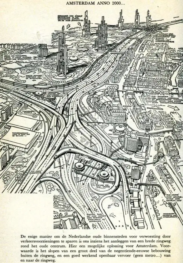
Here’s a map of Amsterdam in 2000 according to the Jokinen plan.
Key elements of the Jokinen Plan included:
Filling in the Singelgracht canal to create a six-lane highway circling the city center.
Demolishing working-class neighborhoods like De Pijp and Kinkerbuurt to make way for a major highway (the “Southern Access Road”) and a new central business district.
Constructing high-rise office towers inspired by La Défense in Paris.
Building a new central railway station near Weteringcircuit.
Implementing a monorail system to connect parking garages on the outskirts with the old city center.
The plan assumed that most residents would live in the suburbs and commute to work by car, mirroring trends in American cities. While it did consider public transport, the focus was overwhelmingly on facilitating automobile access to the city center.
Fortunately for Amsterdam, the Jokinen Plan met fierce opposition from citizens and was largely abandoned. However, its influence can still be seen in some of the city’s wider boulevards and viaducts constructed during that era.
The rejection of this car-centric vision marked a turning point for Amsterdam. Instead of demolishing neighborhoods and building highways, the city began to prioritize cycling, walking, and public transit. This shift in urban planning philosophy has made Amsterdam one of the most livable and bicycle-friendly cities in the world.
Today, as cities globally grapple with the consequences of car-dependent development, Amsterdam stands as a shining example of an alternative path. The story of the Jokinen Plan serves as a reminder of how close the city came to a very different future – and how citizen activism helped preserve the Amsterdam we know and love today.
As we reflect on this pivotal moment in urban planning history, we’re left to wonder: What other cities might follow in Amsterdam’s footsteps, choosing people-centric design over automobile dominance?
Interested in exploring more about the Netherlands and Amsterdam? Check out these maps available on Amazon:


")


