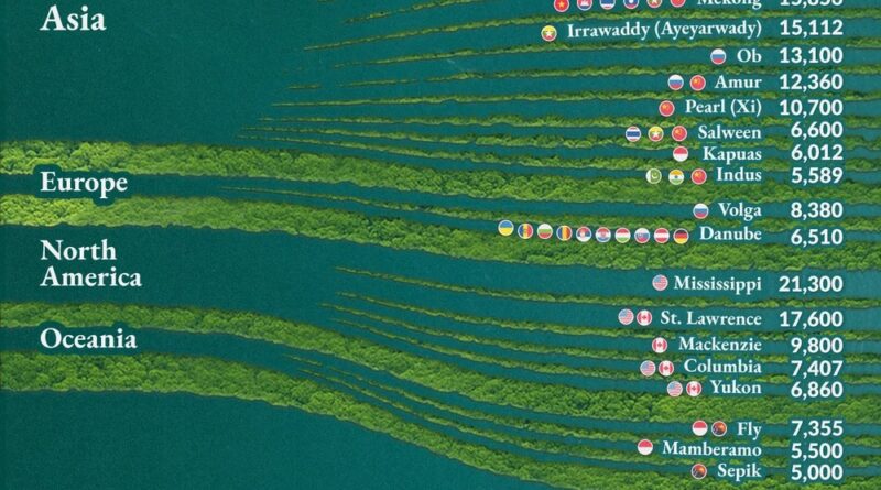
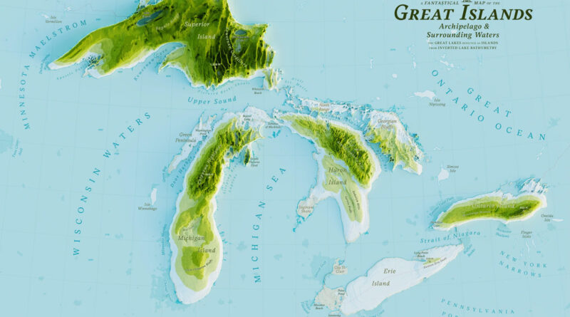
Water Bodies

NewsVivid mapsWater Bodies

Exploring the Rivers and Basins of North America

The rivers of North America are diverse and dynamic, ranging from the mighty Mississippi and its extensive basin to the vast, icy waters of the Mackenzie. They shape the continent’s landscapes, support rich ecosystems, and serve as crucial resources for human activities. These rivers vary greatly in length, flow rate, and basin size, reflecting the continent’s wide range of climates and geographies.

Read More
Water Bodies

World Map of Ocean Salinity

Dive into the salty world of ocean salinity! This post explores how salt concentrations vary across our planet’s seas, featuring world maps that reveal fascinating patterns. Learn about the saltiest bodies of water, how salinity has changed over time, and why this matters for our planet’s climate and ecosystems.

Read More
Water Bodies

The lost rivers of London

London was historically crisscrossed by numerous rivers and streams that played a crucial role in its development and growth. However, as the city expanded, many of rivers were covered, redirected, or built over. It is estimated that there were about 20 significant rivers that have been covered or built over in London.

Read More
NewsVivid mapsWater Bodies

Maps of the Great Lakes

The Great Lakes are the most extensive freshwater system globally (94,600 sq mi / 244,000 sq km). The Lakes contain 5,400 cu mi (22,500 cu km) of surface freshwater on earth or 6 quadrillion gallons of freshwater (22.7 quadrillion liters), accounting for about 21% of the world’s surface freshwater or 84% of North America’s surface freshwater.

Using Digital Elevation Model data, I made the map of the Great Lakes in watercolor style.

Read More