The Great Lakes are the most extensive freshwater system in the world. The 5 Great Lakes: Superior, Huron, Michigan, Ontario, and Erie span a combined surface area of 94.6 thousand square miles (244 thousand sq km) and are all united by many rivers and lakes, making the Great Lakes among the world’s 15 largest lakes. The Great Lakes comprise 21 percent of the earth’s surface freshwater by volume, or 84 percent of the surface freshwater in North America.
Below is the map of the Great Lakes in watercolor style made using Digital Elevation Model data.
By the saturation of the blue color, you can see that the deepest lake is Superior. Erie has the least mean depth of the Great Lakes.
The Great Lakes’ surface area is more extensive than Connecticut, Massachusetts, New Hampshire, New Jersey, New York, Rhode Island, and Vermont combined.
The Lakes contain 5.4 thousand cubic miles (22.5 cubic kilometers) of surface freshwater on Earth or six quadrillion gallons of fresh water (22.7 quadrillion liters), accounting for about 21 percent of the world’s surface freshwater or 84 percent of North America’s surface freshwater or more than 90 percent of the surface freshwater in the U.S. This amount of water enough to sink the whole continental United States in approximately 10 feet of water (~3 meters).
The Great Lakes shoreline’s total length, including islands, is about 11 thousand miles; a 6500-mile drive tour around the lakes takes not a single day.
The Great Lakes comprise more than 35,000 islands. The largest is Manitoulin, located in Lake Huron. At 1068 sq mi (2766.1 sq km), it is the largest freshwater lake island globally and has about 12.6 thousand citizens. On Lake Huron, Georgian Bay comprises approximately 17.5 thousand islands, while the archipelago in the St. Lawrence River, known as the Thousand Islands, actually houses about 1.8 thousand islands.
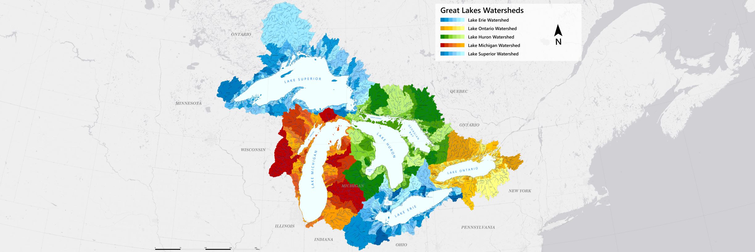
Despite the immense size of the Great Lakes, the watersheds that feed them are comparatively small. This is because a significant portion of the water in the Great Lakes comes directly from precipitation falling onto the lakes’ surfaces rather than from runoff from surrounding land.
The relatively small watershed size is one of the factors contributing to the unique hydrological characteristics of the Great Lakes, including their clarity, water levels, and response to changes in weather patterns. The map below created by Fred A. and Barbara M. Erb Family Foundation shows Great Lakes Watersheds.
Nearly 34 million people in the U.S. and Canada live in the Great Lakes basin — 8% of the U.S. population and approximately 32% of Canada’s population. And for more than forty million people, The Great Lakes is the principal water source.
Approximately 25 percent of Canadian agricultural production and 7 percent of American farm production depend on the Great Lakes’ water.
A geologically recent system compared to the global oceans, the Great Lakes were formed by glaciers approximately 10 thousand years ago.
Each Lake Name is obtained from both native American languages or French.
Length: 350 miles (563 kilometers) Width: 160 miles (257 kilometers) Elevation: 600 feet (183 meters) Depth: 483 feet (147 meters) average; 1,333 feet (406 meters) maximum Volume: 2,900 cubic miles (12,100 cubic kilometers) Water surface area: 31,700 square miles (82,000 square kilometers) Catchment drainage basin area: 49,300 square miles (128,000 square kilometers) Shoreline length: 2,726 miles (4,385 kilometers), including islands Outlet: St. Marys River to Lake Huron Residence time: 191 years The U.S. population: 0.5 million Canada population: 0.2 million
Lake Superior is by significantly the biggest and most in-depth. Spanning nearly 31.7 thousand square miles (51.5 sq. km), Lake Superior is the largest freshwater lake on the planet by surface area.
This lake holds half of the water in all the Great Lakes (~2.9 thousand cubic miles or 12.1 thousand cubic kilometers of water).
The Empire State Building would sink under Lake Superior’s surface because its deepest point is 1,330 feet (~405 meters). For comparison, the Empire State Building is 1,250 feet (~381 meters) tall from the ground to the roof.
The lake’s name comes from the French word lac supérieur, meaning upper lake, as it is located north of Lake Huron.
Lake Michigan
Length: 307 miles (494 kilometers) Width: 118 miles (190 kilometers) Elevation: 577.5 feet (176 meters) Depth: 279 feet (85 meters) average; 923 feet (281 meters) maximum Volume: 1,180 cubic miles (4,918 cubic kilometers) Water surface area: 22,300 square miles (57,753 square kilometers) Catchment drainage basin area: 45,600 square miles (118,095 square kilometers) Shoreline length: 1,640 miles (2,639 kilometers), including islands Outlet: Straits of Mackinac to Lake Huron Residence time: 99 years The U.S. population: 12.2 million
Lake Michigan is the only Great Lake that is wholly inside United States territory.
Lake Michigan is the second-largest of the Great Lakes by volume and is joined to Lake Huron by the Straits of Mackinac between Michigan’s upper and lower peninsulas.
It has a unique water flow that goes in almost a dead-end formation, moving slowly in a circular pattern. According to the University of Wisconsin, Michigan and Huron are two halves of one water body.
Lake Michigan’s beach is home to the largest freshwater sand dunes in the world.
The lake’s name is obtained from the Ojibwa Indian word ‘mishigami’, meaning “large lake.” However, it is only the third largest of the Great Lakes when measured by water surface (22,300 square miles / 57,800 square km).
Lake Huron
Length: 206 miles (332 kilometers) Width: 183 miles (295 kilometers) Elevation: 577.5 feet (176 meters) Depth: 195 feet (59 meters) average; 750 feet (229 meters) maximum Volume: 849 cubic miles (3,543 cubic kilometers) Water surface area: 23,007 square miles (59,588 square kilometers) Catchment drainage basin area: 51,700 square miles (134,100 square kilometers) Shoreline length: 3,830 miles (6,164 kilometers), including islands Outlet: St. Clair River to Lake Erie Residence time: 21 years The U.S. population: 1.6 million Canada population: 1.6 million
Lake Huron is the second-largest Great Lake by surface area (23,000 square miles / 59,600 square km) and has the longest shoreline (3,827 miles / 6,157 km), taking into account its many islands.
Lake Huron is named for the Wyandot Indians, or Hurons, who existed there.
Lake Ontario
Length: 193 miles (311 kilometers) Width: 53 miles (85 kilometers) Elevation: 243.3 feet (74.2 meters) Depth: 283 feet (86 meters) average; 802 feet (244 meters) maximum Volume: 393 cubic miles (1,640 cubic kilometers) Water surface area: 7,340 square miles (19,003 square kilometers) Catchment drainage basin area: 24,720 square miles (64,000 square kilometers) Shoreline length: 712 miles (1,146 kilometers), including islands Outlet: St. Lawrence River to the Atlantic Ocean Residence time: 6 years The U.S. population: 2.8 million Canada population: 2.8 million
Lake Ontario is the least of the Great Lakes when measured in surface area (7,340 square miles / 19,003 square km). While it is similar in length and width to Lake Erie, it is much deeper and contains around 4 times the water volume (393 cubic miles/1,640 cubic km). Located downstream from Lake Erie, Lake Ontario is at the base of Niagara Falls.
Ontario is the Huron word for “lake of shining water.”
Lake Erie
Length: 241 miles (388 kilometers) Width: 57 miles (92 kilometers) Elevation: 569.2 feet (173.5 meters) Depth: 62 feet (19 meters) average; 210 feet (64 meters) maximum Volume: 116 cubic miles (480 cubic kilometers) Water surface area: 9,910 square miles (25,657 square kilometers) Catchment drainage basin area: 22,700 square miles (58,788 square miles) Shoreline length: 871 miles (1,402 kilometers), including islets Outlets: Niagara River and Welland Canal Residence time: 2.6 years U.S. population: 10.8 million Canada population: 2.0 million
Lake Erie is the fourth largest of the Great Lakes when measured in surface area (9,910 square miles / 25,657 square km.) and the smallest by water volume (116 cubic miles / 484 cubic km).
The lake’s name was obtained from the Iroquoian word for “long tail,” which describes its configuration.


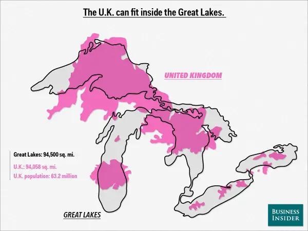
The United Kingdom Compared To The Great Lakes