Many people consider the Mediterranean climate among the most comfortable for human life: summers are warm and reliably dry, winters are mild and rainy, and the range of temperatures is often gentle compared with continental or tropical climates. That sense of comfort shows up in travel writing, horticulture and how people choose where to live.
WHAT IS A MEDITERRANEAN CLIMATE?
A Mediterranean climate (Köppen types Csa and Csb) is defined by a seasonal rainfall pattern: most precipitation falls in cool months, while summers are dry. It’s typically found on the western sides of continents between about 30° and 45° latitude (north and south). That regular seasonality – wet winters, dry summers – shapes both natural vegetation and farming choices.
This particular seasonal rhythm favors a distinctive set of plant communities: drought-tolerant shrubs and small trees, woodlands with hard, leathery leaves, and plants adapted to occasional fires. Those plant communities, taken together, are often called “Mediterranean-type biomes” or “Mediterranean forests, woodlands and scrub.” The same climate pattern shows up in five widely recognized regions on four continents and one island-rich subregion.
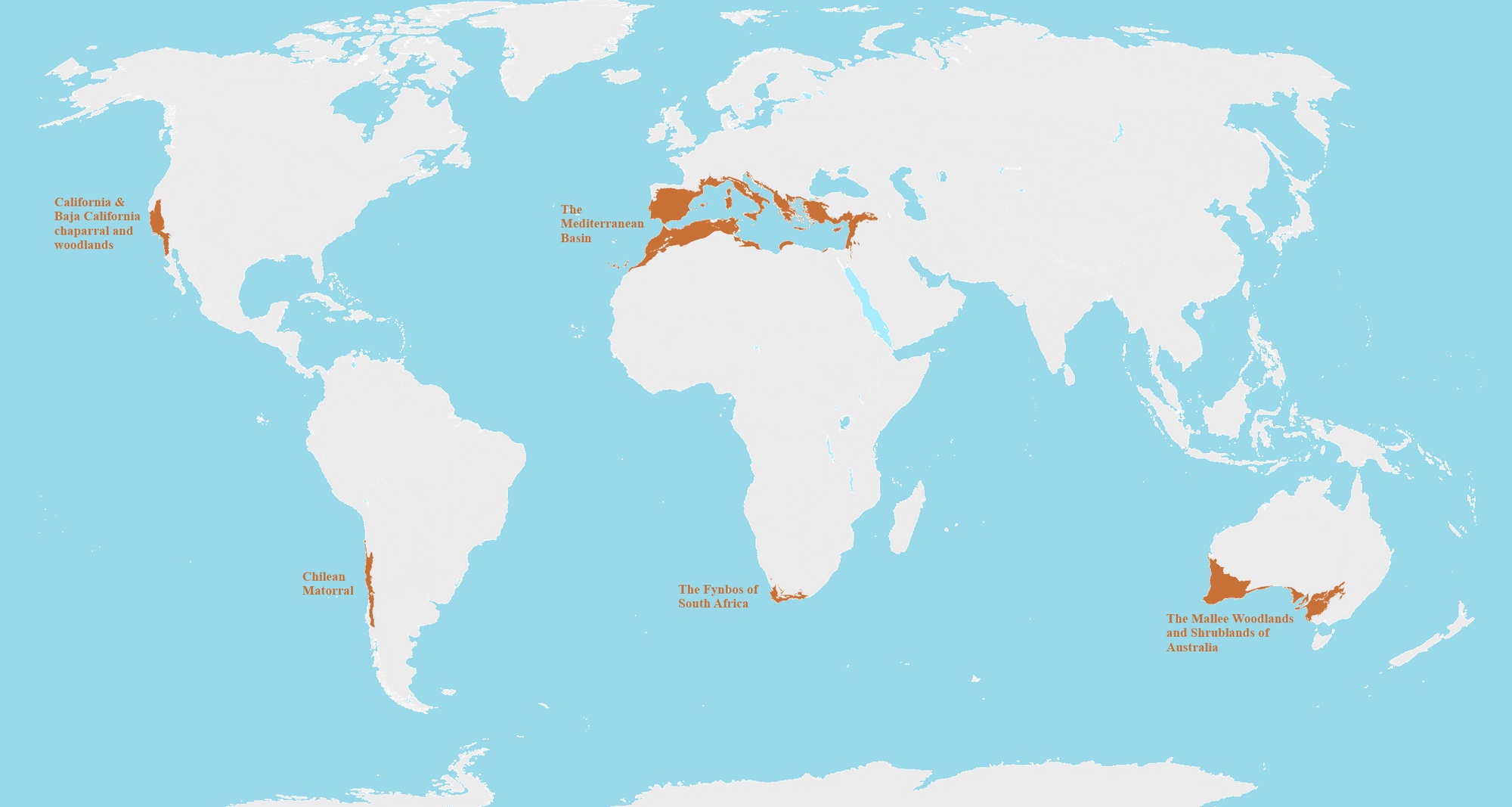
It’s easy to assume “Mediterranean” means only the lands ringing the Mediterranean Sea. But the climate pattern repeats elsewhere — and when it does, similar-looking vegetation develops, even though the species are different. Below is the world map created by Reddit user Simple_Pension_1330 that shows Mediterranean biomes around the world.
Mediterranean region
Approx. latitude
Principal countries / regions
Area (km²)
Area (mi²)
Mediterranean Basin
~30°–45° N
Southern Europe, North Africa, Levant (e.g., Spain, France, Italy, Greece, Turkey, Morocco, Algeria, Tunisia, Libya, Israel, Lebanon, Syria)
2,085,292 km²
805,136 mi²
California & Baja California (chaparral & woodlands)
~32°–42° N
Western U.S. (California, parts of Oregon), northwestern Baja California (Mexico)
121,000 km²
46,718 mi²
Chilean matorral
~32°–37° S
Central coastal Chile
148,500 km²
57,336 mi²
Cape Floristic Region (fynbos)
~32°–34° S
Southwestern South Africa (Western Cape and parts of Eastern Cape)
~78,555 km²
30,330 mi²
Mallee woodlands & shrublands (Australia)
~29°–36° S
Southern Australia (South Australia, Victoria, parts of New South Wales and Western Australia)
~214,000 km²
~82,626 mi²
Mediterranean Basin
This is the largest of the five regions and one of the planet’s major biodiversity hotspots. It supports a huge number of endemic plants and a long history of grazing, orchards and mixed farming. The landscape you picture – terraced hills, olive groves, and coastal scrub – is the result of climate interacting with civilizations over millennia.
California & Baja California
California’s chaparral and oak woodlands are classic examples of plants shaped by dry summers and fire. The region is easy to recognize from photos: dense, shrubby hills and oak-studded slopes. Because many towns and cities press up against these wildlands, fire management is a recurring social and ecological problem.
Chilean matorral
The matorral sits in a narrow coastal band that’s squeezed between the Atacama Desert and cooler temperate forests to the south. It’s the only major Mediterranean-type region in South America and contains many local endemic plants and animals adapted to seasonal drought.
Cape Floristic Region (fynbos)
The Cape floristic province is small compared with the Mediterranean Basin or Australia’s mallee, but it is immensely rich in plant species – thousands of them, with a very large percentage found nowhere else. The fynbos vegetation is fire-prone and botanically famous; the region is protected in part as a UNESCO World Heritage Site.


?")


