12 maps that explain the Mediterranean Sea
The Mediterranean Sea has been shaping human civilization and culture for over 10 thousand years. Its exceptional size and structure joins Europe, Asia, and Africa, making the Mediterranean unlike any other water body found on the planet. Throughout much of ancient history, the Mediterranean was used by different civilizations to communicate, travel, trade, and wage war.
The Mediterranean Sea is a sea almost entirely encircled by land and connected to the Atlantic Ocean. It includes an area of approximately 2.5 million square kilometers (970 thousand sq mi), but its connection to the Atlantic Sea through the Strait of Gibraltar is only 14 kilometers (9 miles) wide.

The Mediterranean Sea has an average depth of 1.5 kilometers (0.9 miles), and the deepest registered point is 5,3 kilometer (3,3 miles) in the Calypso Deep positioned in the Hellenic Trench (Ionian Sea).

Sicily is the largest island in the Mediterranean Sea. The total area of Sicily is 25,711 square kilometers or 9,927 square miles.
Sicily is about 3.3 times smaller than Ireland and 0.94 times as huge as Massachusetts. The map below, created by GergoliShellos shows the largest Mediterranean islands.

The Mediterranean Sea was the central superhighway of transportation for traders and explorers of ancient times, facilitating business and cultural interchange connecting peoples incorporating three continents: Southern Europe, Western Asia, and North Africa.

An ancient Semitic-speaking civilization, the Phoenicians would come to develop the first instances of thalassocracy, colonization, and city-states. Originating from the area we today call Lebanon in the Levant, the Phoenicians relied heavily on maritime trade. Made possible by the famous Lebanese cedar tree timber. As a crossroad between the Egyptians, Hittites, and Mesopotamians, they used their mastery of sail to introduce many diverse goods into the ancient Mediterranean. Wares such as wine, glass, and chased metalwork.

Their perhaps most incredible legacy would be their influence on Greeks. The Ancient Greeks practically invented Western culture.
The ancient Greeks were active seafarers searching opportunities for trade and establishing new independent cities at coastal sites across the Mediterranean Sea.
The Odyssey is one of the first adventure novels in the history of humanity and a kind of encyclopedia of geographical representations of the ancient Greeks. Nowadays, Odysseus is represented as a famous and even archetypal traveler. The map below, created by World History Encyclopedia, shows an estimated map of Odysseus’s 10 year journey during the events of the Odyssey.

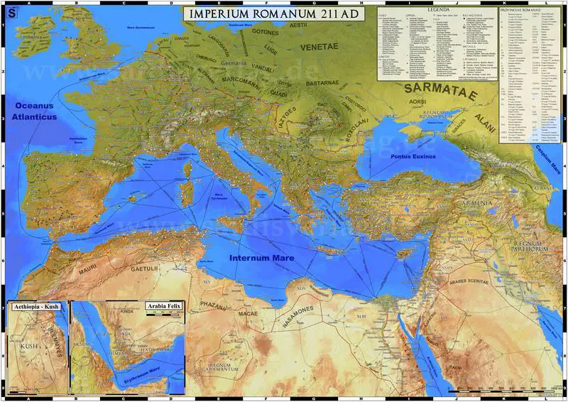
Greek culture influenced the Roman Empire and many other civilizations. The map below shows trade routes and principal products in the Roman Empire. These trade routes were the channels through which the culture of the Roman Empire spread to Europe.

The Roman Empire controlled the sea for many centuries.

The history of the Mediterranean region is essential for explaining the roots and evolution of many contemporary societies.
In the Mediterranean region, approximately 13 languages are officially spoken. An additional 8 languages are broadly spoken unofficially in countries bordering the Mediterranean Sea.
| Language | Country |
|---|---|
| Albanian | Albania |
| Arabic | Syria, Lebanon, Palestine, Egypt, Algeria, Tunisia, Morocco, Israel (unofficial), Libya (unofficial) |
| Croatian | Croatia, Bosnia (unofficial) |
| English | Malta, Gibraltar (UK), Lebanon (unofficial) |
| French | France, Monaco, Lebanon (unofficial), Algeria (unofficial), Tunisia (unofficial), Morocco (unofficial) |
| Greek | Greece, Cyprus |
| Hebrew | Israel |
| Italian | Italy, Libya (unofficial) |
| Maltese | Malta |
| Serbian | Montenegro, Bosnia (unofficial) |
| Slovenian | Slovenia |
| Spanish | Spain |
| Turkish | Turkey, Cyprus |
| Aramaic | Syria (unofficial) |
| Armenian | Syria (unofficial) |
| Basque | France (unofficial), Spain (unofficial) |
| Berber | Algeria (unofficial), Morocco (unofficial) |
| Bosnian | Bosnia (unofficial) |
| Catalan | Spain (unofficial) |
| Galician | Spain (unofficial) |
| Kurdish | Syria (unofficial), Turkey (unofficial) |
But many languages, unfortunately, have not survived to this day. Below is the map created by the Reddit user associationcortex that shows extinct languages of the Mediterranean.

Each of the Mediterranean contemporary societies boasts a unique cuisine.

Today, 21 countries surround the Mediterranean sea, and 285 cities with more than 100,000 inhabitants are located in the Mediterranean region, 18 of which have a population of more than one million. All Mediterranean cities represent more than 126 million residents.

Geological data shows that about 5.9 million years ago, the Mediterranean was separated off from the Atlantic Ocean and was drained over some 0.6 million years before being refilled by the Zanclean flood about 5.3 million years ago.
One hundred years ago, there was a plan for dams construction (‘The Atlantropa project’), which would have led to the lowering of the sea level of the Mediterranean Sea by 200 meters (660 ft), opening up vast new areas for settlements.


