When we think of North America, images of vast landscapes and sprawling cities often come to mind. But there’s another dimension to this continent that’s equally captivating – the vertical one. The skylines of major cities across the U.S. and Canada tell a fascinating story of urban development, economic shifts, and architectural ambition.
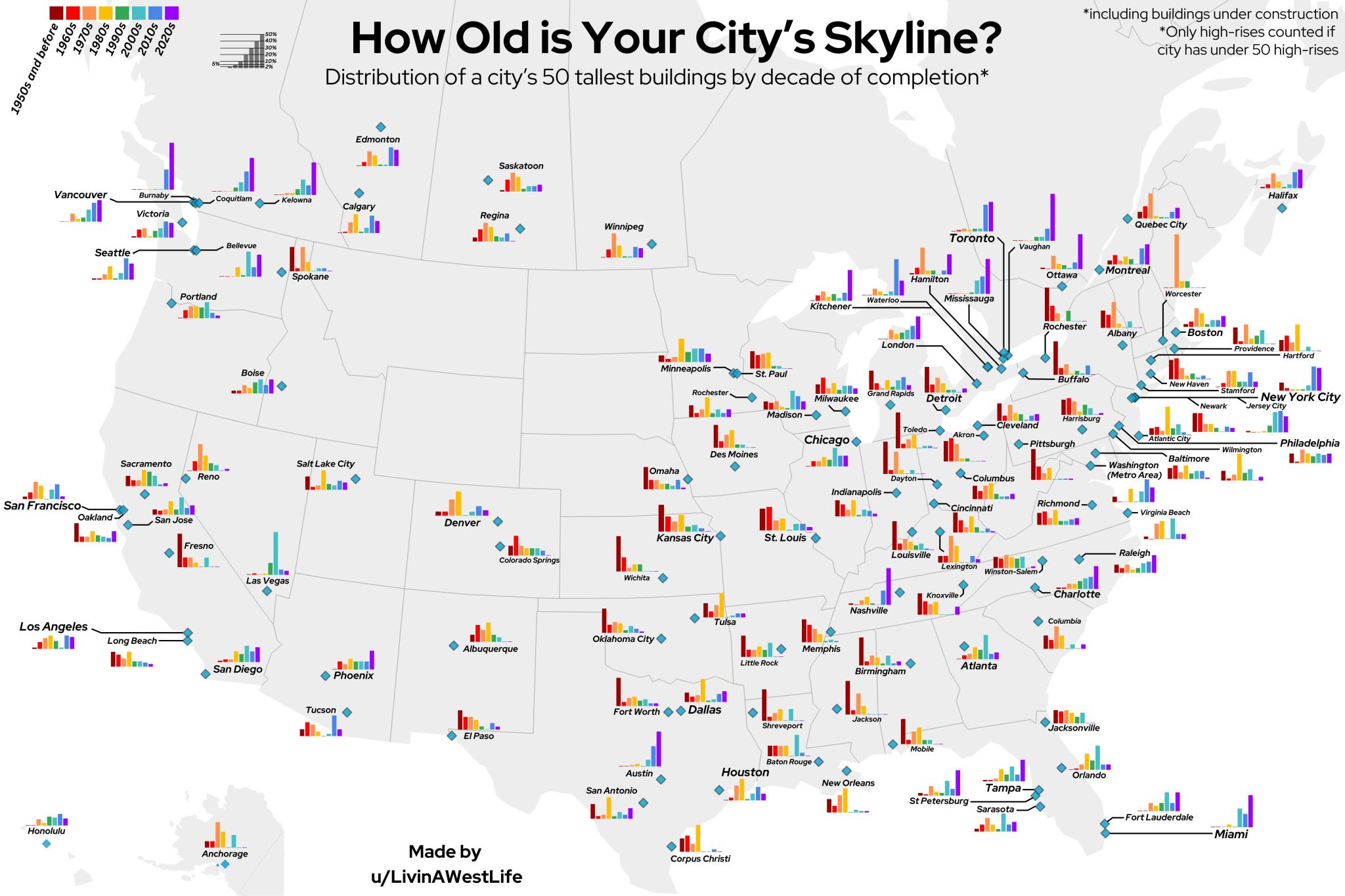
Recently, I came across an intriguing map created by Reddit user LivingWestLife that beautifully illustrates the age of skylines across North America. This eye-opening visualization gives us a unique perspective on the evolution of our cities.
Let’s break down what we’re seeing in this map of North America:
The Aging Giants: Many smaller American cities, especially in the Rust Belt, sport skylines that have seen better days. The predominance of brown and red in their bar charts indicates that their tallest buildings are relatively old. This reflects the economic boom these cities experienced in the early to mid-20th century, followed by periods of slower growth.
The Contrast Across the Lakes: One of the most striking features of this map is the stark contrast between the U.S. and Canadian sides of Lake Ontario and Lake Erie. While American cities on the southern shores show older skylines, their Canadian counterparts to the north boast much newer high-rises, as indicated by the blue and purple hues in their charts.
The New Boom Towns: Not all American cities are stuck in the past. The map highlights several U.S. cities experiencing a skyscraper boom, including Austin, Nashville, Charlotte, Seattle, Raleigh, Tampa, and even the ever-evolving New York City. These cities show a predominance of blue and purple in their charts, indicating a wealth of recently constructed tall buildings.
Canadian Ascendance: It’s impossible to ignore the youth of Canadian skylines. Cities like Toronto, Vancouver, and Calgary are awash in cool colors, showcasing their relatively recent rise to prominence on the global stage. This reflects Canada’s growing economic power and increasing urbanization in recent decades.
The Outliers: Some cities buck the trends of their regions. For instance, Miami stands out among East Coast cities with its predominantly newer skyline, likely due to its more recent emergence as a major international city and its unique real estate market.
What’s particularly fascinating about this visualization is how it reflects broader economic and demographic trends across North America. The shift from manufacturing to service and tech-based economies, the rise of sunbelt cities, and the increasing prominence of Canadian metropolises are all captured in these simple bar charts.
It’s worth noting that this map doesn’t just show us where the tall buildings are – it gives us insight into the economic health and vibrancy of these urban centers. A city with a lot of recent skyscraper construction is likely to experience strong economic growth and attract significant investment.
However, it’s also important to remember that the age of a skyline doesn’t necessarily correlate with a city’s overall modernity or livability. Many cities with older skylines have undergone extensive renovations and adaptive reuse projects, breathing new life into their historic structures.
As we look to the future, it will be interesting to see how these skylines continue to evolve. Will we see more growth in the Sunbelt and West Coast cities? Will Canadian metropolises continue their upward trajectory? And what about the cities with older skylines – will they experience a renaissance of their own?
This map of North America’s skylines serves as a fascinating snapshot of urban development across the continent. It reminds us that our cities are living, breathing entities, constantly changing and adapting to the needs and aspirations of their inhabitants.
For those interested in exploring this topic further, I highly recommend the following resources: