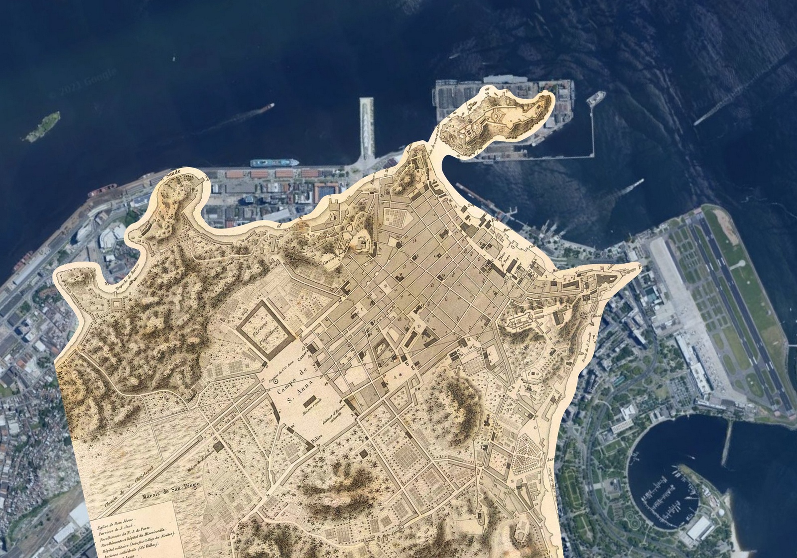
Rio de Janeiro is a city that has been reshaped over centuries—not just culturally and architecturally, but also in its very geography. The map you’ve come across, overlaying an 1820s version of Rio onto the present-day city, is a fascinating way to visualize just how much the coastline and urban landscape have changed. Large portions of what is now central Rio were once water, later reclaimed through ambitious landfills and construction projects.
Mind-bending overlay of 1820s Rio (sepia) on today’s satellite view. Where ships once sailed, planes now take off from Santos Dumont Airport. The contrast reveals just how much of modern Rio was underwater two centuries ago.
The transformation of Rio tells a story of remarkable growth. From a modest colonial city of about 50,000 inhabitants in 1820, Rio exploded to reach 1.2 million by 1940 and now houses over 6.7 million people in the city proper, with the metropolitan area approaching 13 million. This massive population growth drove the city’s physical expansion, pushing it to claim more land from the sea.
The city’s ethnic composition reflects waves of history: indigenous Tupi people were joined by Portuguese colonizers, followed by enslaved Africans who made up nearly half the population by the 1800s. The late 19th and early 20th centuries brought new waves of European immigrants, particularly from Portugal, Italy, and Spain. Today, Rio is one of Brazil’s most diverse cities, with residents identifying as pardos (mixed-race) 39%, white 51%, black 9%, and Asian or indigenous making up the remainder.
Look at the port area in the north of the overlay. Everything beyond those neat colonial-era blocks was underwater. Today it’s home to container ships and warehouses. The most dramatic change? Flamengo. The historic map shows waves lapping at the shore where today you’ll find one of Rio’s most popular parks. Imagine telling a sailor from 1820 that people would be playing soccer and jogging where they once navigated their ships!
The patterns of development in the city convey a distinct narrative. The original colonial core, visible in the map’s orderly grid, expanded through successive waves of urbanization. The wealthy gradually moved south to neighborhoods like Botafogo and Copacabana (both partially built on reclaimed land), while working-class communities grew in the north. The hills (morros) shown on the old map, once largely uninhabited, now host both upscale neighborhoods and favelas, informal settlements that began appearing in the late 1800s and now house nearly a quarter of Rio’s population.
This growth came at an environmental cost. Many of the mangroves and natural beaches shown on the 1820s map were sacrificed for urban development. The original coastline was pushed back hundreds of meters in some places, with major landfill projects continuing well into the 20th century. The city’s total area has grown from roughly 20 square kilometers (7.7 sq mi) in the 1820s to over 1,200 square kilometers (463 sq mi) today, though much of this expansion was inland rather than into the sea.
Looking at this overlay makes me wonder: what would those 1820s mapmakers think if they could see Rio today? And what will Rio look like 200 years from now, especially as we face rising sea levels? The ocean gave up this land once – will it want it back?
What changes in your city have surprised you the most? Have you seen similar transformations in other coastal cities? Drop a comment below – I’d love to hear your thoughts!