The Roman Empire at its Territorial Height
The Roman Empire, one of history’s most influential civilizations, reached its largest territorial expanse during the reign of Emperor Trajan (AD 98–117). At its peak, it encompassed an impressive area of about 5 million square kilometers (1.93 million square miles), stretching from Britain to the Euphrates and from the Rhine to North Africa.
The maps below show The Roman Empire at its territorial height.
Table of Contents
The Geography of Roman Power
The Roman army mainly was infantry based, which was great in hilly or mountainous terrain but at a critical disadvantage to cavalry on the open flats. As a result, the Roman Empire’s frontiers were mainly situated on one of the following:
- Coast (the entire Mediterranean basin, Iberia, most of northern and western Europe)
- Mountains (Balkans, Alps, north-western Africa, Anatolia in modern Turkey, Middle East)
- Desert (northeastern Africa and the Arabian peninsula)
Any of the above is an efficient barrier to the tactical movement and logistical mobility and supply of large cavalry-based armies, the curse of the Roman army during its existence, and the reason for some of its most dramatic losses, from Cannae to Carrhae.
Behind tactical considerations, swaths of rough territory also give a natural geographic constraint to population density overall. On such edges, the Romans were less likely to have a lot of the enemy population dwelling close to the border, to begin with, suggesting a thinly stretched garrison could protect a large part of the border as far as local border clashes went, while also having more time to prepare a response to any large attacks before they could breach the guarded perimeter.
Below is the fantastic relief map of the Roman Empire created by @mappdoutofficial.

Whenever the Romans had an extent of the border that didn’t meet at least one of the above criteria, they had a permanent source of trouble that they couldn’t permanently resolve. So any conquest just pushed the boundary a bit further without really excluding the threat, only over-stretching their supply lines in the process. In the Eastern territories of the Empire, almost all of those affected losses to cavalry and especially cavalry archers, so the final abandonment of most of Mesopotamia east of Anatolia and the Levant. The other territories with flat, poorly defensible land boundaries linked with powerful enemies were the extents of Dacia and Germania, which unsurprisingly are the positions from where Rome was finally invaded and defeated by the Huns and Goths. But unlike Mesopotamia, Roman Empire couldn’t retire from these boundaries without compromising the defending line and territorial integrity of the whole Empire, so they had no option but to stay.
The just notable exemption to this rule is Britannia, where, opposed to the general style of the Romans, they did well in the English plains yet couldn’t capture the Scottish Highlands. But in the whole system of things, this exemption is rare enough to explain the rule and was possibly driven by logistical and economic factors (too far-off and not deserving the trouble) rather than military considerations.
The map below shows the Roman Empire in 117 AD at its territorial height at Trajan’s death.
The Roman Empire in 117 AD
The Roman Empire in 117 AD, at its territorial zenith under Emperor Trajan, was a vast and diverse realm spanning three continents. It encompassed the entire Mediterranean basin, stretching from Britannia in the northwest to Egypt in the southeast, and from Hispania in the west to the Euphrates River in the east. This period marked the empire’s greatest extent, with a land area of approximately 5 million square kilometers (1.93 million sq m).

The empire included a wide array of cultures, languages, and landscapes, from the forests of Germania to the deserts of North Africa. Major cities like Rome, Alexandria, and Antioch served as centers of commerce, culture, and administration. The Pax Romana, or Roman Peace, ensured relative stability and prosperity across much of this territory, facilitating trade, cultural exchange, and infrastructure development. However, this expansive empire also faced significant challenges in maintaining its borders, particularly along the Rhine and Danube rivers in the north and the Parthian frontier in the east.
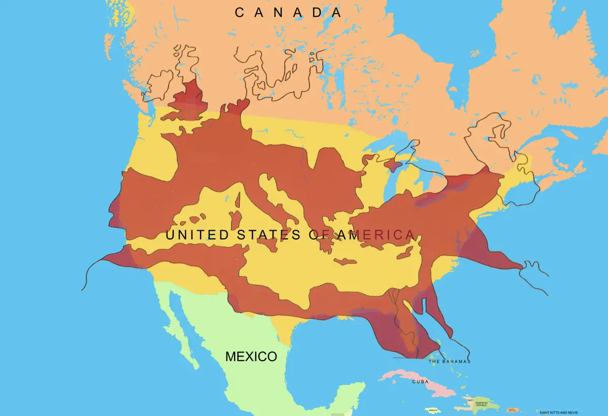
The map below shows the Roman Empire, at its height, overlying on current political borders.

For scale, the Roman Empire at its peak (5 million sq km) was about 62.5% the size of the contiguous United States (8.0 million sq km).
Below is the interesting map giving created by Arnold Platon, the answer to the question “When standing in Rome, how much Empire is there in each direction?”

The Decline and Division
The empire’s golden age began to wane with the rule of Commodus (177–192), marking the onset of a period of instability. Eventually, mounting pressures led to the division of the empire into Western and Eastern halves, each ruled by separate emperors in an attempt to manage the vast territory more effectively.
Explore More Roman History and Geography
Interested in delving deeper into the fascinating world of the Roman Empire? Check out these related products:
- Books on Roman History
- Historical Maps and Atlases
- Roman-Themed Board Games and Strategy Games


")
i feel bad for them so ill post a comment. it was pretty cool i guess.:)
What do you mean
yeah what do ya mean
mee too. I want ,starbucks anyone else???
I want Starbucks latte
same ?
I’m doing this because it was for school ;-;
same
me to :/
im mewing
to ,any people said that it is for school.But some of yall really like learning this
you just dont want to admit that you are smart just say u like reading or, just dont say anything .what is the point
same
same
Same my name isn’t even jhon.
I didn’t think that Roman Empire was that big
yes it mas
rumon has a lot of land!
rome
rome ass hole
yore mom
why would you say something like that
also its your mom
i think this is boring probably cause its my school
me to
How do people remember all of this
It’s easy, just take notes!
how are you supposed to remember the notes?!!!
if you take notes, your gonna lose them
This is a great set of representations. It’s also really helpful context for so much of the history that has followed as well as current events, both political and cultural. Thank you!
its really more to learn about Roman,also hi bob.
I really like to learn about the Romans.
B-)
cool
what was rome like at its peak
Dang the roman empire was bigger than i thought, doing this for 7th grade ancient history btw
Yeah. Huge. Especially back then, when distances meant extensive travel time. It wasn’t easy running such a vast empire.
same
This is my favorite map!!
I agree. The author of this map is a genius!
fun
These maps are pretty cool
ep anyone????
:)))))))))))))))))))))))))))
so much…..