Few European countries have experienced such dramatic territorial changes as Poland. In 1619, the Polish-Lithuanian Commonwealth stretched from the Baltic Sea almost to the Black Sea. Today’s Poland occupies just a fraction of that territory, but in a completely different location – shifted westward from its historical lands.
At its peak during the early 17th century, this massive state dominated Eastern Europe. The Commonwealth’s population was remarkably diverse for its time. According to Norman Davies in his book “God’s Playground: A History of Poland” (Amazon link), the realm contained:
5 million Ruthenians (ancestors of modern Ukrainians and Belarusians)
4.5 million Poles
750,000 Lithuanians
750,000 Prussians
500,000 Jews
500,000 Livonians
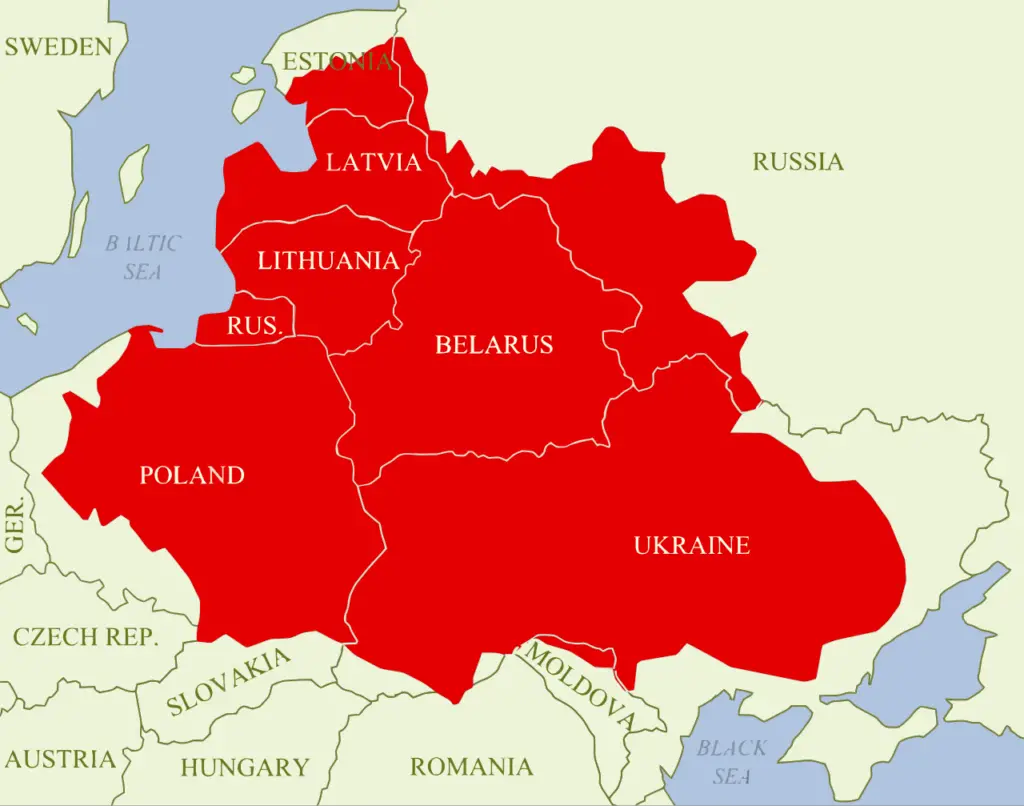
The Commonwealth’s vast territory encompassed lands that today belong to:
Most of modern Poland and Ukraine
All of Belarus and Lithuania
Latvia and the Russian Kaliningrad region
Large parts of Estonia
The Smolensk region of Russia
Small sections of Moldova and Romania
The decline of this powerful state reads like a political thriller. Through a series of wars, invasions, and internal conflicts, the Commonwealth gradually lost its grip on power. The final blow came between 1772 and 1795, when three aggressive neighbors – Russia, Prussia, and Austria – systematically carved up the country in three successive partitions. Poland vanished from European maps for 123 years.
Finally, let’s look at how long different territories have been under Polish control throughout history.
The 20th century brought even more radical changes. After regaining independence in 1918, Poland enjoyed just 21 years of sovereignty before Nazi Germany and the Soviet Union invaded in 1939. The post-World War II settlement completely redrew Poland’s borders, creating what some historians call “Stalin’s great geographical gift” – though it was more of a forced exchange:
Lost: 179,000 km² of eastern territories to the USSR
Gained: 101,000 km² of former German lands in the west
This massive shift westward transformed Poland’s geography:
Major cities like Lwów (now Lviv, Ukraine) were lost in the east
New cities joined Poland in the west: Wrocław (formerly Breslau), Szczecin (Stettin), and Gdańsk (Danzig)
Millions of people were forcibly relocated: Poles moved west from lost eastern territories, while Germans were expelled from newly acquired western lands
Soviet Union (now replaced by Russia, Ukraine, Belarus, and Lithuania on Poland’s borders)
This territorial transformation has left lasting marks on modern Poland. As Timothy Snyder explains in “The Reconstruction of Nations” (Amazon Link), many Polish families still maintain connections to their former eastern homeland, while western regions showcase a fascinating blend of Polish, German, and Soviet-era influences in their architecture and culture.
Want to dive deeper into Poland’s fascinating territorial history? Here are some key dates that shaped the country’s borders:
Key Moments That Reshaped Poland’s Borders:
1635: The Height of Power The Treaty of Stuhmsdorf confirms Poland-Lithuania as one of Europe’s largest states, stretching from the Baltic to the doorstep of the Black Sea. The Commonwealth stands at its territorial peak.
1772: The First Cut Russia, Prussia, and Austria launch their first coordinated attack on Polish territory. The First Partition stripped away 30% of the Commonwealth’s land and population, signaling the beginning of the end for the Polish-Lithuanian state.
1795: A Nation Erased The Third Partition completely erased Poland from the European map. The once-mighty Commonwealth was divided between Russia, Prussia, and Austria. Poland ceased to exist as an independent state for the next 123 years.
1918: Phoenix Rising After World War I and the three partitioning empires’ collapse, Poland regained independence. The Second Polish Republic emerges with borders stretching from Lithuania to Romania, though smaller than the Commonwealth’s peak territory.
1939: Divided Again Nazi Germany and the Soviet Union invade Poland, splitting the country between them under the secret protocols of the Molotov-Ribbentrop Pact. Once again, Poland vanishes from the map.
1945: The Great Shift West After World War II, Poland undergoes its most dramatic territorial transformation. The country literally moves westward, losing eastern territories to the Soviet Union while gaining German lands in the west. This creates what historians often call “Stalin’s zipper” – an entirely new Poland roughly 200 kilometers west of its previous location.
1975: Stabilizing Borders Minor border adjustments with the Soviet Union completed Poland’s post-war territorial settlement. The country’s borders remain largely unchanged for the next several decades.
1989: A New Era As communism falls, Poland regains full sovereignty. While its borders don’t change, it finds itself with entirely new neighbors as the Soviet Union dissolves and Czechoslovakia splits into two countries.
This compressed timeline shows how Poland’s territory has been far from static – shifting, disappearing, and reemerging in different locations over the centuries. Each change brought massive population movements and cultural transformations that continue to influence Polish society today.
The story of Poland’s shifting borders reminds us how fluid European boundaries have been throughout history. While modern Poland occupies only a portion of its historical Commonwealth territory, it has developed its own distinct identity that bridges East and West, ancient and modern.
The commonwealth of Lithuania and Poland was a combination of two great countries, Poland and Lithuania. This post comes across as biased against Lithuania by only referring to this area as Poland !
Lithuania contributed equally if not more to the commonwealth since all of land in Belarus and Ukraine had already been consolidated in the Grand Duchy of Lithuania (GDL) before Poland and Lithuania united in the commonwealth.

")


The commonwealth of Lithuania and Poland was a combination of two great countries, Poland and Lithuania. This post comes across as biased against Lithuania by only referring to this area as Poland !
Lithuania contributed equally if not more to the commonwealth since all of land in Belarus and Ukraine had already been consolidated in the Grand Duchy of Lithuania (GDL) before Poland and Lithuania united in the commonwealth.
Border changes in history of Poland