At the time of European settlement in North America, primary or virgin forests covered nearly all of the East Coast (1 billion acres or 4 million sq. km.). By the end of the twentieth century, virtually no substantial tracts of virgin forests remained in the South. Remnants can be found in protected lands in parts of the Great Smoky Mountains and southwestern Florida, but almost all of the South’s current forested area has been earlier logged.
The map below shows the estimated area of virgin old-growth forests in the U.S. in 1620, 1850, 1920 and nowdays.
Area of Virgin Forest: 1620 vs 1850 vs 1920 vs nowadays
Nowadays, the map of American virgin forests will look like this.
In 1620, the U.S. forest land’s calculated area was one thousand twenty-four million acres, or about 46% of the total land area. Since 1630, approximately 256 million acres of forest land have been transformed into other uses, mainly farming. Approximately 2/3 of the net conversion to other services happened in the second half of the nineteenth century when an average of 13 sq. mi. of the forest was cleared every day for fifty years. By 1920, the forest land area had decreased to approximately 750 million acres, or 34% of the total land area.
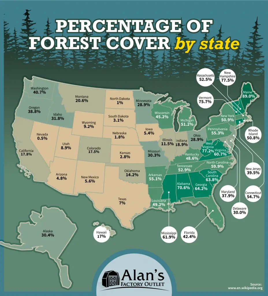
Nowadays, If we consider all forests, 37% of the United States territory (about 1/3 of the U.S.) is forested. Maine has the largest percentage of forested land.
Map of the amount of forest coverage in each U.S. state
Most forested states in the United States: 1. Maine – 89.0% 2. New Hampshire – 77.5% 3. Vermont – 75.7% 4. West Virginia – 77.2% 5. Alabama – 70.6% 6. Georgia – 64.2% 7. South Carolina – 63.8% 8. Mississippi – 61.9% 9. Virginia – 60.7% 10. North Carolina – 59.9%
United States counties by percent forest cover of land area
More than 50% of the forest in the U.S. (441 million acres), mostly found in the east, is owned by some eleven million private ownerships.
United States Forest Ownership
Data: Hewes, Jaketon H.; Butler, Brett J.; Liknes, Greg C. 2017. Forest ownership in the conterminous United States Circa 2014: Distribution of seven ownership types – Geospatial dataset. Fort Collins, CO: Forest Service Research Data Archive.
Very interesting! (but would’ve preferred all maps resized to make the U.S. outline EXACTLY the same size (let the borders bleed out wherever)
Mystified about: Virgin forest seems to have expanded/reappeared diff. places/times:
RE: 1620: (solid forest goes right thru the middle of Lake Tahoe, CA?)
(why no forest at all right on the Gulf coast in either LA or TX in 1620?)
RE: 1850: (big strips ripped thru Cascade Mts.,OR, but south end grows back by 1920?)
(zero forests in 1850’s NV, yet they (re)appear in 1620 & 1920?)
RE: 1920: (large new coastal forest appears in S. Monterey Bay, CA in 1620 not there?)
(Virgin forest strip regrows across mid-FL; more-forested than 1850?)
(Thick Transverse range forests in 1920 not there in 1620 or 1950?)
Possibly what’s on the map is not “Virgin forest”, but “>100yr old Trees”?
Aware some tree species (eastern redcedar) are expanding exponentially in 2023, their tree canopies snuffing out grassland in <40yrs; (Technically = Virgin forest today, right?)
RSVP
Omar Karae El
1 year ago
I was listening to a lecture that mentioned the virgin forest, so I am trying to find where’s it located


Very interesting! (but would’ve preferred all maps resized to make the U.S. outline EXACTLY the same size (let the borders bleed out wherever)
Mystified about: Virgin forest seems to have expanded/reappeared diff. places/times:
RE: 1620: (solid forest goes right thru the middle of Lake Tahoe, CA?)
(why no forest at all right on the Gulf coast in either LA or TX in 1620?)
RE: 1850: (big strips ripped thru Cascade Mts.,OR, but south end grows back by 1920?)
(zero forests in 1850’s NV, yet they (re)appear in 1620 & 1920?)
RE: 1920: (large new coastal forest appears in S. Monterey Bay, CA in 1620 not there?)
(Virgin forest strip regrows across mid-FL; more-forested than 1850?)
(Thick Transverse range forests in 1920 not there in 1620 or 1950?)
Possibly what’s on the map is not “Virgin forest”, but “>100yr old Trees”?
Aware some tree species (eastern redcedar) are expanding exponentially in 2023, their tree canopies snuffing out grassland in <40yrs; (Technically = Virgin forest today, right?)
RSVP
I was listening to a lecture that mentioned the virgin forest, so I am trying to find where’s it located