Europe packs remarkable climate variety into a relatively small area. Mediterranean warmth along the southern coasts. Oceanic mildness across the west. Continental extremes in the east. Subarctic cold across Scandinavia. Alpine tundra in the high mountains. Semi-arid pockets on the Spanish plateau and around the Black Sea.
The Gulf Stream brings warm water northeast from the tropics, so London is milder than Calgary even though it is farther north. Mountains like the Alps and Pyrenees block weather systems, creating wet slopes on one side and dry rain shadows on the other. Your distance from the Atlantic or Mediterranean determines whether you get maritime moderation or the wild temperature swings of a continental interior. Latitude controls how much sunlight reaches you. Latitude affects how much sunlight you get.
These patterns aren’t staying put. I made maps showing how European climate zones have moved since 1930 and where they’re going by 2099. The data comes from Beck et al. (2023) at 1-kilometer resolution. A general northward migration is the current trend. For climate codes and their meanings, check my earlier post on global classifications.
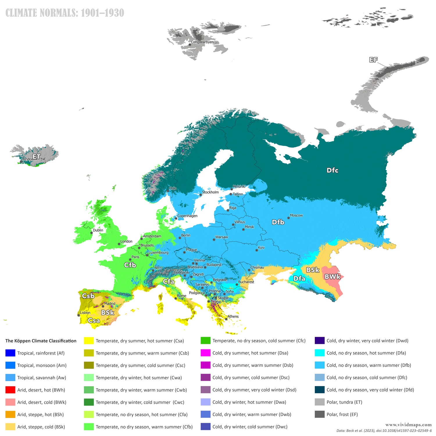
Current climate zones of Europe (1991–2020). Data: Beck et al., 2023.
Today’s map shows what most Europeans recognize. According to the map, Portugal’s coast is surrounded by a Mediterranean climate (Csa, Csb). Oceanic climate (Cfb) blankets Britain, Ireland, France, Western Germany, and the Atlantic-facing coasts. Northern Italy and parts of the Balkans get humid subtropical (Cfa). Central and eastern Europe from East Germany through Poland and into Russia have humid continental (Dfb). Northern Scandinavia and Russia have subarctic (Df). The Alps, Pyrenees, and Carpathians hold cool mountain climates (Cfc) with tundra patches (ET) on the highest summits. Spain’s interior plateau and areas around the Black Sea and Caspian Sea show semi-arid zones (BSk).
The Mediterranean climate has shifted north into southern France and expanded in the Balkans. Oceanic zones have moved into areas that used to be more continental. Humid continental climates have shifted northeast. Subarctic zones in Scandinavia have pulled back northward. Mountain tundra has retreated to higher elevations.
Projections to Century’s End
For the future, I used the most possible SSP2-4.5 scenario where emissions plateau by mid-to-late century.
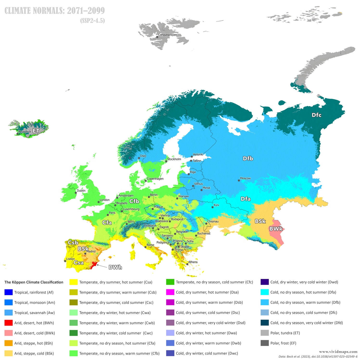
By 2099, the movement speeds up. The Mediterranean climate extends deep into southern France and spreads into more of the Balkans and Spain’s interior. Humid subtropical zones expand northward from Italy and the Balkans toward Poland. Continental climates shift further northeast, with cooler variants pushed into areas that are currently subarctic. Subarctic zones retreat dramatically in Scandinavia and Russia. Mountain tundra disappears from all but the highest Alpine peaks. The UK and Ireland see their oceanic climate become warmer. Some southern European areas cross from Mediterranean into semi-arid steppe.
Over this timespan, climate zones migrate hundreds of kilometers northward. In 1930, Mediterranean stayed on the Mediterranean. By 2099, it’s in southern France. What was oceanic becomes Mediterranean. What was continental becomes oceanic. What was subarctic becomes continental. Some areas that were Mediterranean become semi-arid as temperatures rise and precipitation patterns shift.
The coldest zones contract toward the Arctic coast or disappear. This changes agriculture, water supplies, forests, and what kinds of buildings you need. Wine regions migrate north. Forests adapted to cooler conditions struggle with heat. Rivers change when they flood. Buildings designed for one climate face another. Species that need specific conditions either lose habitat or expand their ranges.
I made maps for 1931–1960 and 2041–2070 too. The full sequence:
Data and Methods: Maps use the 1 km Köppen-Geiger dataset from Beck, H.E., et al. (2023), “High-resolution (1 km) Köppen-Geiger maps for 1901–2099 based on constrained CMIP6 projections,” Scientific Data 10, 724 (https://www.nature.com/articles/s41597-023-02549-6).


?")


