The Rise and Fall of Civilizations: An Animated Map of North American History
“North America’s history is a vivid chronicle marked by the rise and fall of civilizations, dynamic shifts in power, and dramatic changes brought about by European colonization. This animated map of North America takes you on a captivating journey from 1500 BC to the present, illustrating how this diverse continent evolved over millennia. Join us as we explore the fascinating timeline of North America’s history, highlighting key events and transitions that shaped the land we know today.
As you watch the animated map, notice how the landscape of North America changes dramatically, from the early civilizations that flourished long before European contact, to the significant impacts of colonization, and finally, to the establishment and growth of modern nations.
Timeline of Territorial Changes in North American History
1500 BC – 1500 AD: Early Civilizations and Pre-Columbian Era
- 1500 BC: The Olmec civilization emerges in present-day Mexico, establishing early territorial boundaries in Mesoamerica.
- 900 AD: The Ancestral Puebloans (Anasazi) built cliff dwellings and pueblos, marking their territory in the American Southwest.
- 1100 AD: The Aztec Empire establishes its dominion over central Mexico, with Tenochtitlán as its capital.
- 1300 AD: The Iroquois Confederacy formed in the northeastern woodlands, creating a powerful alliance and defining territorial boundaries.
1500 – 1700 AD: European Exploration and Colonization
- 1492: Christopher Columbus arrives in the Caribbean, initiating European claims in the New World.
- 1519: Hernán Cortés conquers the Aztec Empire, leading to Spanish control over central Mexico.
- 1534: Jacques Cartier explores the St. Lawrence River, claiming territory in Canada for France.
- 1607: The English establish Jamestown, marking the beginning of English territorial claims in North America.
- 1620: The Pilgrims land at Plymouth Rock, further expanding English territory in present-day Massachusetts.
- 1682: Robert de La Salle claims the Mississippi River basin for France, naming it Louisiana.
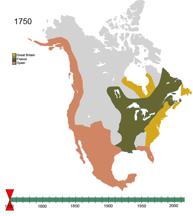
1700 – 1800 AD: Colonial Expansion and Conflicts
- 1754-1763: The French and Indian War reshapes territorial control, with Britain gaining French territories in Canada and the eastern Mississippi basin.
- 1763: The Treaty of Paris ends the war, ceding Canada and Florida to Britain while Spain gains Louisiana.
- 1776: The Declaration of Independence is signed, initiating the American Revolutionary War.
- 1783: The Treaty of Paris recognizes American independence, with the United States gaining territory east of the Mississippi River.
- 1803: The Louisiana Purchase doubled the size of the United States as France sold vast territories west of the Mississippi River.
1800 – 1900 AD: Expansion and Manifest Destiny
- 1819: The Adams-Onís Treaty cedes Florida to the United States and defines the boundary between U.S. and Spanish territories.
- 1836: Texas declares independence from Mexico, eventually becoming the Republic of Texas.
- 1845: Texas is annexed by the United States, leading to the Mexican-American War.
- 1848: The Treaty of Guadalupe Hidalgo ends the war, with Mexico ceding California and much of the Southwest to the United States.
- 1867: The United States purchases Alaska from Russia, further expanding its territory.
- 1898: The Spanish-American War resulted in the U.S. acquiring Puerto Rico, Guam, and the Philippines, although not part of North America, it reflects the U.S. territorial expansionist policies.
1900 – Present: Modern Era and Contemporary Boundaries
- 1917: The United States entered World War I, marking its emergence as a global power and influencing territorial arrangements worldwide.
- 1941-1945: The U.S. plays a crucial role in World War II, leading to post-war economic prosperity and geopolitical influence.
- 1949: Newfoundland joins Canada as its tenth province, reflecting modern adjustments to territorial boundaries.
- 1994: The North American Free Trade Agreement (NAFTA) comes into effect, strengthening economic ties and influencing regional cooperation between the U.S., Canada, and Mexico.
- 2020: The COVID-19 pandemic affects millions across North America, bringing unprecedented challenges and changes.
Explore More Maps of North America
For those fascinated by the dynamic history and geography of North America, here are some highly recommended maps available on Amazon:
- National Geographic: North America Classic Wall Map – This detailed map features political boundaries, major cities, and geographical features, perfect for history enthusiasts and students alike.
- North America Wall Map (Atlas of Canada) – A comprehensive map detailing political and geographical features, ideal for educational and decorative purposes.
- North America Wall Map GeoPolitical Edition by Swiftmaps – A beautifully illustrated map showcasing North America’s physical and political features.
- North America Physical Map by Maps of the World – This physical map focuses on the continent’s natural features, such as mountains, rivers, and plains, providing a unique perspective on North America’s geography.
- Large Political North America Wall Map by Maps International – A detailed political map that highlights key regions, landmarks, and geographical features across North America.


