Yoshida’s 1929 Bird’s Eye View of Korea
Yoshida Hatsusaburō (吉田初三郎) made over 3,000 maps in his lifetime. What made him genuinely unusual was the process: before picking up a brush, he would spend months walking the territory, talking to locals, hunting down the details a survey instrument can’t give you. His maps weren’t topographically precise – by his own admission they were deformed, stretched, and sometimes illogical in their proportions. But they felt real in a way that accurate maps rarely do, which is probably why Japan’s Ministry of Railways eventually adopted his style for all its major public transportation networks.
This is the map he produced in 1929 for the Korean Peninsula.
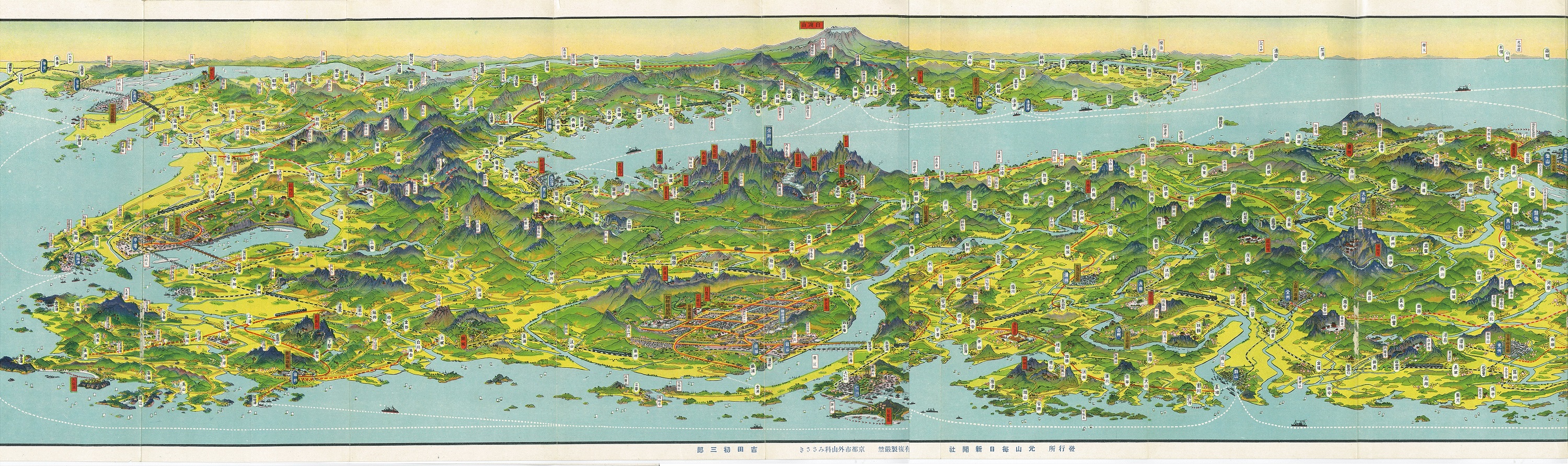
The title is 朝鮮大圖繪, which translates roughly as “Large Drawn Map of Korea.” It was published by the Gensan Mainichi Shimbun, a newspaper based in Wonsan on Korea’s eastern coast, and printed by Kankōsha – the Kyoto publisher that had become Yoshida’s primary collaborator throughout the 1920s. The cover carries the seal of the Government-General of Chōsen, and before it could be distributed, the view needed approval from naval garrisons at both Jinhae and Yeongheung – a reminder that in 1929, even a folding tourist map was subject to military censorship.
The format feels unusually elongated. At 23.5 by 128 cm (9.25 by 50.5 inches), nearly five times wider than it is tall, it pushes the peninsula into a long horizontal panorama oriented roughly northeast. At the far left, Qingdao appears on the Chinese coast. At the far right, Osaka and Tokyo. The Korean Peninsula fills the center, with Keijō (Seoul) dominating near the middle.
Cities and towns are marked in white and blue bubbles. Cultural sites – temples, shrines, hot springs, the sacred peaks of Mt. Kumgang (金剛山) and Mt. Paektu (白頭山) – appear in red boxes. Shipping routes connect the peninsula to Japan, Manchuria, and eastern China. Industries and resources are called out in yellow circles across the different regions. And threading through everything are the railways, with an inset railway map of the whole peninsula tucked into the inside cover, alongside a photograph of the Yalu River bridge connecting Andong and Sinuiju, completed in 1911 – the physical link between the Korean Peninsula and the Asian mainland.
| Category | Colonial Korea / Chōsen (1929) | Korean Peninsula (2025) |
|---|---|---|
| Total peninsula population | ~21 million (early 1930s census) | ~78 million (South ~52M + North ~26M) |
| Keijō / Seoul population | ~677,000 (1930 census) | ~9.6 million (2024) |
| Busan (Pusan) population | ~248,000 (1930 census) | ~3.3 million |
| Urban population share | ~3% of total | South Korea: ~81% North Korea: ~64% |
Japan had established effective control over Korea’s domestic affairs by 1905, and in 1910, Korea was annexed outright. By 1929, the total population of Chōsen (Korea) had grown to over 21 million, of which Japanese residents numbered approximately 561,000 – less than 3%. The urban population of Korea was still no more than 3% of the total during this period. Keijō (Seoul) itself had around 677,000 residents by 1930, growing fast but still dwarfed by Tokyo or Osaka.
The Yoshida’s map of Chōsen (Korea was produced for a specific occasion. The Chōsen Exhibition (朝鮮博覧会) was held to mark the 20th anniversary of Japanese colonial rule in Korea, at Gyeongbokgung palace in Keijō (Seoul), from September 12 to October 31, 1929, drawing 986,179 visitors. The exhibition’s stated purpose was to demonstrate to Japanese audiences on the home islands what two decades of colonial rule had achieved – and the map fits that framing precisely. Its back side is a full railway guide for the peninsula, with descriptions of major lines and expansion plans, and suggested tourist itineraries including Mt. Kumgang. The intended reader was a Japanese tourist traveling to Korea for the exhibition.
A nationwide student uprising originated in Gwangju in November 1929, just weeks after the exhibition closed, demanding an end to Japanese discrimination – a sharp counterpoint to the official celebratory tone of everything the exhibition had projected.


