Concentrations of plastic debris in surface waters of the global ocean
Plastic debris has now become the most serious problem affecting the marine environment, not only for coastal areas of developing
Read MoreMaps depicting environmental degradation across planet.
Plastic debris has now become the most serious problem affecting the marine environment, not only for coastal areas of developing
Read MoreInformation from the GOCE gravity satellite that ran out of fuel and fell to the earth two years ago, is
Read More26% of the world’s mammals are threatened. The map above shows the 4 countries with over 90 threatened mammal species
Read MoreСarbon dioxide levels differ in the northern and southern hemispheres and distinct swings in global CO2 concentrations as the growth
Read MoreFine-scale patterns of terrestrial diversity. (A) The numbers of threatened mammal species and (B) those with ranges smaller than the
Read MoreThe average rainfall for the continent is about 670 mm per year but the spatial and temporal distribution is very
Read MoreThe Rainforest Alliance’s work is driven by the principle that the health of the land is inextricably linked to the
Read More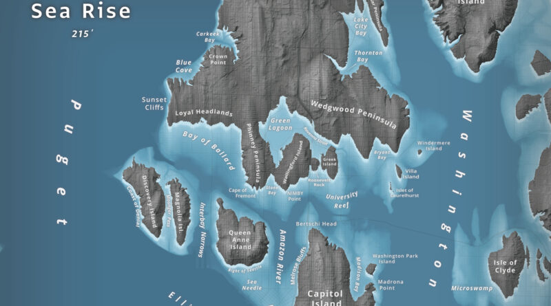
What happens to Seattle when 66 meters of water flood Puget Sound? Jeffrey Linn used LiDAR elevation data to map the city as an archipelago, where Capitol Hill becomes “Capitol Island” and the Space Needle turns into the “Sea Needle.” He created two versions with different cartographic styles.
Read More– Nearly one in every five deaths of children under the age of five worldwide is due to a water-related
Read More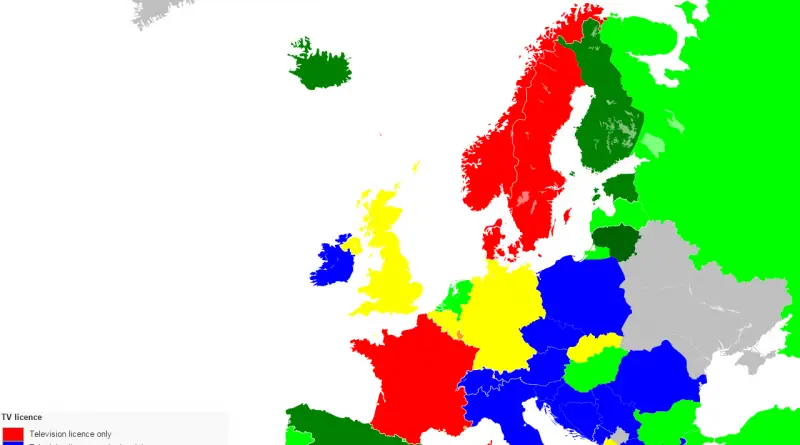
Norway had the highest per capita funding of public television in 2015: €136. Denmark was at €91, while Finland, which
Read More