France’s borders haven’t always looked the way they do today. Over the centuries, they’ve shifted, stretched, and shrunk—reshaped by wars, royal marriages, diplomacy, and politics. What we now think of as France is the result of centuries of change, some slow and diplomatic, others abrupt and bloody.
The story begins in the medieval era, especially under the Capetian dynasty. These early French kings didn’t start out ruling all of what we now call France. Far from it. But through a mix of military campaigns, strategic marriages, and careful diplomacy, they gradually pulled together a patchwork of territories. Regions like Normandy, Aquitaine, and Provence were added over time, turning the medieval kingdom into something closer to a unified state.
A major turning point came during the Hundred Years’ War (1337–1453). This long and brutal conflict with England wasn’t just about thrones—it was also about land. As the war dragged on, the French gradually reclaimed territory, pushing English forces out and consolidating their grip on the heart of France.
In the 16th century, during the Renaissance, France expanded its reach again, especially under Francis I, who aimed to make his mark in Italy. But it wasn’t all forward momentum. The French Wars of Religion tore the country apart for decades. At the time, areas like Brittany and Burgundy held on to significant independence, showing that France was still a country with strong regional divides.
Then came Louis XIV, the so-called Sun King, who ruled for more than 70 years and pushed France’s borders even further. Through a mix of military force and treaty-making, he added regions like Alsace, Lorraine, and parts of the Low Countries to the kingdom. His reign was one of the high points of French expansion.
That high point didn’t last forever. The French Revolution and the rise of Napoleon Bonaparte at the end of the 18th century completely transformed France’s place in Europe. Under Napoleon, French influence spread from Spain to the edge of Russia. But after years of war, it all came crashing down. France lost territory, and the old royal family was brought back.
The 19th and 20th centuries were full of border changes too. After the Franco-Prussian War in 1871, France lost Alsace-Lorraine to the newly formed German Empire—a huge blow. The region returned to France after World War I, only to be taken again during World War II, and then finally returned once more in 1945.
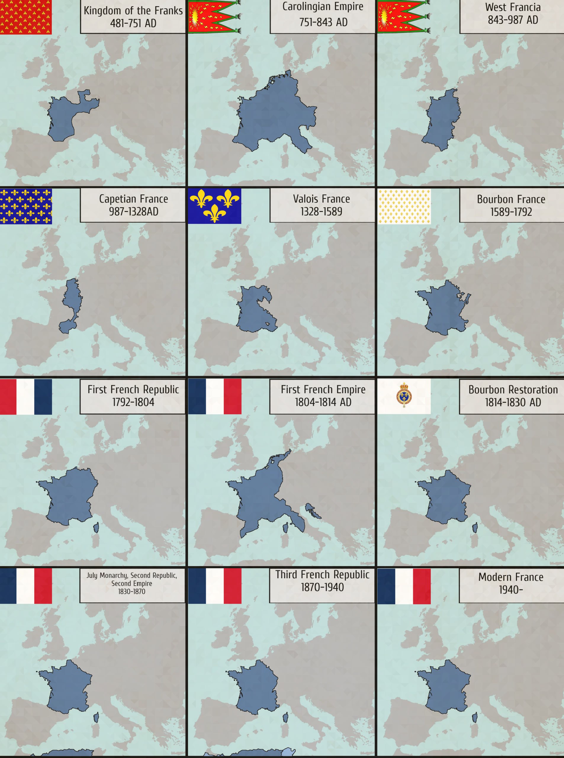
The atlas of maps below shows the evolution of France’s borders.
Today, France’s borders are stable—but that doesn’t mean the story has stopped. The country has taken a leading role in European integration, helping shape what became the European Union. Through treaties and agreements, France now shares sovereignty with its neighbors in ways that would’ve been unthinkable in earlier centuries. Instead of fighting over borders, European countries now cooperate across them.
Interested in delving deeper into the history of France? Explore these captivating books for a comprehensive understanding.