Farming did not start in just one place. It arose independently in China, developed again in the Andes, and emerged here too, in a curved strip of land across the Middle East. This one may have come first, somewhere around 9500 BCE.
People call this strip the Fertile Crescent. An archaeologist named James Henry Breasted coined the term in 1916 in a history textbook. He noticed the fertile land curved into a rough crescent shape, running from the Persian Gulf up through Mesopotamia and over to the Mediterranean coast. It was bordered by desert on one side and mountains on the other.
Wild wheat and barley grew here naturally. They also had a strange advantage. They could pollinate themselves. A single patch didn’t need a second population growing nearby just to set seed. For a hunter gatherer trying to encourage a plant on purpose, that’s a serious head start.
Climate helped too. When a stretch of cold, dry weather hit the region around 10,900 BCE, wild grains that had been easy to find suddenly weren’t. Scientists call this cold spell the Younger Dryas. Some researchers connect that scarcity to the shift toward deliberate planting. Others aren’t so sure the link is that direct.
Here’s the part that connects to something much bigger. A farmer who grows more grain than his family eats frees someone else up. Maybe a neighbor. Eventually, a whole class of people who don’t farm at all. The archaeologist V. Gordon Childe built a theory of early states around exactly this idea, back in 1950. Priests needed to eat. So did soldiers. So did officials. None of them grew their own food. None of this happened right when Jericho or Göbekli Tepe were founded. It took thousands more years.
Animals played their own part, just later than most people assume. Sheep, goats, and cattle were kept for meat only, at first. That’s it. Just meat. Then, around 4000 BCE, something shifted. People figured out they could milk these animals, shear their wool, and hitch them to a plow, all without killing them first. By the time cities like Uruk rose in southern Mesopotamia, people needed a way to track whose grain belonged to whom. That accounting problem is what pushed them to invent writing. The earliest clay tablets from Uruk aren’t poems. They’re receipts.
Domesticated Species of the Fertile Crescent
Crop or Animal
First Domesticated
Approx. Date (BCE)
Einkorn wheat
Southeastern Turkey
8,600 to 8,000
Emmer wheat
Southeastern Turkey
8,600 to 8,000
Barley
Levant and Zagros foothills
9,500 to 8,000
Lentil
Southern Levant
9,500 to 8,500
Pea, chickpea, bitter vetch
Fertile Crescent
8,800 to 7,000
Flax
Fertile Crescent
8,800 to 7,000
Sheep
Zagros Mountains
11,000 to 9,000
Goat
Central Zagros, Iran
8,200
Cattle
Southeastern Turkey to the Zagros
8,500
Pig
Eastern Turkey
8,000 to 7,000
That early advantage didn’t last. Rivers that irrigate a field for centuries also leave salt behind in the soil. That’s just what irrigation does over time. Sumerian farmers were already struggling with salty fields by 2000 BCE. Some of that same ground in Iraq and Syria is still being farmed today. Add a century of borders drawn by outside powers after the Ottoman Empire fell, then decades of war, then ongoing disputes over the Tigris, Euphrates, and Jordan rivers. Tragically, the regions that invented agriculture now rank nowhere near the top of the world’s income tables.
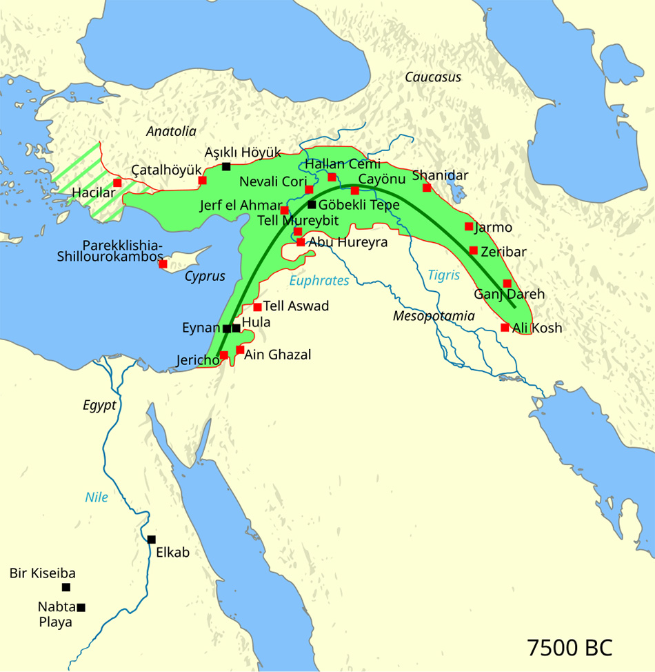
A map of the region from around 7500 BCE shows where all of this got started.
Among the eighteen settlements shown on the map above, only one has evolved into a place where people still live today. That one is Jericho, in the West Bank. People have lived in this oasis, on and off, since about 9000 BCE. In 2023, UNESCO officially inscribed its ruins as a World Heritage Site, recognizing it as the oldest fortified town on Earth. The modern city itself is unusually low. It lies 258 meters, or 846 feet, below sea level, lower than any other city on the planet. Around 20,000 people still call it home today
Everyone else eventually left. Take ʿAin Ghazal, across the Jordan River in modern Jordan. At its peak, it held roughly 3,000 people, far more than Jericho at the same time. Then, around 5000 BCE, people abandoned it entirely. The modern capital of Amman has since grown out to swallow the ancient site.
Abu Hureyra had an even stranger fate. It was excavated in a panicked hurry between 1972 and 1973. Shortly after, Syria’s Tabqa Dam filled Lake Assad, sending the entire ancient site underwater. Four more nearby settlements met the same fate over the next few decades, all drowned a second time by dams built for power and irrigation. The Atatürk Dam in Turkey alone flooded 191 separate archaeological sites when its reservoir filled.
Two of the eighteen sites were never villages in the first place. Take Shanidar, a cave in Iraqi Kurdistan. Neanderthals sheltered there more than 60,000 years ago. That’s long before anyone in the region planted anything. Then there’s Lake Zeribar in Iran. Its deep mud holds layers of ancient pollen that scientists have studied for decades. They show how the local climate swung from Ice Age steppe to woodland.
The wetlands surrounding Eynan have a strange history of their own. People completely drained the marshland for farming in the 1950s. Decades later, in the 1990s, part of the valley was deliberately reflooded to repair the damaged ecosystem. Today, Agmon Hula has transformed into one of the planet’s most critical stopovers for millions of migratory birds.