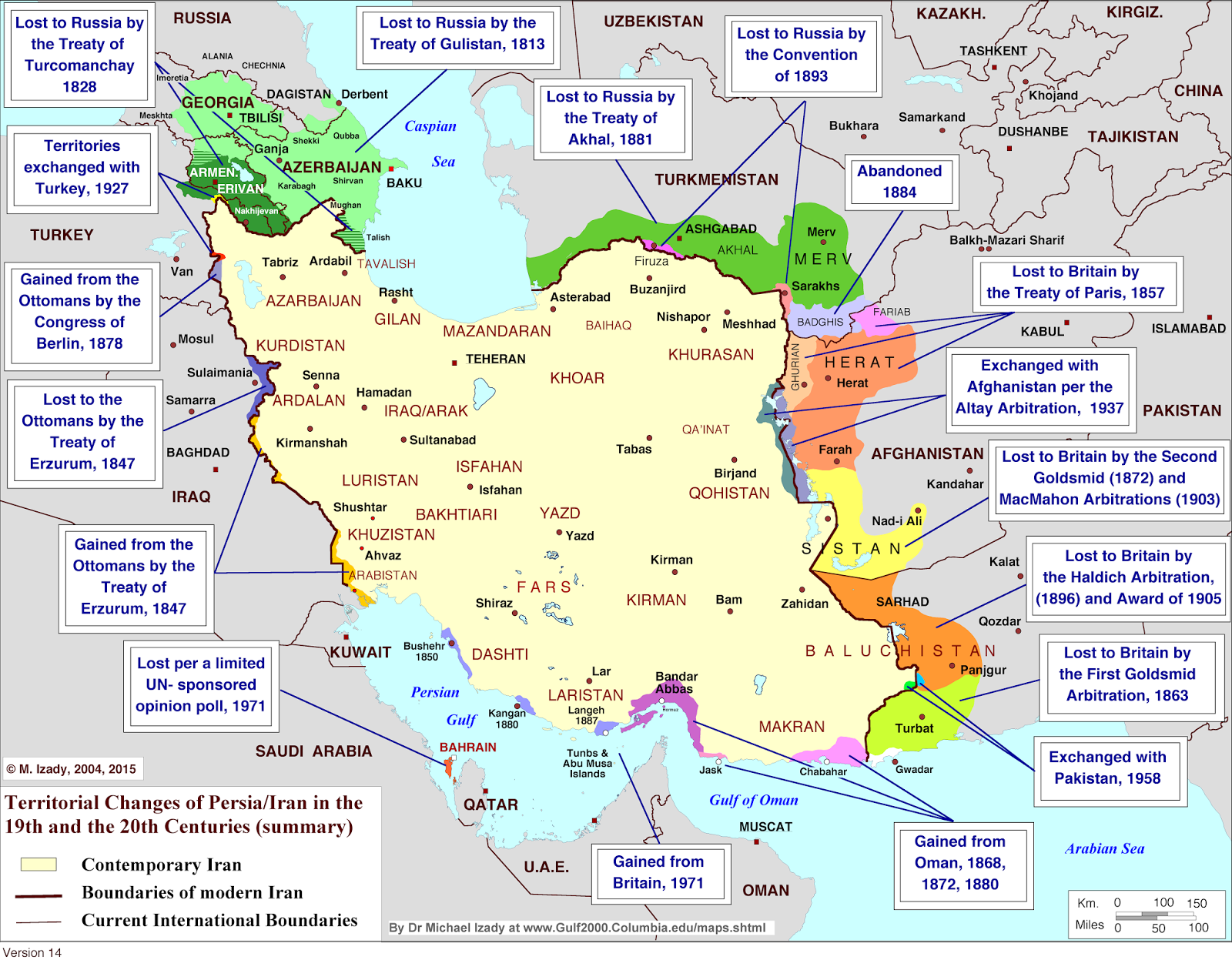
It’s easy to look at modern political maps and assume national borders have always looked this way. But borders are anything but permanent, and the case of Iran proves it. Over the past 200 years, the shape of Iran has changed dramatically. Wars, treaties, colonial powers, and diplomatic deals all chipped away at what was once a much larger Persian state.
A historical map created by Dr. Michael Izady of Columbia University’s Gulf2000 Project lays it all out clearly. It highlights every major territorial change Iran experienced between the early 1800s and the late 20th century. The source data for the map comes from historical treaties, arbitration records, and international agreements. You can view the map below in this post.
Russia from the North, Britain from the South
Iran’s biggest territorial losses came at the hands of two expanding empires: Russia and Britain.
Starting in the early 19th century, Russia pushed into the Caucasus. Iran lost vast regions—today’s Georgia, Armenia, and Azerbaijan—after two devastating wars. These losses were formalized in the Treaty of Gulistan (1813) and the Treaty of Turcomanchay (1828). Russia continued expanding into Central Asia, eventually claiming large parts of what’s now Turkmenistan and Uzbekistan through the Convention of 1881 and Convention of 1893. These weren’t minor border changes—they cut Iran off from its old sphere of influence in the north.
While Russia advanced from the north, Britain was making moves from the south and southeast. Iran lost Herat—now part of Afghanistan—after the Treaty of Paris in 1857. Then came a series of British-led arbitrations, most notably the Goldsmid Arbitration in 1872, that handed more land to what would later become Pakistan. These changes served British interests, helping protect the borders of British India.
Territorial Swaps with the Ottomans and Pakistan
Not all border changes were due to war. Some were the result of agreements between neighboring powers. In 1847, the Treaty of Erzurum caused Iran to lose some land to the Ottoman Empire but also gain some territory in return. Later, in 1927, there was another adjustment with modern-day Turkey that resolved lingering disputes.
There was also an exchange with Pakistan in 1958. Iran and Pakistan swapped small areas along their southeastern border to simplify administration and settle local disputes.
The 20th Century: UN Polls and Gulf Politics
The most recent changes on the map happened in the second half of the 20th century. In 1971, Iran officially took control of the islands of Abu Musa and the Tunbs in the Persian Gulf. These islands had been disputed, but Iran secured its claim after Britain pulled out of the region. Around the same time, Bahrain—long claimed by Iran—became fully independent after a UN-backed public opinion poll found the population did not want to be part of Iran.
Iran also reached agreements with Oman in the late 19th century and again in the 1970s, confirming its control over strategic waterways and solidifying its maritime borders.