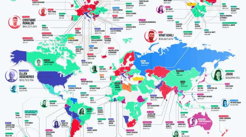
Political maps

Largest Subdivisions Mapped

A first-level subdivision or subnational entity is an officially outlined geographical division within a sovereign country. Such a division is designed to improve the responsiveness of a national government to sub-national activities. As such, a division is given some degree of administrative independence, which is considered as a form of limited self-government in some nations.

Read More
EarthEnvironment maps

Earth’s surface visualized

The Total Surface Area of our planet is about 509.6 million km² or 197 million mi². The land occupies only 29% of the Earth’s Surface (148.3 million km2 or 57.3 million mi²). The largest countries by surface area are Russia (3.35%), Canada (1.96%), China (1.88%), United States (1.87%), Brazil (1.67%), and Australia (1.51%). Together they occupy approximately 12.24% of the planet’s surface. 70% of the Earth’s total surface is covered with water (361. 7 million km² or 139. 7 million mi²).

Read More
Economic maps

Countries that don’t use their own currencies mapped

The majority of countries (131 nations and 4 dependent territories) use their own currency, 14 countries and ten dependent territories using their own money and currency of another country. And 12 nations don’t have their currency instead of using another country’s currency. In addition, there are 5 monetary unions (Euro, CFP frank East Caribbean Dollar, West African and Central African CFA franks).

Read More